Your shopping cart is empty!
Blog
- Details
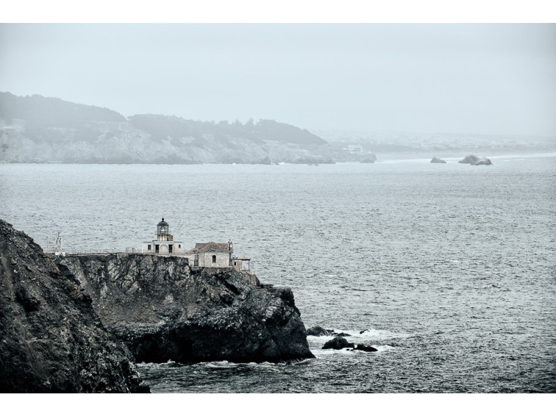
The Point Bonita Lighthouse
In July 2016, I wanted to visit the Point Bonita Lighthouse just before I took part in an art show in Silicon Valley. I already visited many places around the Bay Area but this lighthouse was still on my list. However, the hours the lighthouse is open are limited: back in 2016 I believe it was only open 3 days a week and of course I wasn’t there on the right day.
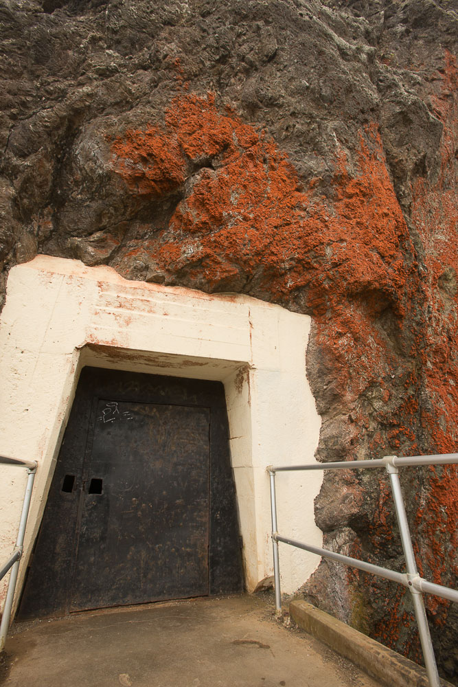
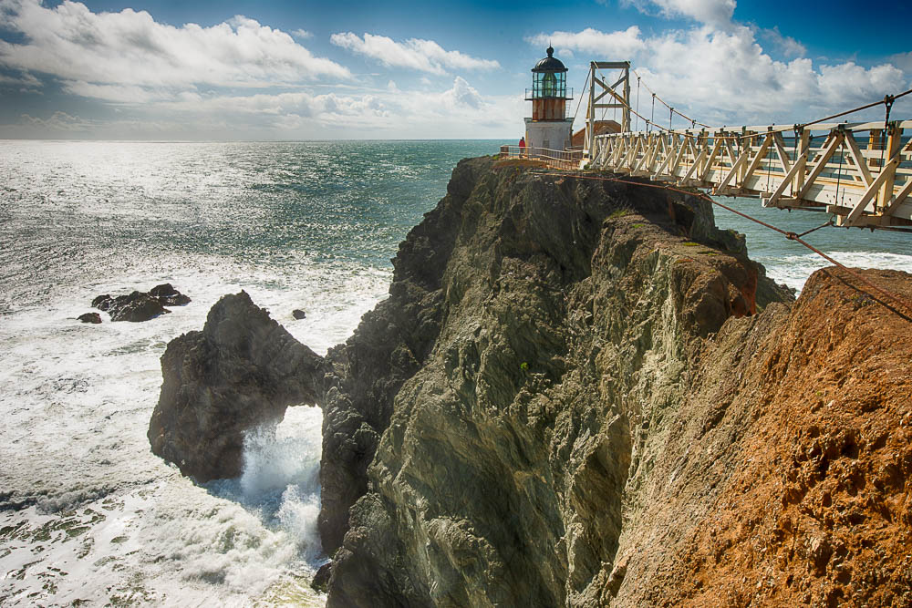
The location of it is intriguing: it sits on a large rock on the north shore of the Golden Gate Strait, barely connected to the mainland. In order to get there, you have to go through a tunnel, carved out of rock, and on the other side is a suspension bridge that leads to the lighthouse. On days the lighthouse is closed, the tunnel has a locked door, which I ran into.
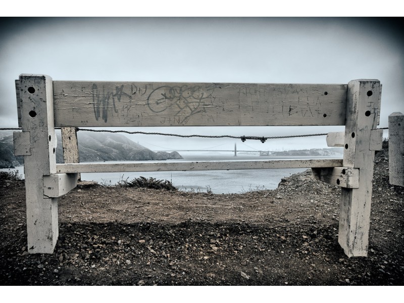
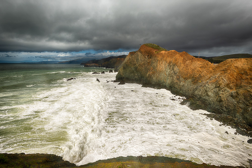
Instead of visiting the lighthouse, I walked around the area and got a shot of it from Battery Mendell about half a mile north of the lighthouse.
In March 2023, I went back when the lighthouse was open. I grabbed an Uber from downtown San Francisco and asked the Uber driver if I would be able to get an Uber easily from near the lighthouse and he said “Yeah.” The thing is, the lighthouse is kinda remote and I wasn’t sure about the phone reception there either. It was noon and my plane back to San Diego was leaving at 6:35pm at the Oakland Airport. Arriving at the lighthouse at 12:30pm would allow me plenty of time to take pictures, even walking to other spots in the area, and taking a ride back at around 3:30pm, right?
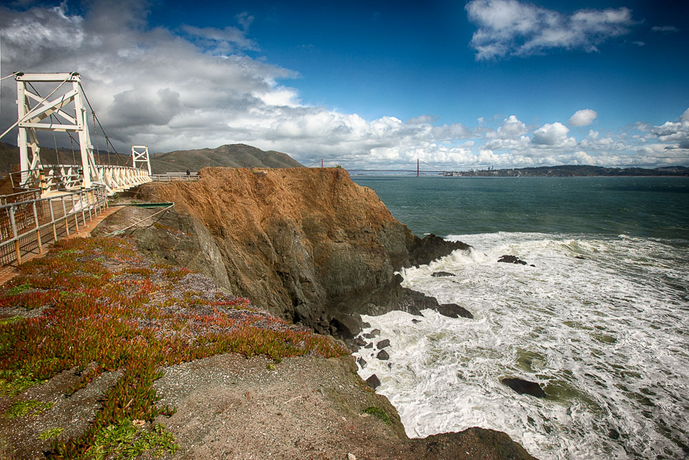
After the Uber driver dropped me off, I took the trail leading to the lighthouse. In 2016, I took a couple shots of the Golden Gate Bridge from here.
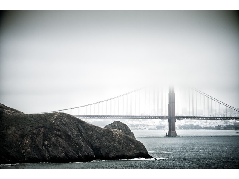
It was more foggy then. Today there was a mix of sunshine, rain, and wind. It had been pouring on and off during the weekend. Now it was sprinkling. In the northwest, dark clouds hung over the ocean and coastline.
This time the tunnel was open.
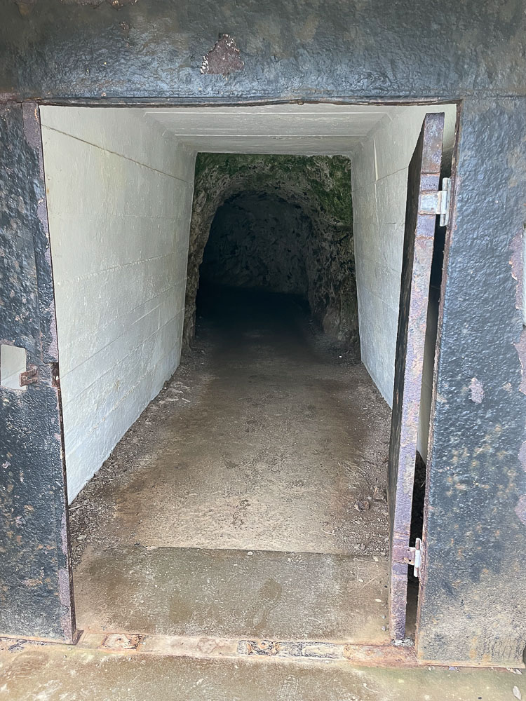
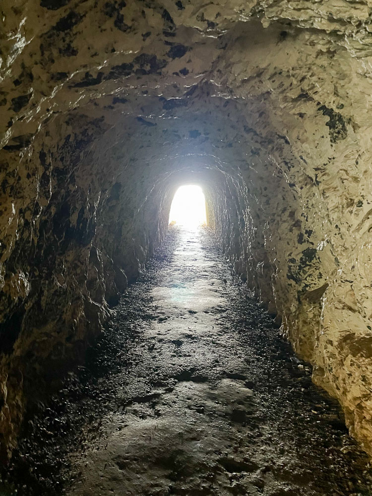
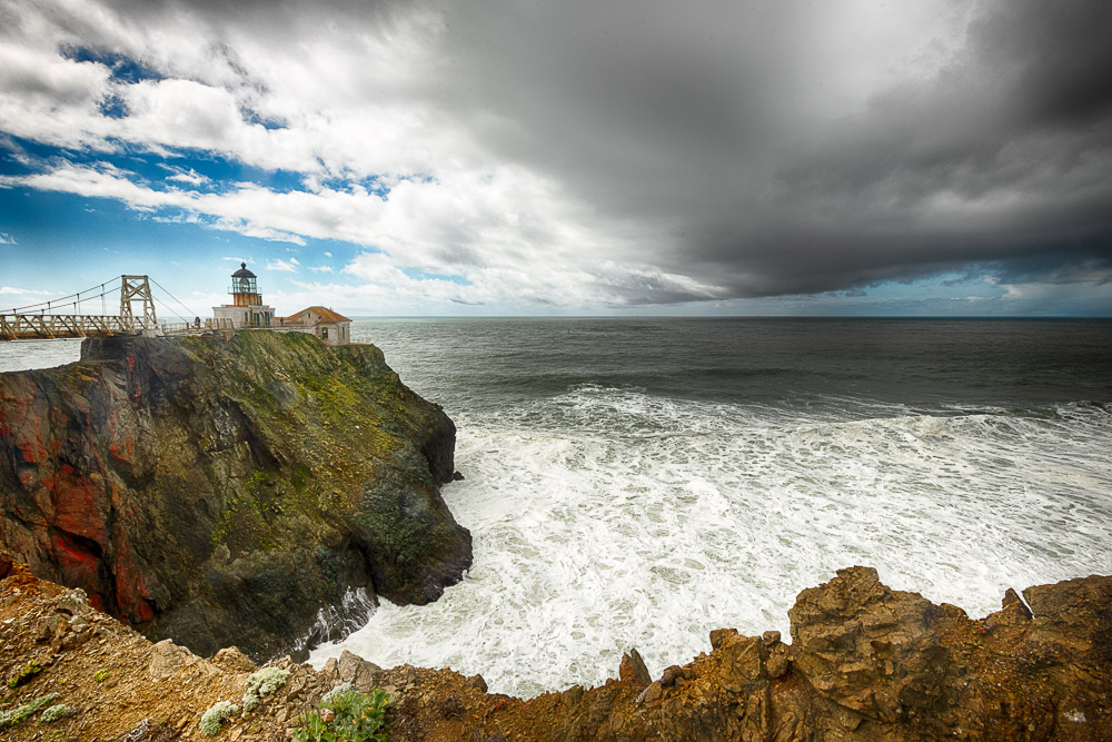
It wasn’t a very long tunnel. Once through the tunnel, the path continued between steep cliffs going down to the ocean and towering rocks. I was walking around a big rock, when I saw the suspension bridge and the lighthouse. I took a few images of them.
The park ranger was standing at the beginning of the suspension bridge and he told me to be careful: because it had rained, the bridge was slippery and there was a lot of strong wind. I could feel the bridge sway when I went over it.
A park volunteer was waiting on the other side. He told me that the ranger had made a good call to open the lighthouse. It was borderline open: at inclement weather (wind over 30 mph) it wouldn’t have been, but the dark clouds and big waves being swept up by the high winds added to the whole experience. I loved watching and listening to the waves pounding the cliffs at the north end of the islet.
The lighthouse was built in 1855, a year after the first lighthouse was built on the west coast at Alcatraz Island. Lighthouse caretakers lived in the little dwelling next to the lighthouse till 1986. After that it was automated. You can find more information on the National Park Service website.
The lighthouse itself sits on a type of strong basalt rock called diabase, which is a greenish color (also called greenstone) and is formed beneath basaltic volcanoes. Since these rocks are formed underwater they form pillow shapes and are also called pillow basalt. There are several natural arches in the area which are great examples of pillow basalt. You can see in the photo toward the east of the lighthouse there is also a brown-orange colored rock, which is also diabase, but more weathered and contains more iron oxide deposits.
I must have been one of the first people to arrive (I found out later that the lighthouse had opened at 12:30pm and not 9:30am as wrongly listed on Google Maps), because I was the only visitor at the time. More people started to show up and after taking lots of pictures I thanked the park ranger and took the trail back north after spending a little more than an hour.
I walked to the Battery Alexander parking lot and checked how long it would take to get to the Oakland Airport. About an hour. Luckily I had fairly good phone reception, so I had a look at the Uber app to see how long it would take for an Uber to get here. Only 8 minutes. I cooked up a plan to leave here at around 3:30pm so I would arrive 2 hours before my plane left. With an abundance of time available, I decided to visit some of the abandoned batteries (bunkers that used to contain canons) in the area. Many of which have nice views of the Pacific and of Fort Cronkhite down the hill.
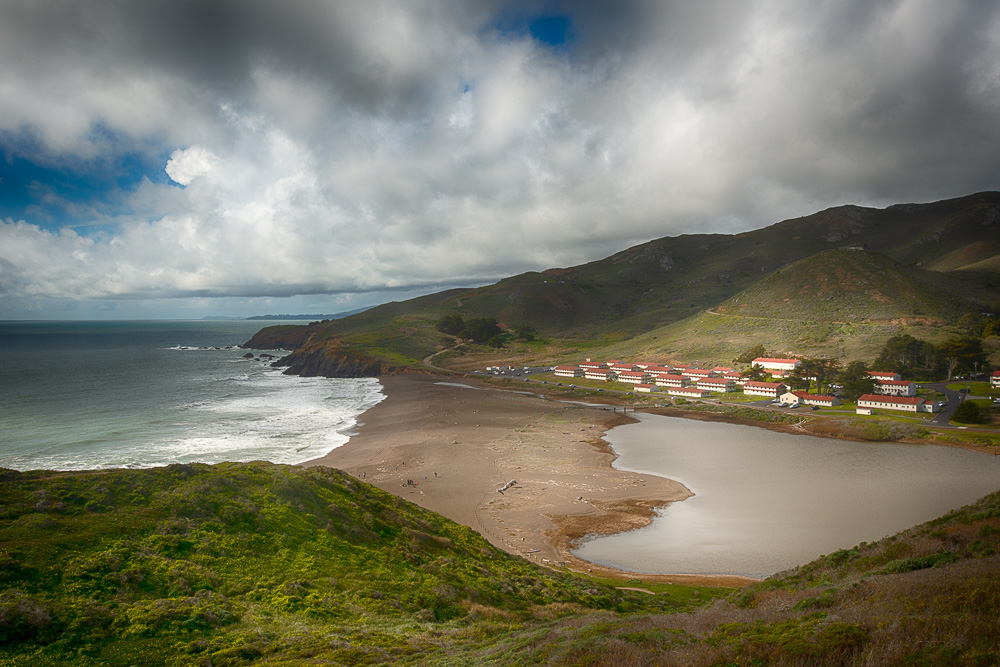
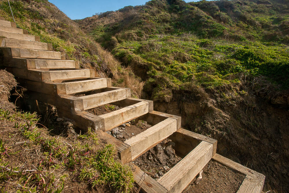
It was 2:45pm when I got back at the Battery Alexander parking lot. I looked to the west and noticed that I could take a trail down to South Rodeo Beach. When I got close to the beach there were some damaged wooden stairs, which were cordoned off with a path leading around it. I thought it looked funny because the stair steps were missing big parts.
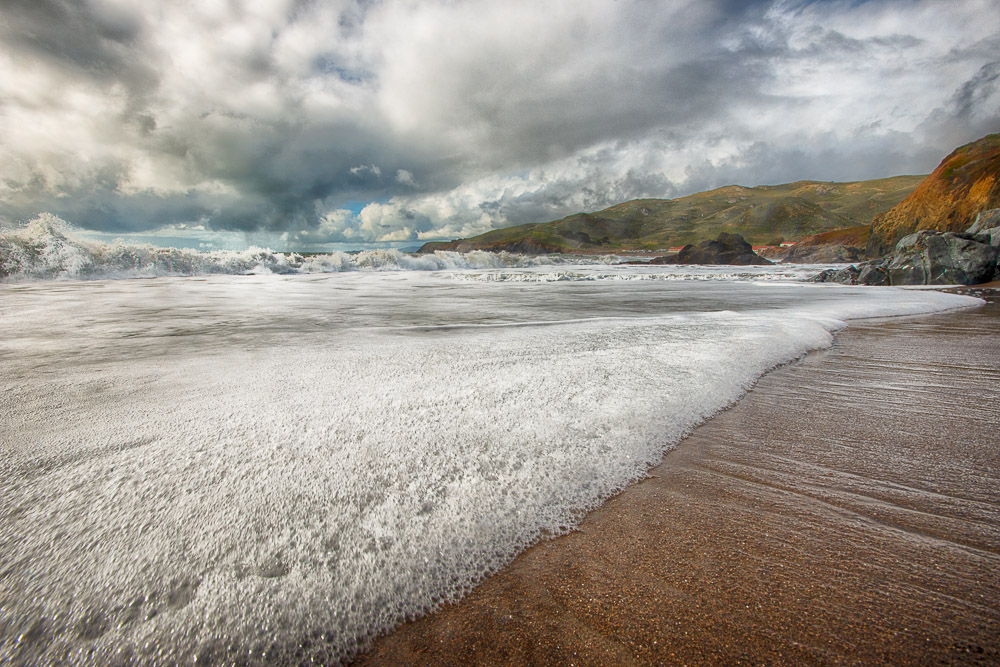
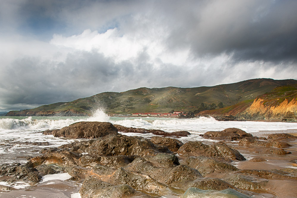
The beach had very dark sand and the waves were awesome, leaving a lot of foam in their wake. I tried to get some close-up shots of it with buildings at Fort Cronkhite in the far distance in the background.
Now it was 3:15pm. Surprisingly I had reception at this secluded beach. Uber still said it would take 8 minutes for a car to get here. So I ordered one to pick me up at the parking lot up the hill, which was a 8 minute walk. I patted myself on the back for my perfect time management: maximizing the number of photography opportunities and minimizing waiting times.
I was huffing and puffing when I arrived at the parking lot. I checked the Uber app to see how far my Uber was. “Finalizing driver details,” it said. Okay, so for the last 8 minutes it hasn’t confirmed a car yet. I waited a little longer when the message “UberX not available at the moment, try another Uber or try again later.” Hmm, I thought, perhaps this parking lot is too remote for drivers and I need to walk to a more populated area.
I started walking north on Field Road while trying again to summon an Uber. Then a red message appeared “Connection to our network lost”. I checked my bars. Zero. When I passed the Nike Missile Site I got back 1 bar and tried again, with a pick up location at the corner of Field Road and Bunker Road. “Confirming pick-up location” it kept saying and nothing else happened.
Reception went in and out and the Uber app never went past “Finalizing Driver Details.” It was 3:45pm when I got to the corner of Bunker and Field Roads where the reception was zero. I could go right, towards the Baker Barry Tunnel (2 miles, 43 minute walk) or to the left, towards Fort Cronkhite. The road to the tunnel leads through a narrow valley and I thought the reception was probably going to be non-existent the whole way. Left turn it is then.
Reception went from 0 to 1 to 0 while I was walking. When I got closer to Fort Cronkhite at Mitchell Road it started raining. Reception was zero and now it was 4pm. Was I going to miss my plane? Would I be able to get out of here at all? At a parking lot at the fort I got 1 bar back.
I was becoming worried but just in case I texted my wife that I may not be able to come back home today. I found some taxi number online and called it. “Sorry we don’t have anyone available right now,” the guy said. I called another number. The taxi guy said that they could have a cab pick me up in about 25 minutes. That would work, that would still get me at the airport at about half an hour before boarding.
I found some shelter against the rain behind a small information sign. My phone rang.
“This is such-and-such taxi company, you called for a taxi?”
“Yes.”
“Well, I am in heavy traffic and I cannot make it there till over an hour.”
“That doesn’t work for me, I would miss my plane.”
“Try such-and-such taxi company,” the guy said.
“Okay, I will, thank you.”
Before I called the other company at 4:15, I tried the Uber app again and chose a pick-up point exactly at where I was standing. I still had that one bar of reception and didn’t dare to move. “Finalizing Driver Details,” it said again. And again. And again… I called another taxi company but the guy on the other side of the phone didn’t know where Fort Cronkhite was. While I was explaining to him where I was, I checked the Uber app and was met with the most beautiful message known to man: “Driver Fred is on his way to the pick-up point” (or something like that). “Never mind,” I said, “somebody is picking me up.”
On the little Uber map, I could see that the car was on the other side of the tunnel at 2.5 miles away and it would take only 9 minutes or so for him to get to me.
After 5 minutes it still said 9 minutes, showing the car on the other side of the tunnel, so I hypothesized. I know reception sucks here so perhaps he is already on this side of the tunnel and the Uber app just doesn’t know that.
That hypothesis was confirmed as I saw a car pull up with the make and license plate number that was listed on the app.
What a relief! When I got in the car I checked traffic and it would take a little over an hour to get to the airport. Luckily, I would arrive still about 30 minutes before boarding.
But then the Uber driver started to get nervous. “I don’t have any reception here,” he said. I told him to just follow Bunker Road east and when you get on the other side of the tunnel you will get reception again. But he kept messing with his phone and mumbling that this drive may not be recorded with Uber. I tried to comfort him; that my app said that I had been picked up, so don’t worry. Now I was worried that he was going to throw me out at some point.
As expected, at the east end of Baker Barry Tunnel everybody got full-on reception again, his app confirmed he was driving me, my app said the same thing, and estimated travel time was now under an hour. We drove over the Golden Gate Bridge, through San Francisco, over the Bay Bridge, over Yerba Buena Island - where by the way I learned earlier at the Point Bonita Lighthouse that this is where the headquarters are of the Vessel Traffic Center that is responsible for the safety of vessel movements in the Bay Area. We drove through Oakland, and into the airport. I made it quickly through TSA and my gate was right on the other side.
I had acquired my photos, some exercise, gained new experiences, and a story to tell. The rest of the trip back to Carlsbad, California, was uneventful.