
Fight, Flight or Film
A story on how I created my digital painting “Fight, Flight or Film”
For almost four years I have been taking drawing and painting classes at the Watt's Atelier in Encinitas, California. Before then I had no idea that this highly regarded art school was pretty much in my backyard. People from all over the world go here to learn. Classes range from portrait and figure drawing and painting, landscapes, animals, and more conceptual ones as the Composition and Staging class I took in 2024. Media used in all the classes mostly include graphite, oil, and gouache. For this class I chose digital painting in Procreate on the iPad.
The class was taught by Erik Gist. He creates art for Marvel, DC Comics, Disney and others.
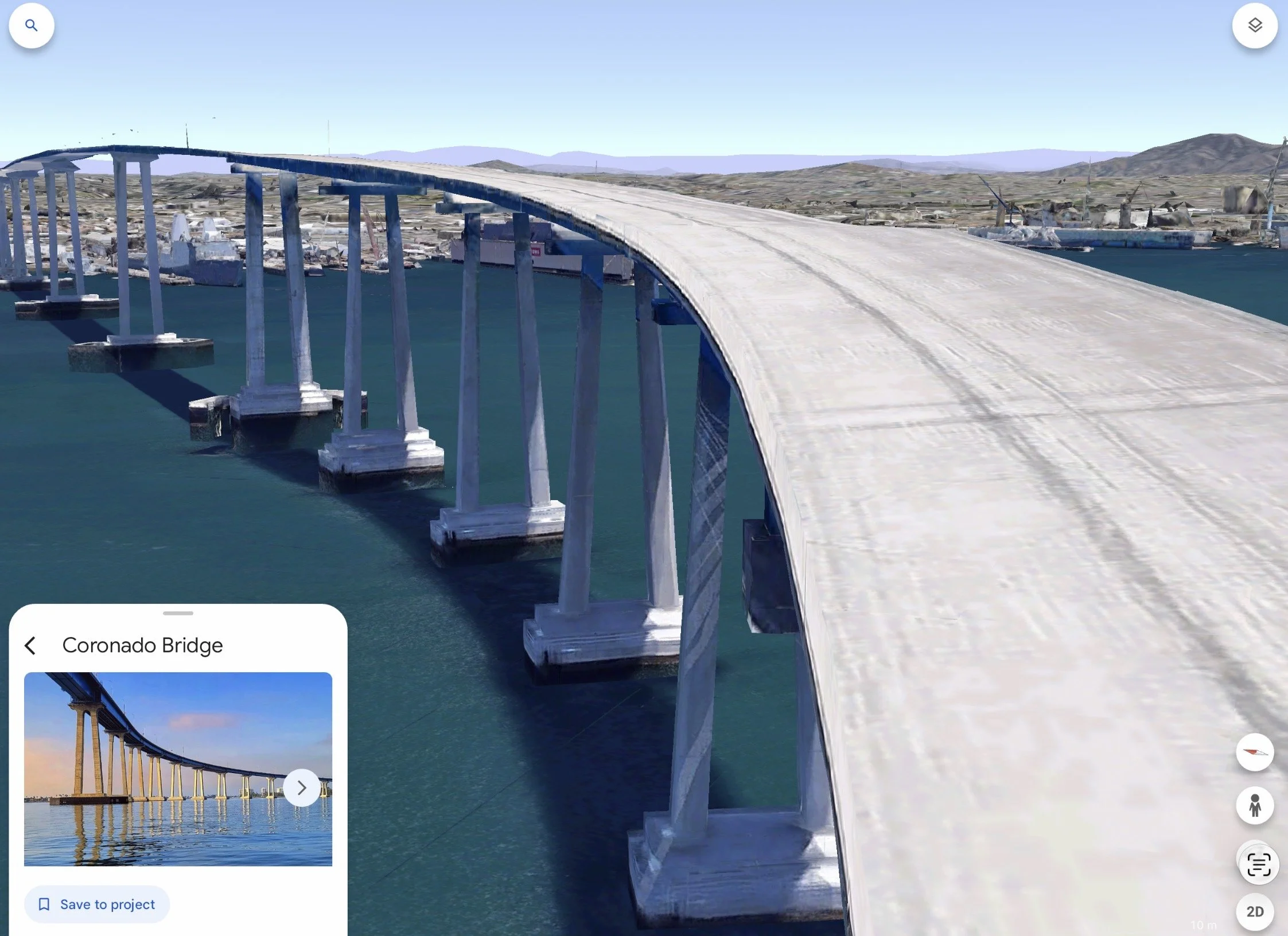
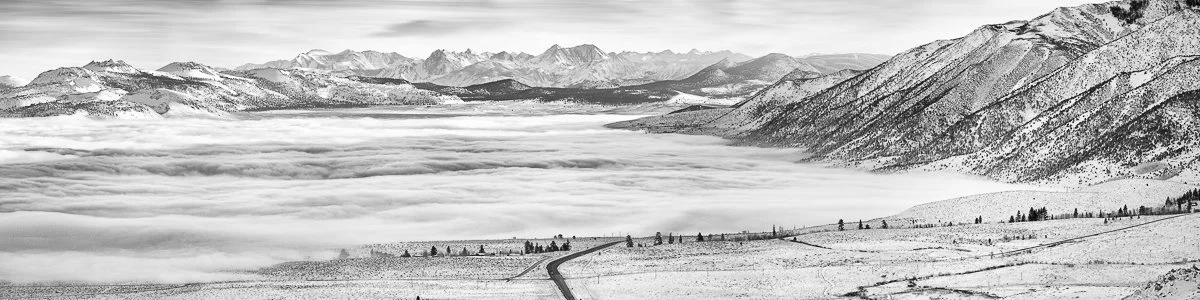
After some thinking I decided that I wanted something recognizable in the San Diego area and settled on a sea monster attacking the Coronado Bridge. It’s a famous landmark that connects San Diego to Coronado over the San Diego Bay. At its highest point it’s 200 feet above the water so that tall ships can still reach the farther parts of the bay. Because of its height, many people are uneasy driving over the Coronado Bridge. Some go so far as to detour through Imperial Beach to avoid it.
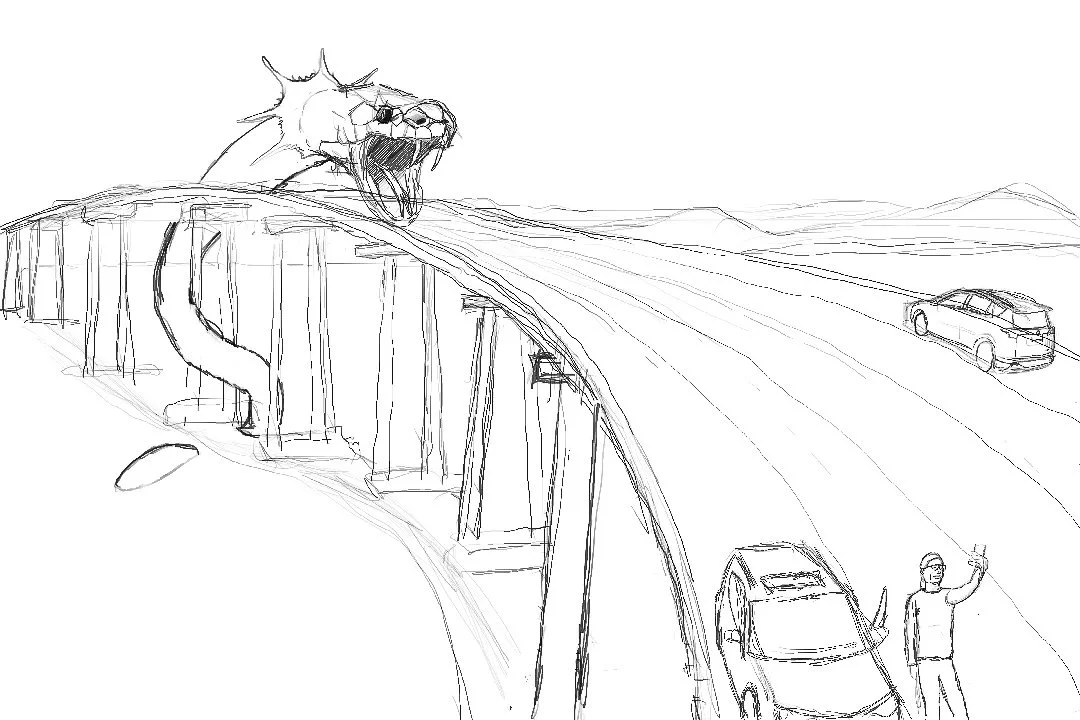
The next part of the class was to create a few quick sketches to get an idea for the final composition that would be rendered fully in detail towards the end of the class. I came up with these:
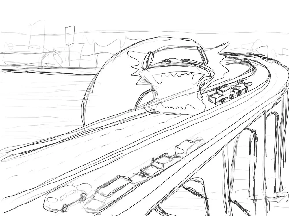
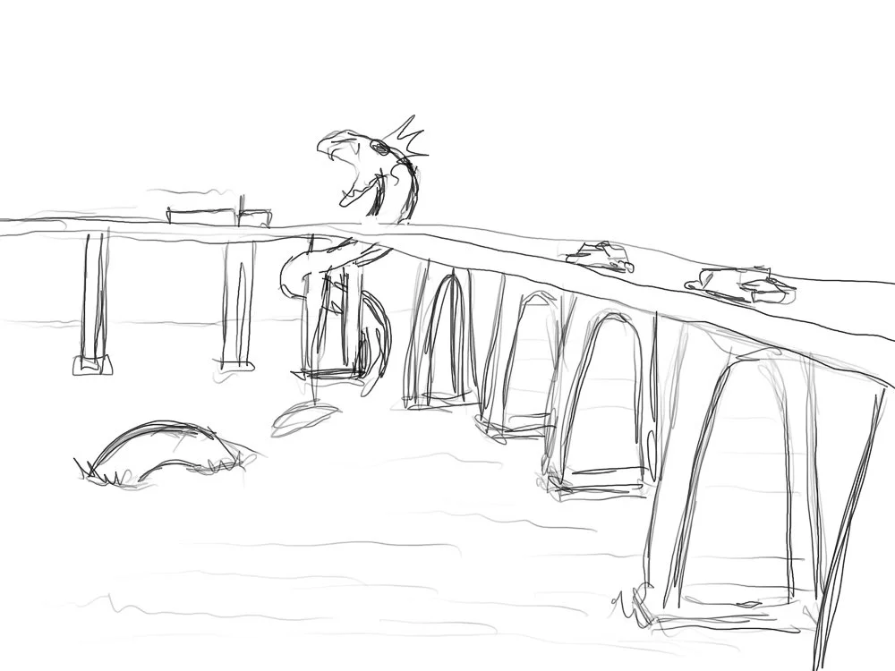
It is pretty much impossible to get a good reference photo of the bridge with my drone for any of these views, as there are many restrictions in the local airspace, so I decided to use Google Earth to get the view I wanted. I liked the view above the best, but I needed a little more space of the road so I could paint in the chaos that would unfold on the bridge:
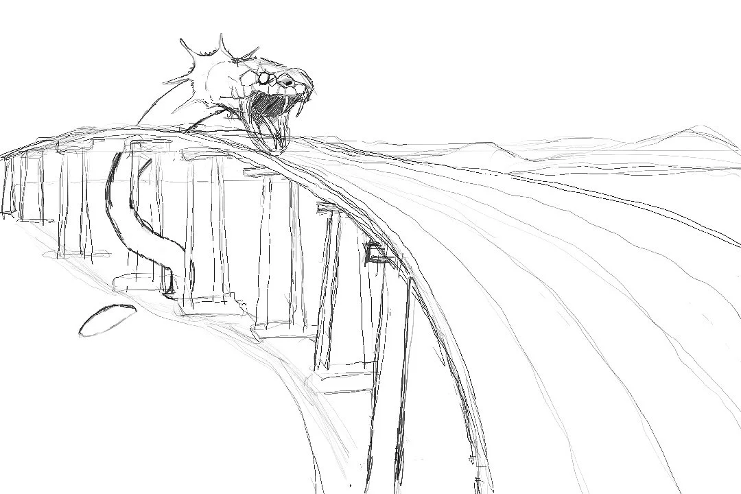
Happy with this view, I started sketching.
I drew the monster as a large snake, with a large frill behind its neck, kind of like the chlamydosaurus kingii.
Now it was time to come up with some scenes happening on the bridge. I figured that these days, at least one person would stop to take a selfie while chaos unfolds in the background.
However, I wasn’t too happy with this result. Fortunately, our teacher Erik mentioned that he regularly uses himself as a model for his paintings. So I asked my wife Marie to model for the crazy woman who would stop on the Coronado Bridge to take a selfie with the monster in the background. Marie had the brilliant idea that she would also hold our dog in her arms while doing that! In order to keep more or less the correct perspective I climbed a ladder and took some pictures of her. Then, I thought, I can take more reference photos of myself and our daughter Kate to create some additional scenes:
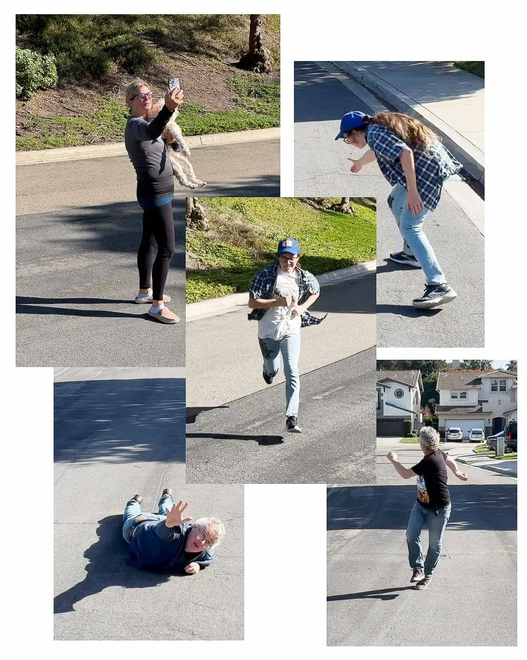
All of these made it into the painting, including a few more of Kate exiting and running away from the car. I also pretty much shot every car in our neighborhood, which also made it into the painting.
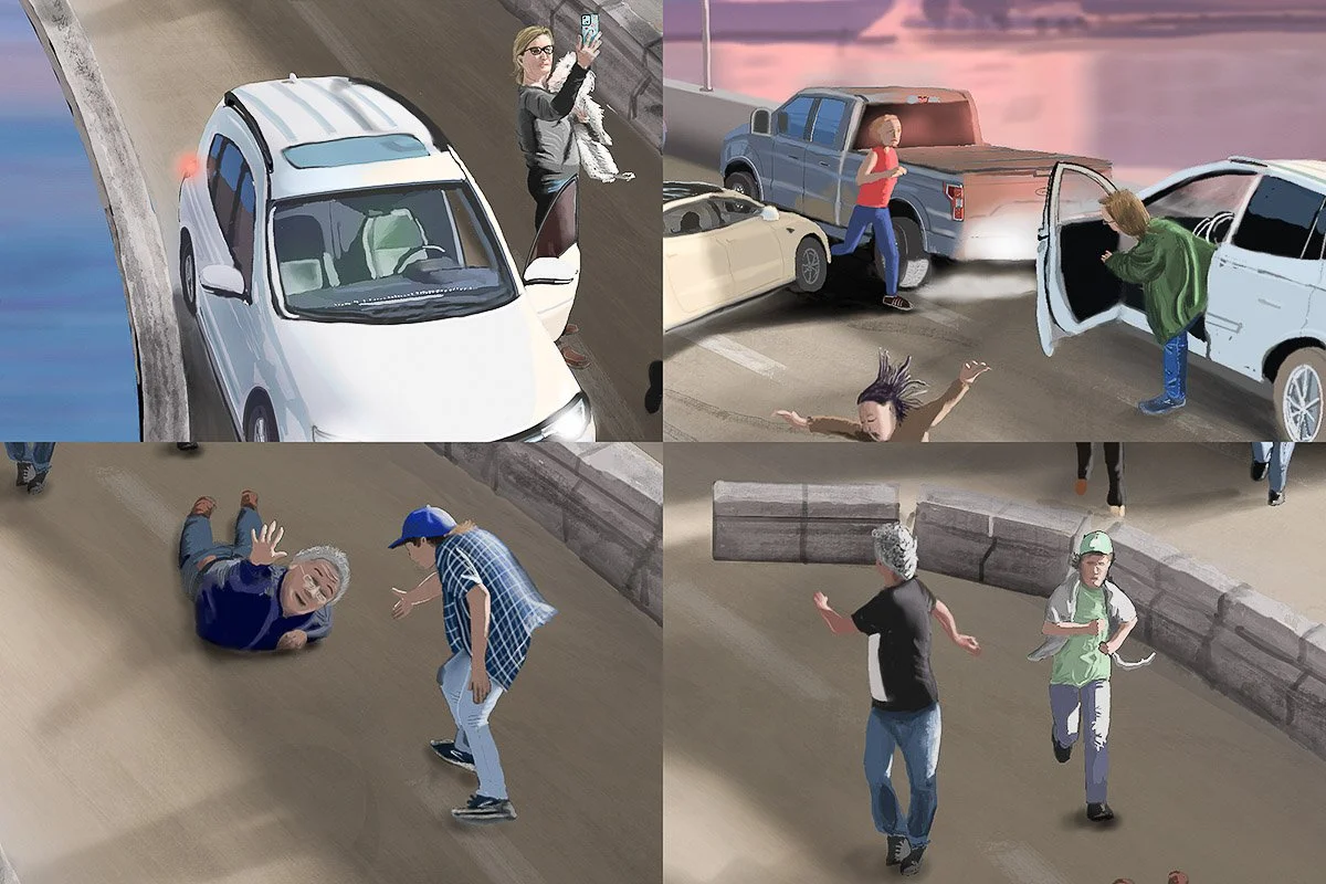
In the end I changed the monster a bit. I removed the frill and added lots of teeth. Somewhere sometime I saw a monster with many irregular teeth and gave that to mine. And finally, for some interesting lighting I chose a sunset. This not only adds some warm colors to the sky, but it also provides long shadows throughout the image. The light is warm on the sunny sides and cool on the shadow sides. Kate came up with the title.

From June 10th to July 5th, 2026 a framed 16×24” print of “Fight, Flight or Film” will be on display at the San Diego County Fair Fine Art Exhibition at 2260 Jimmy Durante Blvd, Del Mar, California.

From “All Mine!” to “All Mine! The Way It Should Be”
From “All Mine!” to “All Mine! The Way It Should Be”
All Mine!
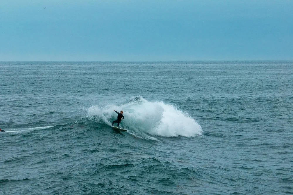
One of the places I first visited after buying my Nikon D800 in 2012 was Windansea Beach in La Jolla, California, in order to capture the shack.
But how you capture an iconic scene that has been photographed many times before is always a creative challenge. Sometimes I do some research before I go to a location by looking at it on Google Earth from different perspectives (for example for my shot of "Good Morning Coachella!" on YouTube). Then, when I get there, I take lots of photographs from different angles after walking around a bit. This time it was different.
I was able to park my car in the little parking lot along Neptune Place and I walked over to where Bonair St hits Neptune. I put my tripod on the sidewalk, stuck my camera on it and pointed it towards the shack. I also put a neutral density filter and a polarizer filter on the camera, in order to take a long exposure:
The long exposure for my “All Mine!” photograph
I took my first photo with an exposure of 30 seconds, which smoothes out any waves on the ocean. Then, for whatever reason, my photo “La Jolla Shores Surfer” popped into my mind, in which I also took a long exposure, but followed it by a short one when a surfer was coming out of the water. Later, I combined these, showing a surfer in sharp focus on the beach walking from a smooth ocean. I could do that here too, but with a guy on a wave.
After removing the filters by leaving the camera on the tripod, in order not to change the composition, I waited for a guy on a wave and a few minutes later I captured it with a short exposure:
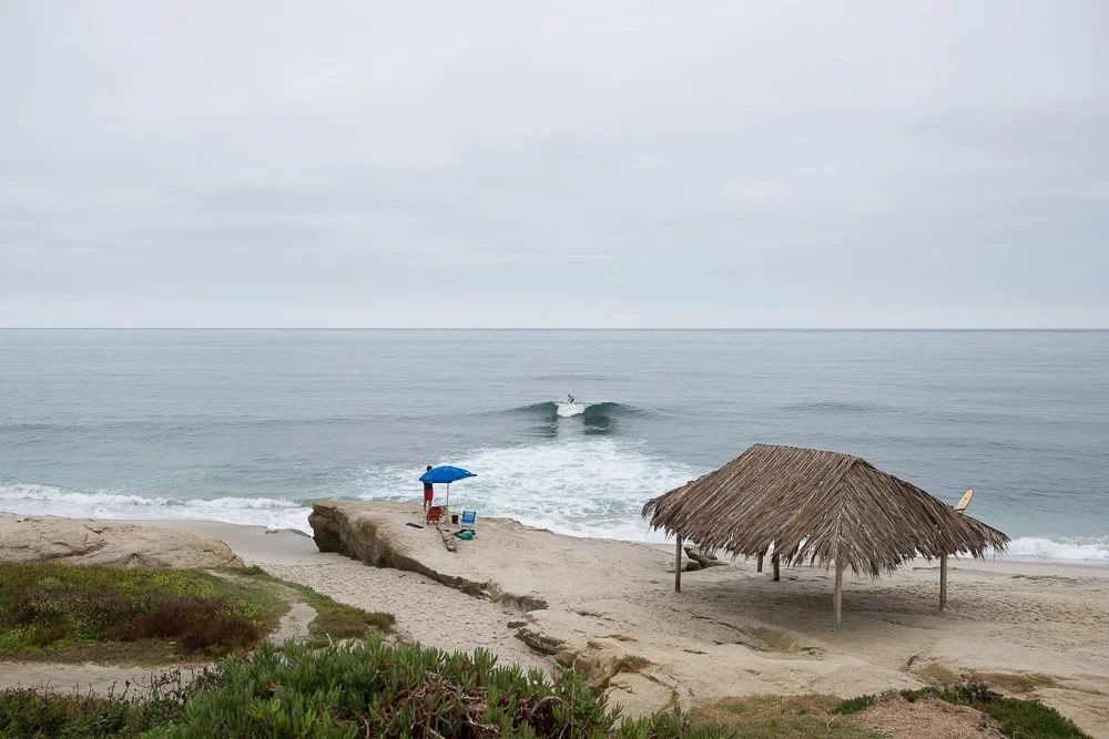
The short exposure for my “All mine!” photo with the surfer on the wave
So my first two photos I ever took at Windansea Beach resulted in this after I combined them later at home:
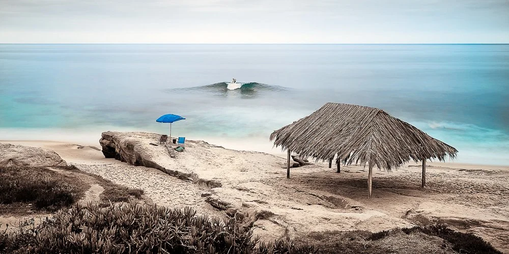
All Mine!
and called it “All Mine!”.
After these shots I captured a whole bunch more, including “To Windansea” which appeared on the cover of L’Chaim magazine in September 2024.
“To Windansea”
“All Mine!” turned out to be one of my best selling images and it sold out 5 years later. I only kept two Artist’s Proofs, one at 12x24 inches and one at 30x60 inches. Last month I decided to embed the 12x24” print that is printed on Fuji Crystal Archive Pearl Photo Paper in resin.
“All Mine!” Artist’s Proof embedded in resin.
All Mine! The Way It Should Be
In September of 2023 I was thinking about what new piece I could take to the La Jolla Art and Wine Festival the next month. I was thinking of “All Mine!” but wanted to prevent creating something that looks too similar. I have had a drone (named Rolf) for a while and then it came to me: I could have the shack in it again, plus a single surfer on a single wave, but looking back from the ocean towards land.
After parking my car on Nautilus Street I walked over to the shack and took Rolf out of the bag. All the conditions were good to fly a drone. After some initial stills and videos I flew Rolf out far enough beyond where this iconic wave always breaks more or less in the same way (surfers have told me there is a little reef there that makes the wave break predictably), and pointed him back to land.
A surfer that I caught with my drone.
I took a photo with the wide angle lens. It didn’t quite look the way I wanted it. The shack and surfers were too small in the frame.
The view of the Windansea Beach coast with the wide angle lens on my drone.
Fortunately, my drone has two cameras, a wide angle and a telelens.
So I got another shot with the telelens. That was much better as the surfer was a good size, but the shack was just outside the frame.
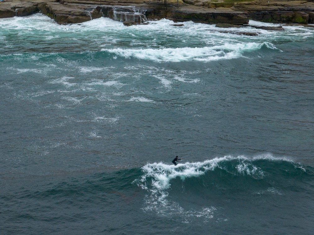
A surfer on the wave at Windansea Beach that I caught with the tele-lens on my drone.
Since I cannot take a vertically oriented photo with Rolf I captured a few more photos from shack to sky and stitched them all together later resulting in this:
The final assembled shot.
That’s exactly what I was going for.
Now it still needed a title. I thought of “All Mine! II”, but set aside that pretty quickly. I don’t quite remember but it was probably my wife who came up with the original “All Mine!” as she often comes up with better titles than I do.
One time while she was on the phone with her business partner we texted her the new image. She called her husband - who is a surfer - and we told them that the first image was called “All Mine!”. “And that’s the way it supposed to be!” he blurted out on the other side of the line. Now, the image was complete.
Since then I have hand colored black and white versions of it at various sizes.

“All Mine! The Way It Should Be” in black and white on 40”x60” canvas, hand colored with oils
Before the Farewell: Documenting the Ocean Beach Pier in Unprecedented Detail
Before the Farewell: Documenting the Ocean Beach Pier in Unprecedented Detail
4.7 Billion Pixels of History
4.7 Billion Pixels of History
The 57 year-old Ocean Beach Pier in San Diego, California has been closed since October 2023 after a series of storms damaged it significantly.
The Ocean Beach Pier
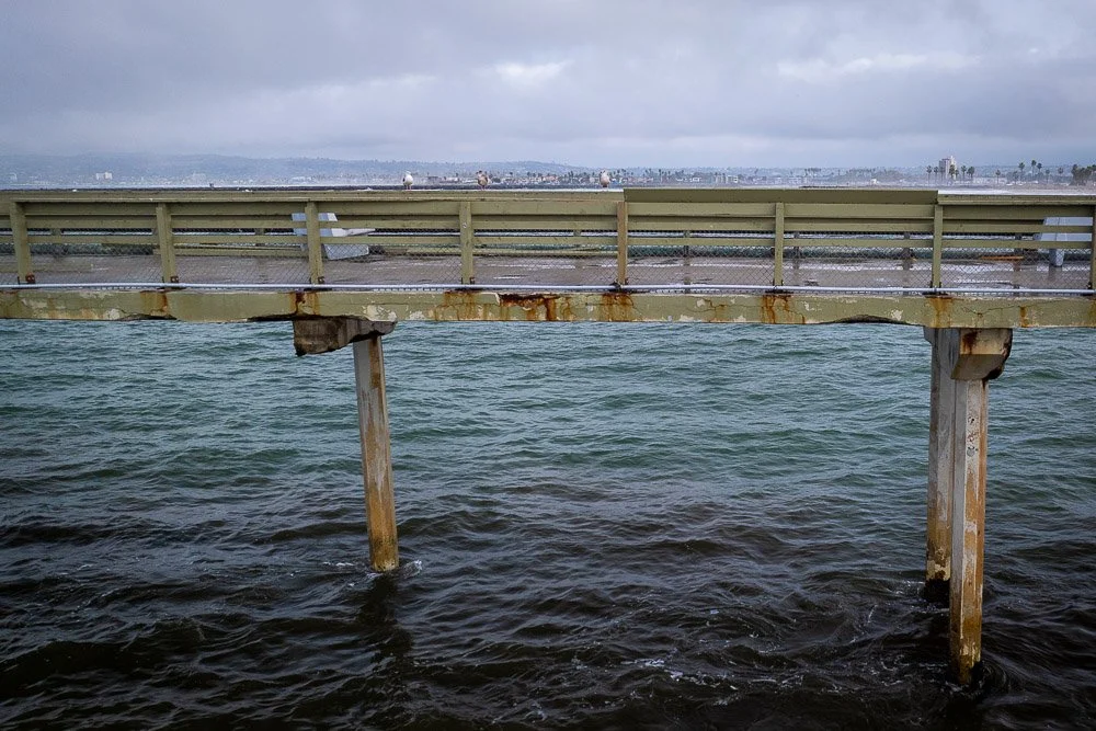
One pillar is missing (and I believe since then more)

railings are broken

and floor plates which connects parts of the pier are loose
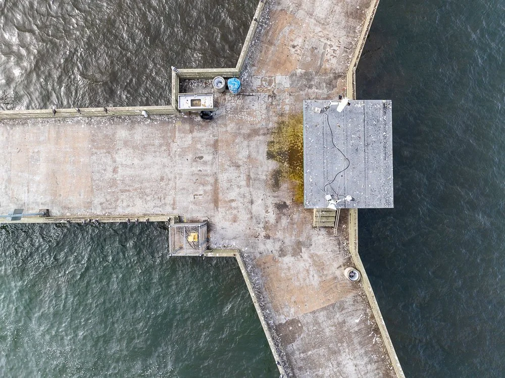
The news is that the pier is going to be replaced and a new design has already been circulated. With many committees involved it probably is going to take years, even till the pier is going to be demolished.
So before the pier is gone I wanted to capture it. Not only did I want to take several shots of it from a variety of perspectives with my drone, I was curious if I could capture it in very high detail viewed directly from above.

View of the OB Pier from the west
The pier extends 1971 feet into the ocean. The wide-angle lens on my drone has a field of view angle of 82 degrees. That means I’d have to be at an altitude of about 2300 feet with some room to spare to capture it fully in one shot.
The maximum legal altitude of a drone away from airports is 400 feet. But because the pier is more or less in the flight path of San Diego’s airport, a drone’s maximum legal altitude here is only 50 feet.
This is what the pier looks like from 50 feet:
The OB Pier from an altitude of 50 feet
Which is of course a tad short of the whole thing.
Therefore I captured 77 photos of the pier and 31 photos of the nearby coast and stitched them all together.
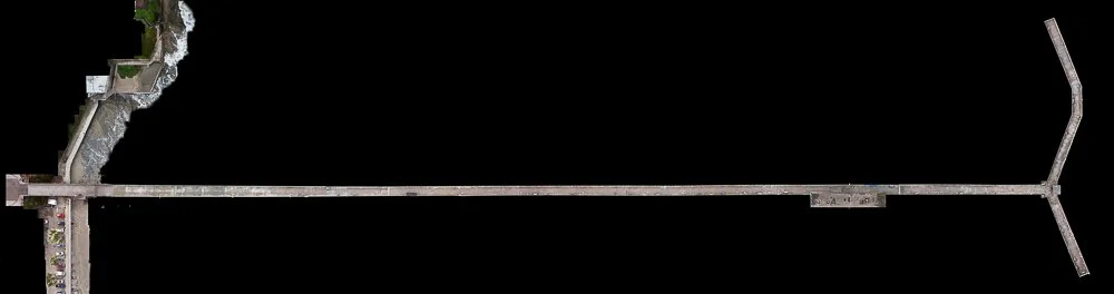
The pier in full without the ocean
But now I only had the pier and the nearby coastline. I also wanted the ocean in the picture and more of the land of Ocean Beach as the pier starts further inland, plus the coast curves towards the ocean south of the pier.
I could have captured the ocean around the pier using the same strategy I captured the pier with, but that would mean hundreds more photos which are difficult to stitch together because of the constant motion of the ocean.
Instead, I went to Pacific Beach near the Crystal Pier where a drone can go up to 400 feet.
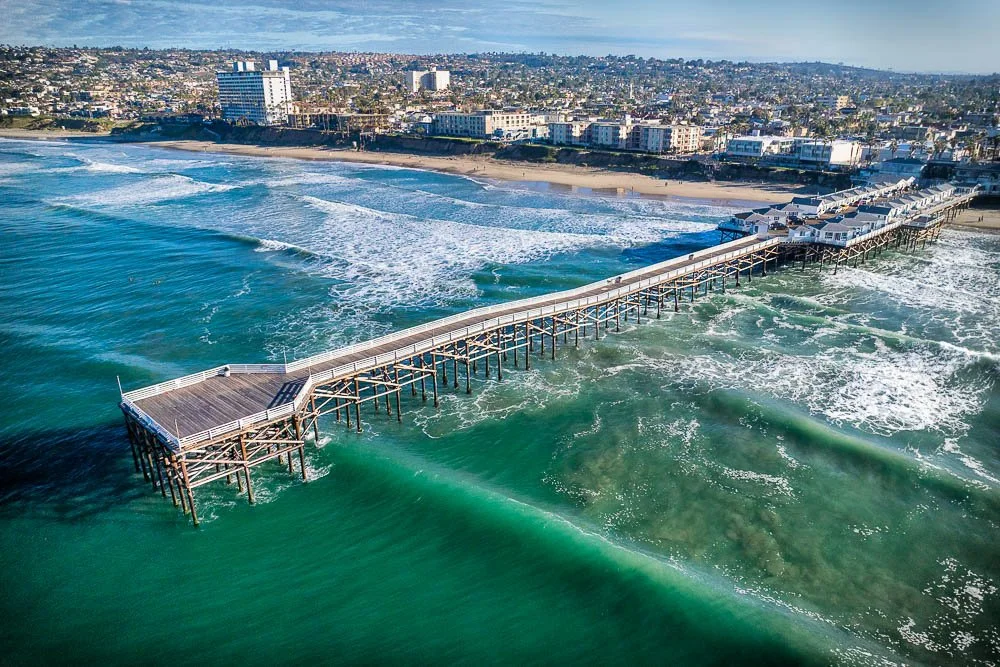
The Crystal Pier in Pacific Beach, San Diego, CA
Here, I captured the ocean in 22 photos from an altitude of around 200 feet. Stitching these by hand was feasible:
The Pacific Ocean just north of the Crystal Pier
and stuck those images under the Ocean Beach Pier:

The image is coming together
But the image is not complete yet: I still had big gaps of Ocean Beach itself. Google Maps or Google Earth is too low resolution to fill in these gaps and I didn’t want to fly my drone above houses and streets at the low altitude of 50 feet.
So I filled in these spots with the help of Photoshop’s Generative Fill, my drone photos from elsewhere and digital painting, and let myself guide by satellite photos from Google Maps:

Now I had a very high resolution image of a damaged and abandoned pier. That is, without people. The pier was full of pigeons, seagulls, cormorants and pelicans.
To bring the pier back to life I cleaned up the boards of the railings that were scattered throughout, put back floor panels that were moved by the storm:
cleaned up the bird poop:
straightened benches, opened the gates and above all, added people all over the pier which included women, men, children, photographers (guess who?) and fisherwomen and - men.
This image contains 4.7 billion pixels, which means it can be printed 74 feet long (on wall paper) without loss of detail.
Here is the final full view:

On my YouTube channel you can see a short video of this project.

The House of the Devil: a Visit to Casa Diablo Mountain
The House of the Devil
A visit to Casa Diablo Mountain
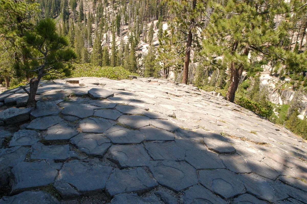
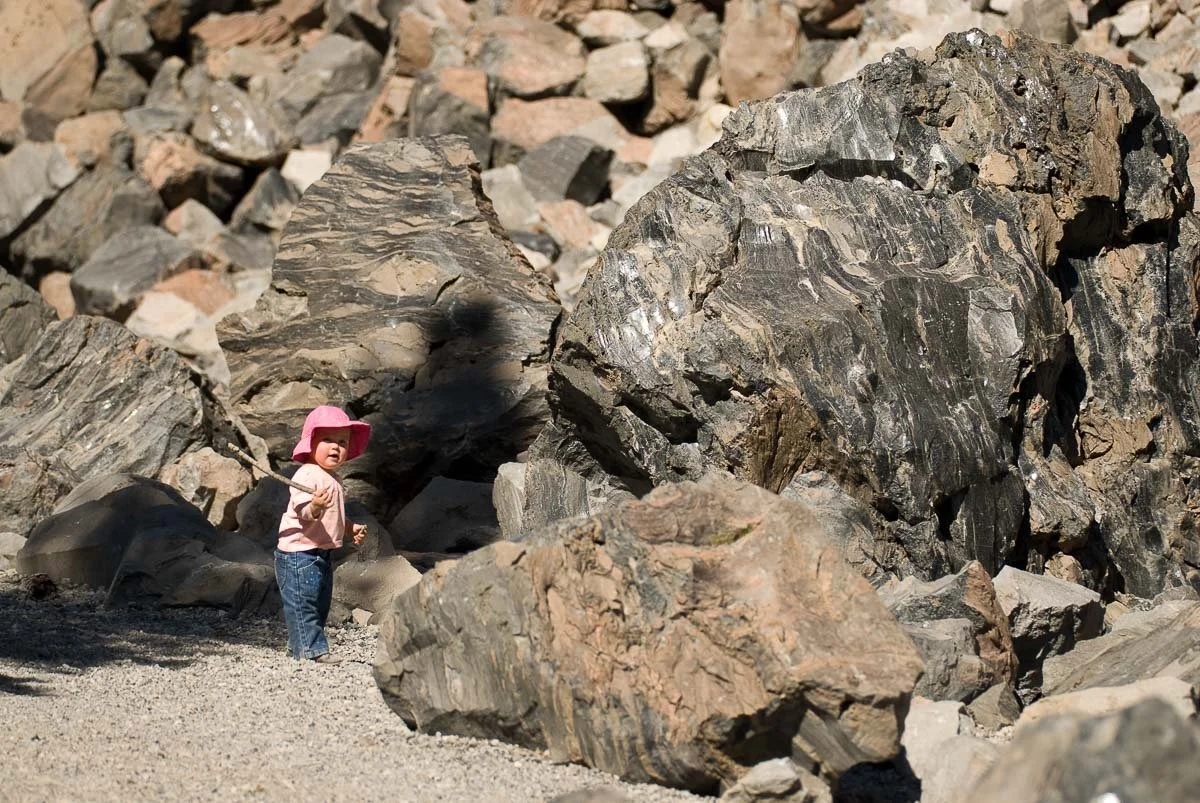
Casa Diablo Mountain is located within the Long Valley Caldera near Mammoth Lakes, California. It consists of giant boulders that remind me of the boulders at Joshua Tree National Park. Just like Joshua Tree National Park Casa Diablo Mountain is a popular spot for rock climbers.
Casa Diablo Mountain as seen from the Buttermilks
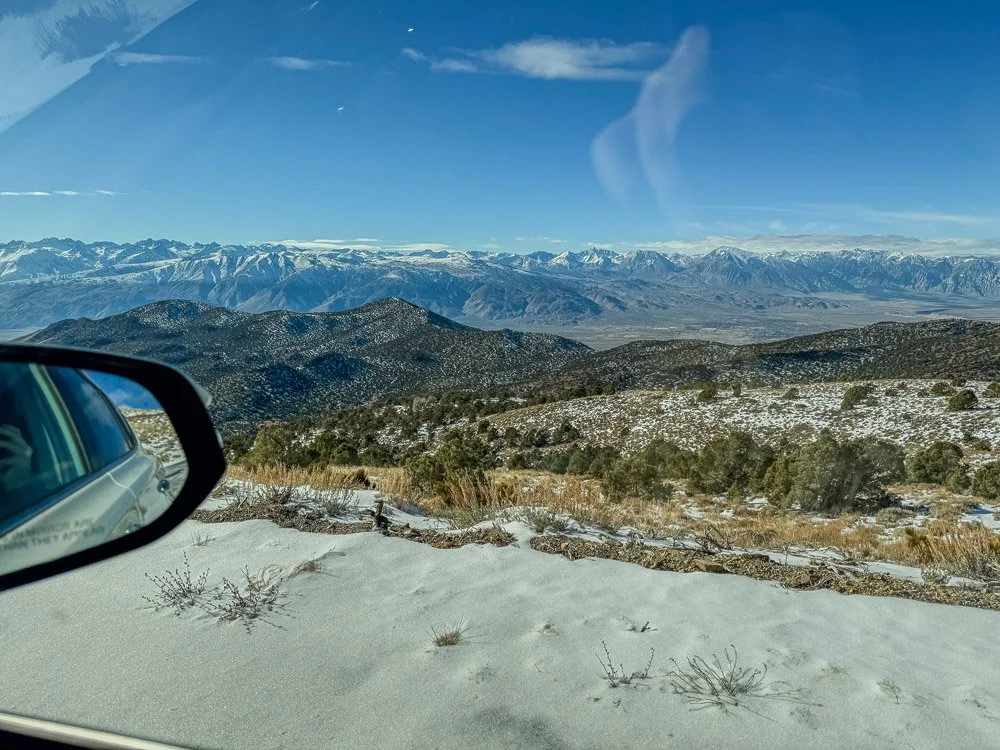
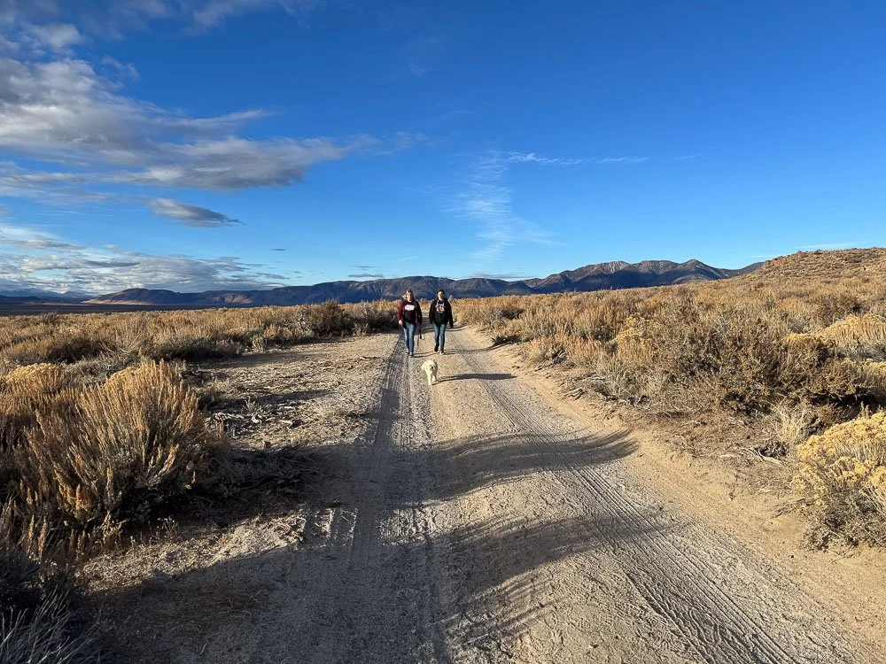
We - my wife, daughter, brother-in-law and I - visited it near sunset after our visit to the stone columns at Crowley Lake, only a couple of miles away. Most of the roads here are unpaved and several roads lead to the foot of the mountain. At some point we had to turn around and find another way because the road was too narrow while all kinds of bushes were scratching the side of our RAV4.
The tiny white dot at about 1/3 from the right and bottom is our car. The snow-capped peaks of the Eastern Sierra dominate the background
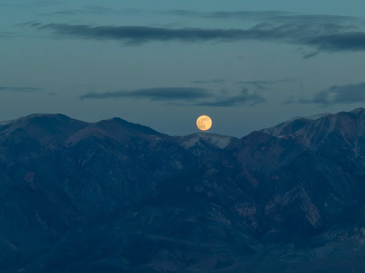
We did find a better path and parked as close as we could get to it on the west side. Nobody else was around. Because it was getting colder my wife and daughter decided to stay in the car, while my brother-in-law and I took out Rolf, my drone.
I flew towards the mountain and when I rose above it, a beautiful rising full moon revealed itself over the White Mountain range in the east:
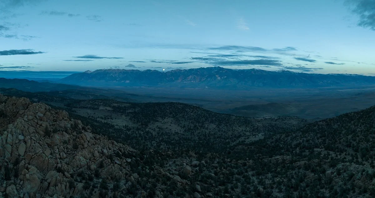
Full moon over the White Mountain range from Casa Diablo Mountain
As my DJI Mavic 3 drone has two cameras, I also captured a close up of the moon over the mountain range:
A full moon that just arose over the White Mountain range
And here is a shot of the moon taken between the two peaks of Casa Diablo Mountain:
The full moon between the two Casa Diablo Mountain peaks
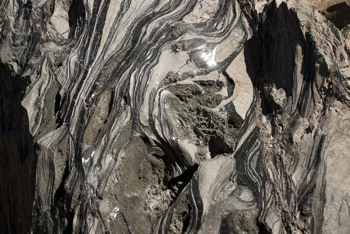
Before our trip back to Bishop, I took a shot of the tallest peak of Casa Diablo Mountain, while looking straight down. This shows the massive size of the boulders:
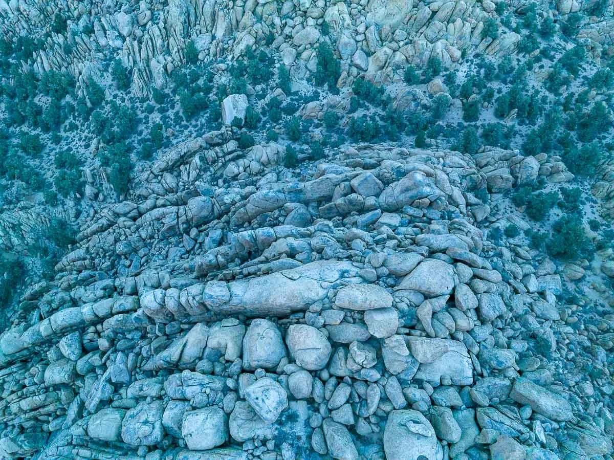
The massive boulders on Casa Diablo Mountain
Here, Rolf was about 400 feet above the peak. The green splotches near the top of the photo are pine trees and they (plus the altitude Rolf was at) give a good sense of the massiveness of the boulders.
The drive back to town was quite uneventful, although it was a bit of a challenge driving in the dark on an unpaved road that had some rain damage.
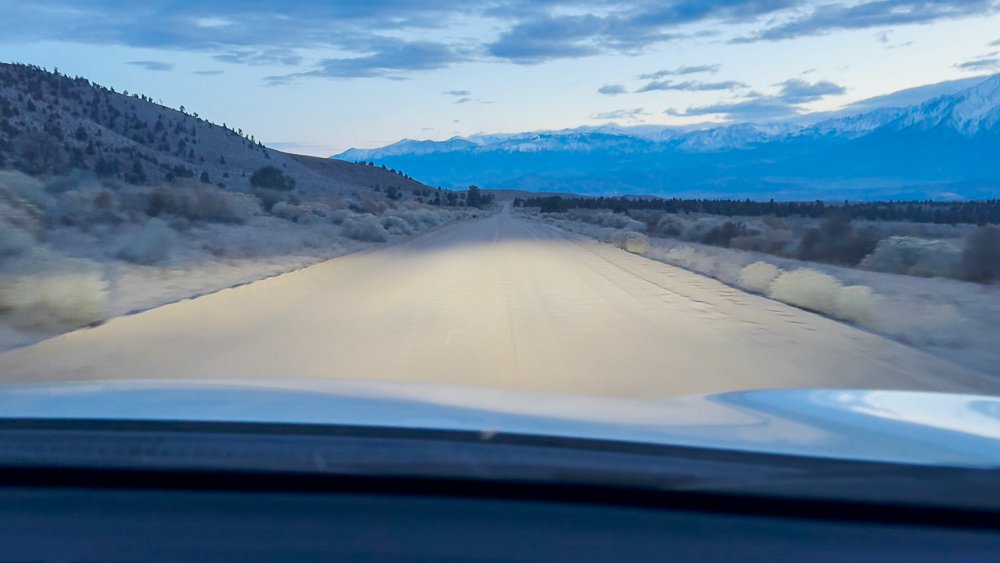
Our drive back to Bishop
Ancient Trees on Snow Covered Mountains
Ancient Trees on Snow Covered Mountains
A visit to Bristlepine Cone Forest near Bishop, California
A Visit to Bristlecone Pine Forest
Some of the oldest trees in the world are located at Bristlecone Pine Forest in the White Mountain range on the east side of Owens Valley near Bishop, California. These beautiful gnarly looking pines are over 4,000 years old, with the oldest tree dated near 5000 years. That’s old.
My wife and I first visited the area in the summer of 2006. I wanted to capture some cool sunrise photos with the trees, so we stayed overnight in Big Pine, CA, from where the road leads to the forest. We got up super early so we would get there before first light. It was interesting driving the unpaved roads in the dark, but we arrived safely and settled at a particular spot so I could catch the sun rising above the Great Basin of Nevada.
A Bristlecone Pine at sunrise

The sun peeking over the mountains at Bristlecone Pine Forest
While the sun rose higher in the sky I also acquired some close-up shots of the beautiful bark. Parts of these trees die while other parts keep growing giving them a very distinct look.

A typical Bristlecone Pine
Bristlecone Pines in a barren landscape at about 11,000 feet elevation
We wanted to visit the forest more often, but each time we visited Bishop and Mammoth, it was mostly in winter times. My wife used to snowboard and I skied. And when I was there for the Mammoth 4th of July art show, I had my big van with me and didn’t feel like it taking it up in the mountains.
The roads to and within Bristlecone Pine Forest are not cleared of snow and they are closed for safety. In December of 2023 we visited the area again and pessimistically we checked if the forest was accessible. It was! We were excited as we also had our daughter Kate with us this time, my wife’s brother Bob and two little dogs. It was going to be another inspiring trip, with a little more unsuspected adventure, all on Christmas Day.
A winding road (CA-168) leads from the US-395 in Big Pine up into the mountains till you take the turnoff for the forest. This road becomes unpaved but is still very drivable. Now and then beautiful views of the Owens Valley opened up to our left.
The winding road with increasing amount of snow in Bristlecone Pine Forest
We were ascending further and further until the first blobs of snow appeared on the side of the road. The amount of snow on the ground increased steadily until it was covering everything, including the road. It wasn’t too thick though and I was able to stay in previously created tire tracks.
We stopped at the Sierra View Overlook view point which provided magnificent views over Owens Valley and the snow covered slopes of the Eastern Sierra Nevada on the other side of the valley.

View of Owens Valley with Bishop and Eastern Sierra slopes
Back on the road, the amount of snow kept increasing. We were in a Toyota RAV4, which has 4-wheel drive and not all-too-bad clearance, although I wouldn’t say that it has the properties of say a Nissan XTerra. And we did bring snow chains.
We were getting closer to the Visitor Center at Methuselah Grove but now the snow was getting much higher with some tracks that only provided pretty much one lane. A much more seriously looking all wheel drive was parked on the other side of the road and the driver of that car had a look on his face that said “What are you doing here?”.
From here the road went downhill and in the distance we could see the Visitor Center. There were no other cars and the tracks in the deep snow were telling us that maybe one or two cars had been here before us. The parking lot was unrecognizable and I just parked the car where I thought there was parking. In deep snow that is. My brother-in-law said to keep the wheels straight so if we had to we could put on the snow chains later.

Our RAV4 parked in the snow
It was windy and freezing and nobody else was around. We walked around a bit into Methuselah Grove and back to the car. Around us, the Bristlecone Pines were very recognizable.
A Bristlecone Pine in the snow in Methuselah Grove
While my family went on another trail, I took out Rolf - my DJI Mavic 3 drone that my wife refuses to refer to as Rolf - and cleared a spot from snow on a picnic table for a takeoff point. I captured some photos and videos of some of the trees and acquired wide angle views of the area, plus I also took a “spherical” photo from above the visitor center, which provides the ultimate wide-angle view of the whole area.

The view towards Death Valley
When my family came back my wife and daughter got in the car and Bob was going to direct me getting out of there. The car hardly moved. We were stuck in the snow. I was able to drive in reverse a little bit and Bob was going to help push the car. That worked. I was able to drive perhaps 200 feet until I got stuck again. The snow was still deep here with hardly any tracks in it. He pushed again and I drove till the tracks in the snow became more substantial. He stepped in the car and we were on our way.
The access road to the bristlecone pine forest visitor center covered in snow
It’s quite the experience driving on a snow-covered road with a deep canyon to your right.

The windy road with beautiful views
The view from our car driving back from the bristlecone pine forest
When we were approaching a left-leaning curve that I couldn’t see beyond I said “I hope we don’t encounter another car here”. And of course, a Tesla came around the corner. A Tesla! One of those low ones! I know most are all wheel drive but the clearance on this one is virtually non-existent. Anyway, we passed each other no problem while we gave it a look that said “What are you doing here?”.
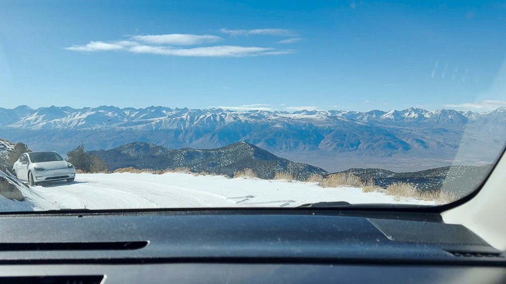
The Tesla approaching us on a narrow snow covered road
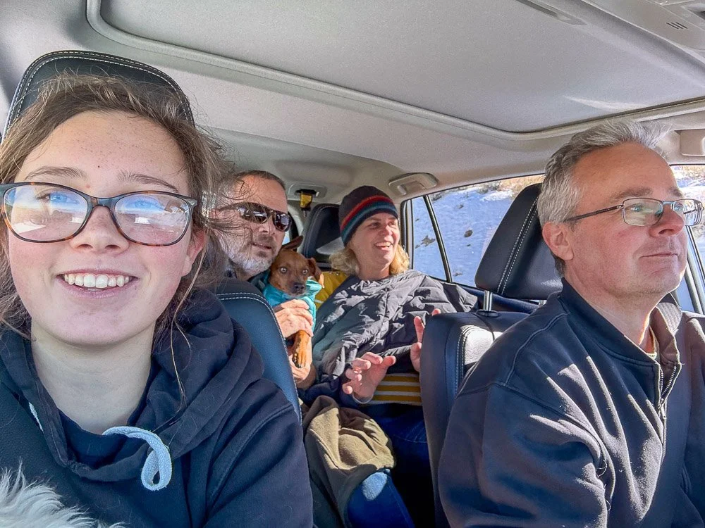
Kate was in the front passenger seat and took a selfie of all of us.
The selfie
We stopped again at the Sierra View Overlook we visited earlier and walked a little further out over a narrow ridge that had some benches with more awesome views.

Our group taking in the views from the Sierra View Overlook
This day was one of the most adventurous Christmas Days we had experienced. I had a hard time writing a final paragraph for this blog, so I asked Google Bard to write the concluding paragraph in Shakespeare style. This is what it came up with:
“From Bristlecone's gnarled embrace we bid adieu, where time itself doth slumber 'neath the boughs. Our steeds of iron, champing 'gainst the breeze, did cleave a path through valleys carved by fire. Volcanic monoliths, like titans slumbering, cast monstrous shadows o'er the sun-baked earth. And so, with each turn of wheel, the vista changed, a Shakespearean drama writ in rock and sky. Until, at journey's end, did Bishop rise, a haven nestled 'gainst the mountains bold, where weary travelers, like ourselves, might find solace and stories yet untold.”
Ancient Temples in the Sierra Nevada?
Ancient Temples in the Sierra Nevada?
The Stone Columns at Crowley Lake
The Stone Columns at Crowley Lake
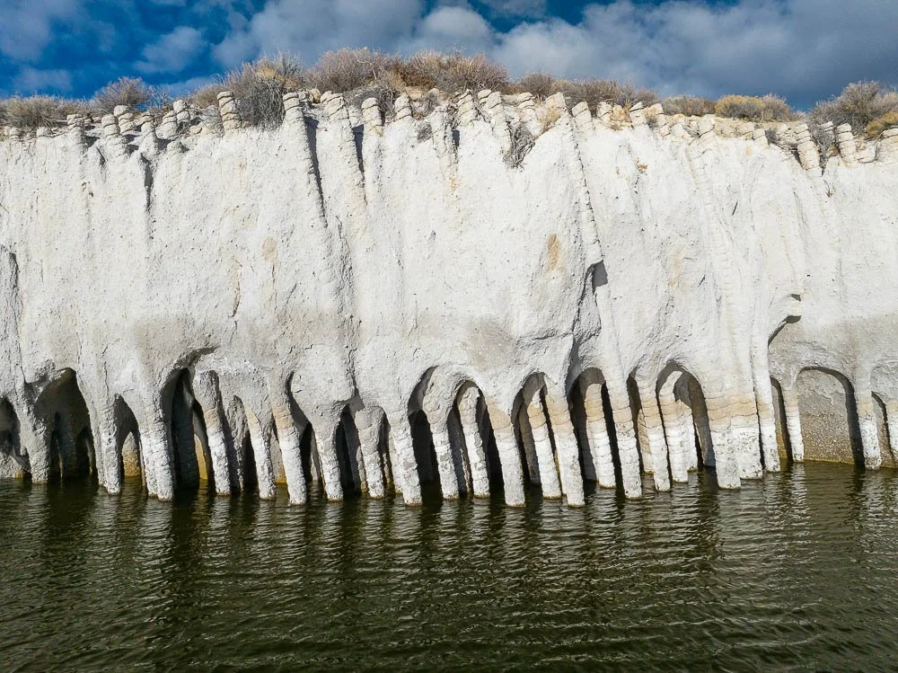
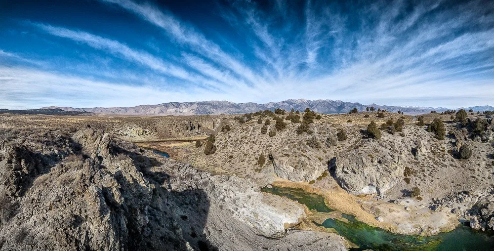
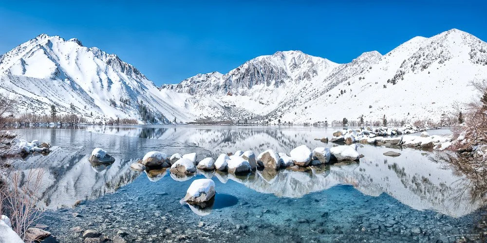
A Naturally formed columns, located on the east side of Crowley Lake, near Mammoth Lakes, California, look like pillars of an ancient temple. Indeed, they have been compared to the ruins of ancient Moorish temples.
An up-close view of the stone columns submerged in Crowley Lake
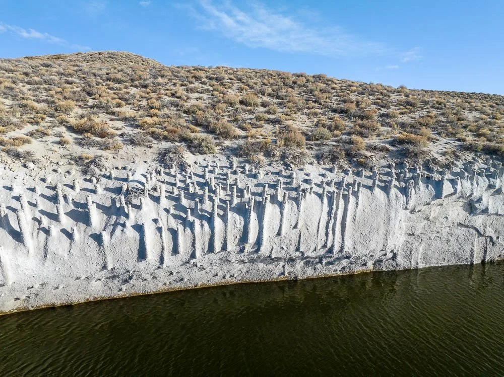
They were formed during a giant volcanic eruption 760,000 years ago that created the Long Valley Caldera, in which Crowley Lake sits. Snowmelt seeped into the hot ash that came from the eruption, causing the water to boil. This created convection cells similar to heat pipes. These pipes were then filled with minerals and over time the rest of the ash eroded away, leaving the columns exposed. They were only discovered in 1941 after the completion of the Crowley Lake reservoir. The pounding of the lake’s water against the shores have exposed more columns. Now there are about 5000 columns and many more are probably still buried.
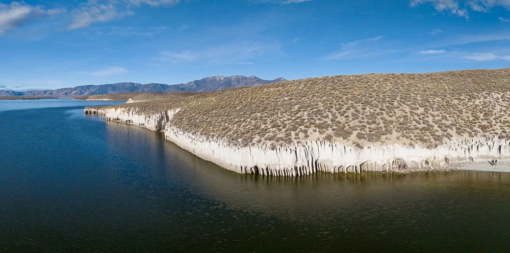
Lots of columns dot the eastern shore of Crowley Lake
The little hike to the columns offers some great views of the lake and the Sierra mountains behind it. The walk down to - and especially getting back up from - the columns at the lake is rather steep and strenuous. We ended up at a little secluded beach where you can check out the columns up-close.
It's a pleasant hike to the columns from the trial head where you can park the car
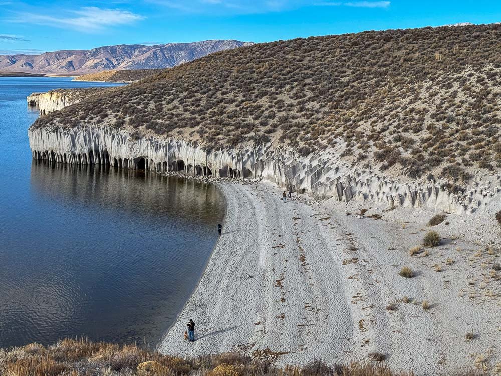
The view when you approach the small beach
Unless you have a high-clearance 4-wheel drive I recommend parking at the Trail Head for Crowley Lake Stone Columns. You can get pretty close to the stone columns with said car, but while we parked at the lot and started walking, we saw a few cars having some trouble getting out of there. From the trail head it’s an about 2-mile walk to the columns. Or, you can get there by boat from the other side of the lake.
The magnificent peaks of the Sierra Nevada beyond Crowley Lake
It amazes me that even though I have visited the area for almost 20 years now, there is still so much to discover in this volcanically active area of the Eastern Sierra Nevada.
Lots of columns are still buried in the rhyolite ashes

Scalding Hot Water from the Earth: a Visit to Hot Creek
Scalding Hot Water from the Earth
A visit to Hot Creek near Mammoth Lakes, California
As soon as Mammoth Creek - fed by snowmelt from Twin Lakes - in California flows under the US-395 its name changes to Hot Creek, joins Owens River and flows into Crowley Lake. The Hot Creek Geological Site is located a few miles north of the Mammoth Yosemite Airport. An unpaved roads lead to this spot with near-boiling water coming out of the earth.
Hot Creek near Mammoth Lakes, California with Glass Mountain in the background
This site is located within the Long Valley Caldera which was formed 760,000 years ago by a giant volcanic explosion and followed by (lesser violent) volcanic eruptions, the last one a few hundred years ago.
The thermal springs in Hot Creek are fed by Sierra Nevada snowmelt that seeps underground and flows eastward, reaching temperatures as high as 428°F (220°C) in the vicinity of magma beneath the caldera. As the water moves towards the springs at Hot Creek the temperature at which water emerges can be close to boiling.

View towards the Eastern Sierra range above Hot Creek
People used to bathe in the warm/hot waters (including myself a long time ago), but the water temperature over time changed a lot and at times got so hot that people were getting scalded and swimming was prohibited since 2006. You can still walk the area, but some areas are also fenced off because of sudden geyser activity.
The second time we (my wife, brother-in-law, daughter and two dogs) visited in December of 2023 I also brought my drone to create some videos and photos that obviously cannot be acquired with my hand-held camera.
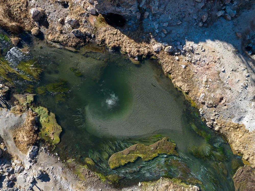
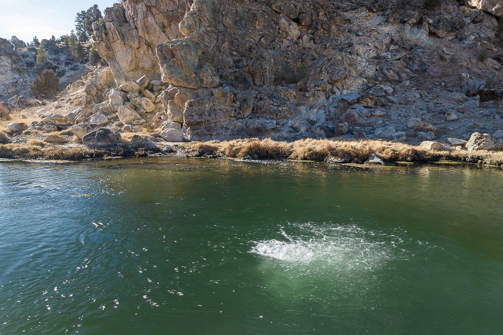
While we were walking down into the canyon you could already see water and gas bubbling up from a spot in the middle of the creek and water vapor rising from natural pools flanking the creek. These pools contain beautiful blue water that is caused by dissolved minerals in the water, the lining of minerals in the pool walls and the high temperatures as most bacteria and algae cannot live here (which normally gives a greener tint to water).
Bubbling water in Hot Creek
When we got down to creek level, my family went for a walk along the creek and I took out Rolf, a DJI Mavic 3. In this area, you can fly up to 100 feet above ground level with LAANC approval. First I wanted to get a closer look of the bubbling water (most likely carbon monoxide and hydrogen sulfide) and the pools just on the other side of the creek.
A closer look at the spot with bubbles in the middle of Hot Creek
The hot spring pools on the other side of the creek
These pools were used in the 1930’s for bathing, but increased to boiling temperatures in the 1980’s. A fence can still be seen that now runs through a newly created pool that didn’t exist when the fence was built.

A closer look at the steaming hot spring pools with the old fence in the bottom left corner. Click on the image to see it on Fine Art America
I flew my drone over the creek and recorded some footage. A bit to the east I noticed that the creek was a lot wider and beautiful green water plants were performing a gracious dance.
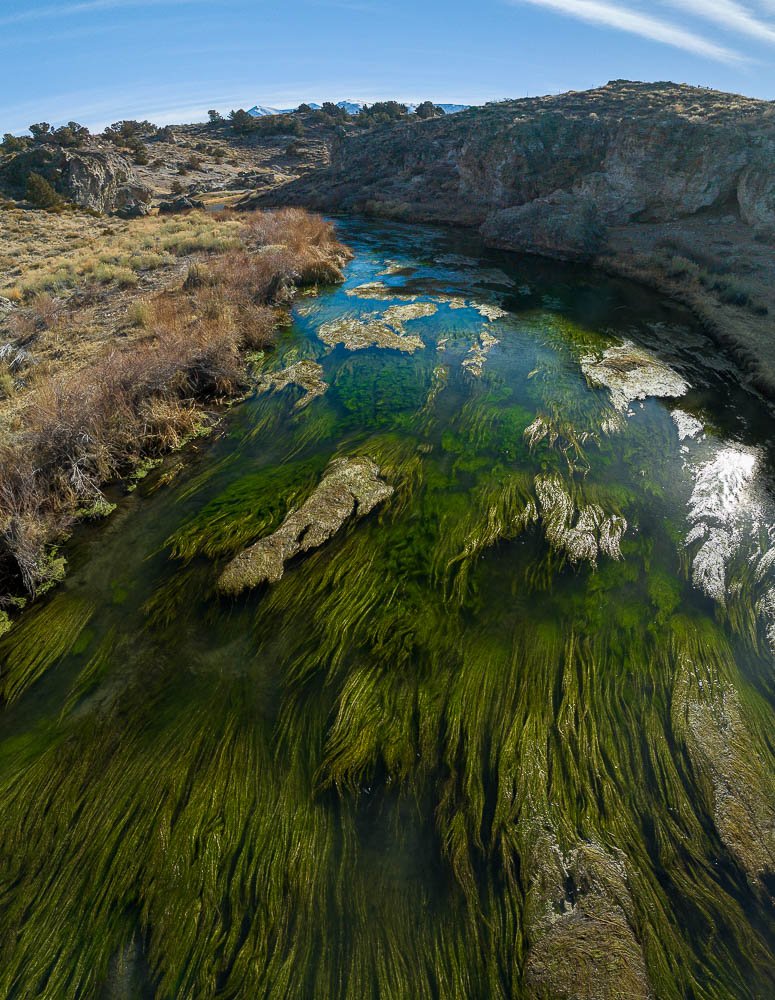
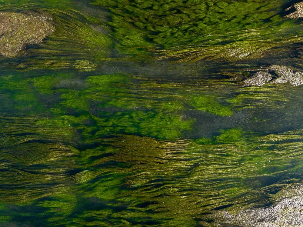
Whirling green water plants in Hot Creek. Click on the images to see them on Fine Art America
I took a lot of photographs looking east and west and stitched together several stacked photos to create some portrait-oriented compositions.

The view above the creek water plants towards Glass Mountain in the north east
I flew back to the pools and acquired photographs from as many angles as I could with the thought in mind to create a 3D model of this area.

The three dimensional model of the Hot Creek hot springs rendered in Blender
I'm not exactly sure yet what to do with the model, but most likely I'll 3D print it and cast it in resin.
I rejoined my family when they returned from their walk, and wrapped up another great day in this beautiful part of California.

The Point Bonita Lighthouse
The Point Bonita Lighthouse. A story of almost getting stuck there.
In July 2016, I wanted to visit the Point Bonita Lighthouse just before I took part in an art show in Silicon Valley. I already visited many places around the Bay Area but this lighthouse was still on my list. However, the hours the lighthouse is open are limited: back in 2016 I believe it was only open 3 days a week and of course I wasn’t there on the right day.
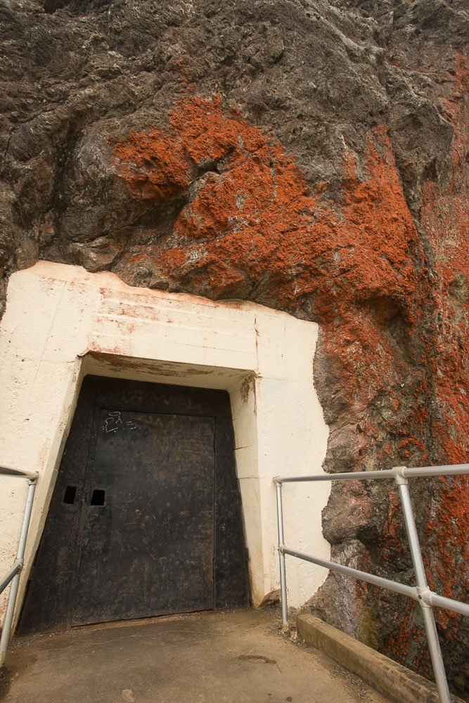
The location of it is intriguing: it sits on a large rock on the north shore of the Golden Gate Strait, barely connected to the mainland. In order to get there, you have to go through a tunnel, carved out of rock, and on the other side is a suspension bridge that leads to the lighthouse. On days the lighthouse is closed, the tunnel has a locked door.
The locked gateway to the lighthouse
Instead of visiting the lighthouse, I walked around the area and got a shot of it from Battery Mendell about half a mile north of the lighthouse.
The Point Bonita Lighthouse in 2016
In March 2023, I went back when the lighthouse was open. I grabbed an Uber from downtown San Francisco and asked the Uber driver if I would be able to get an Uber easily from near the lighthouse and he said “Yeah.” The thing is, the lighthouse is kinda remote and I wasn’t sure about the phone reception there either. It was noon and my plane back to San Diego was leaving at 6:35pm at the Oakland Airport. Arriving at the lighthouse at 12:30pm would allow me plenty of time to take pictures, even walking to other spots in the area, and taking a ride back at around 3:30pm, right?
After the Uber driver dropped me off, I took the trail leading to the lighthouse. In 2016, I took a couple shots of the Golden Gate Bridge from here.

A different view of the Golden Gate Bridge

… and of course a lot of fog
It was more foggy then. Today there was a mix of sunshine, rain, and wind. It had been pouring on and off during the weekend. Now it was sprinkling. In the northwest, dark clouds hung over the ocean and coastline.
This time the tunnel was open.

And at the second attempt the door was open
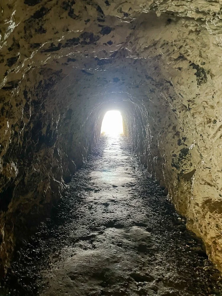
Inside the tunnel leading to the lighthouse
It wasn’t a very long tunnel. Once through the tunnel, the path continued between steep cliffs going down to the ocean and towering rocks. I was walking around a big rock, when I saw the suspension bridge and the lighthouse. I took a few images of them.
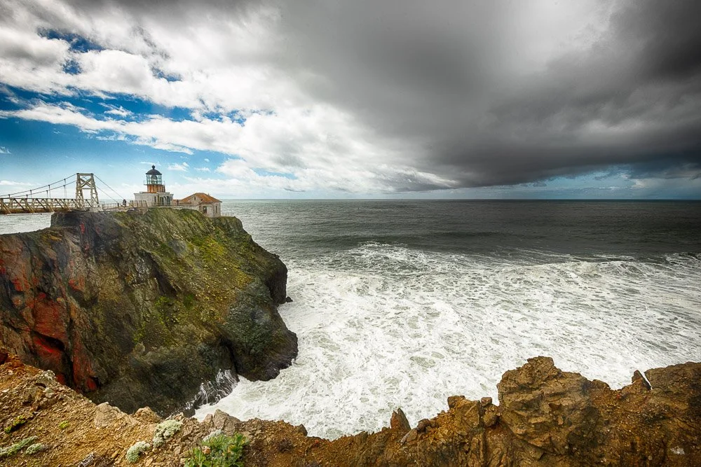
Dark clouds over the Point Bonita Lighthouse
The park ranger was standing at the beginning of the suspension bridge and he told me to be careful: because it had rained, the bridge was slippery and there was a lot of strong wind. I could feel the bridge sway when I went over it.
A park volunteer was waiting on the other side. He told me that the ranger had made a good call to open the lighthouse. It was borderline open: at inclement weather (wind over 30 mph) it wouldn’t have been, but the dark clouds and big waves being swept up by the high winds added to the whole experience. I loved watching and listening to the waves pounding the cliffs at the north end of the islet.

Beautiful big waves pounding the rocks
The lighthouse was built in 1855, a year after the first lighthouse was built on the west coast at Alcatraz Island. Lighthouse caretakers lived in the little dwelling next to the lighthouse till 1986. After that it was automated. You can find more information on the National Park Service website.
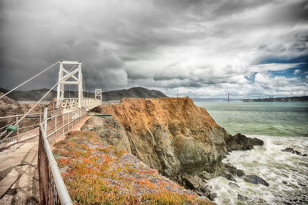
The lighthouse itself sits on a type of strong basalt rock called diabase, which is a greenish color (also called greenstone) and is formed beneath basaltic volcanoes. Since these rocks are formed underwater they form pillow shapes and are also called pillow basalt. There are several natural arches in the area which are great examples of pillow basalt. You can see in the photo toward the east of the lighthouse there is also a brown-orange colored rock, which is also diabase, but more weathered and contains more iron oxide deposits.

The natural arch and suspension bridge at the Point Bonita Lighthouse
I must have been one of the first people to arrive (I found out later that the lighthouse had opened at 12:30pm and not 9:30am as wrongly listed on Google Maps), because I was the only visitor at the time. More people started to show up and after taking lots of pictures I thanked the park ranger and took the trail back north after spending a little more than an hour.
Two suspension bridges. Clicking the image will lead to my prints at mkenvision.com
I walked to the Battery Alexander parking lot and checked how long it would take to get to the Oakland Airport. About an hour. Luckily I had fairly good phone reception, so I had a look at the Uber app to see how long it would take for an Uber to get here. Only 8 minutes. I cooked up a plan to leave here at around 3:30pm so I would arrive 2 hours before my plane left. With an abundance of time available, I decided to visit some of the abandoned batteries (bunkers that used to contain canons) in the area. Many of which have nice views of the Pacific and of Fort Cronkhite down the hill.
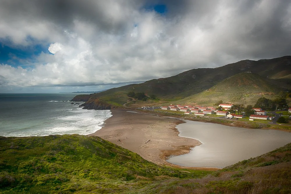
Rodeo Beach and Fort Cronkhite
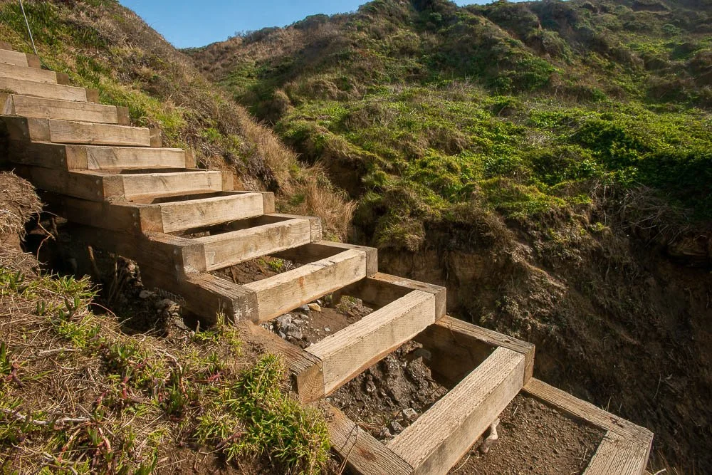
It was 2:45pm when I got back at the Battery Alexander parking lot. I looked to the west and noticed that I could take a trail down to South Rodeo Beach. When I got close to the beach there were some damaged wooden stairs, which were cordoned off with a path leading around it. I thought it looked funny because the stair steps were missing big parts.
Stairs leading down to Rodeo Beach
The beach had very dark sand and the waves were awesome, leaving a lot of foam in their wake. I tried to get some close-up shots of it with buildings at Fort Cronkhite in the far distance in the background.
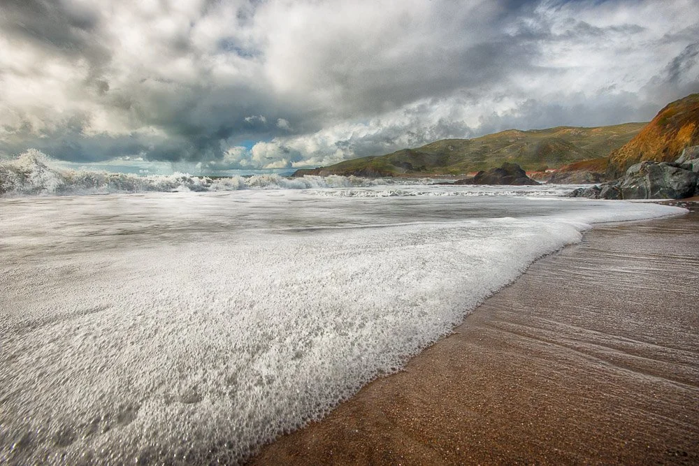
Waves and foam on Rodeo Beach
Now it was 3:15pm. Surprisingly I had reception at this secluded beach. Uber still said it would take 8 minutes for a car to get here. So I ordered one to pick me up at the parking lot up the hill, which was a 8 minute walk. I patted myself on the back for my perfect time management: maximizing the number of photography opportunities and minimizing waiting times.

Rocks and waves at Rodeo Beach
I was huffing and puffing when I arrived at the parking lot. I checked the Uber app to see how far my Uber was. “Finalizing driver details,” it said. Okay, so for the last 8 minutes it hasn’t confirmed a car yet. I waited a little longer when the message “UberX not available at the moment, try another Uber or try again later.” Hmm, I thought, perhaps this parking lot is too remote for drivers and I need to walk to a more populated area.
I started walking north on Field Road while trying again to summon an Uber. Then a red message appeared “Connection to our network lost”. I checked my bars. Zero. When I passed the Nike Missile Site I got back 1 bar and tried again, with a pick up location at the corner of Field Road and Bunker Road. “Confirming pick-up location” it kept saying and nothing else happened.
Reception went in and out and the Uber app never went past “Finalizing Driver Details.” It was 3:45pm when I got to the corner of Bunker and Field Roads where the reception was zero. I could go right, towards the Baker Barry Tunnel (2 miles, 43 minute walk) or to the left, towards Fort Cronkhite. The road to the tunnel leads through a narrow valley and I thought the reception was probably going to be non-existent the whole way. Left turn it is then.
Reception went from 0 to 1 to 0 while I was walking. When I got closer to Fort Cronkhite at Mitchell Road it started raining. Reception was zero and now it was 4pm. Was I going to miss my plane? Would I be able to get out of here at all? At a parking lot at the fort I got 1 bar back.
I was becoming worried but just in case I texted my wife that I may not be able to come back home today. I found some taxi number online and called it. “Sorry we don’t have anyone available right now,” the guy said. I called another number. The taxi guy said that they could have a cab pick me up in about 25 minutes. That would work, that would still get me at the airport at about half an hour before boarding.
I found some shelter against the rain behind a small information sign. My phone rang.
“This is such-and-such taxi company, you called for a taxi?”
“Yes.”
“Well, I am in heavy traffic and I cannot make it there till over an hour.”
“That doesn’t work for me, I would miss my plane.”
“Try such-and-such taxi company,” the guy said.
“Okay, I will, thank you.”
Before I called the other company at 4:15, I tried the Uber app again and chose a pick-up point exactly at where I was standing. I still had that one bar of reception and didn’t dare to move. “Finalizing Driver Details,” it said again. And again. And again… I called another taxi company but the guy on the other side of the phone didn’t know where Fort Cronkhite was. While I was explaining to him where I was, I checked the Uber app and was met with the most beautiful message known to man: “Driver Fred is on his way to the pick-up point” (or something like that). “Never mind,” I said, “somebody is picking me up.”
On the little Uber map, I could see that the car was on the other side of the tunnel at 2.5 miles away and it would take only 9 minutes or so for him to get to me.
After 5 minutes it still said 9 minutes, showing the car on the other side of the tunnel, so I hypothesized. I know reception sucks here so perhaps he is already on this side of the tunnel and the Uber app just doesn’t know that.
That hypothesis was confirmed as I saw a car pull up with the make and license plate number that was listed on the app.
What a relief! When I got in the car I checked traffic and it would take a little over an hour to get to the airport. Luckily, I would arrive still about 30 minutes before boarding.
But then the Uber driver started to get nervous. “I don’t have any reception here,” he said. I told him to just follow Bunker Road east and when you get on the other side of the tunnel you will get reception again. But he kept messing with his phone and mumbling that this drive may not be recorded with Uber. I tried to comfort him; that my app said that I had been picked up, so don’t worry. Now I was worried that he was going to throw me out at some point.
As expected, at the east end of Baker Barry Tunnel everybody got full-on reception again, his app confirmed he was driving me, my app said the same thing, and estimated travel time was now under an hour. We drove over the Golden Gate Bridge, through San Francisco, over the Bay Bridge, over Yerba Buena Island - where by the way I learned earlier at the Point Bonita Lighthouse that this is where the headquarters are of the Vessel Traffic Center that is responsible for the safety of vessel movements in the Bay Area. We drove through Oakland, and into the airport. I made it quickly through TSA and my gate was right on the other side.
I had acquired my photos, some exercise, gained new experiences, and a story to tell. The rest of the trip back to Carlsbad, California, was uneventful.
Finally on my way home
9. Maui's steep cliffs on the way to Haleakalā National Park | Hawaii 2021
9. Maui's steep cliffs on the way to Haleakalā National Park | Hawaii 2021
Day 9
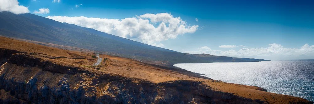
Today we got up relatively early again, so we would arrive not too late at the Pīpīwai Trail in Haleakalā National Park. Because of COVID this part of the park is only open between 9am and 5pm. After that, the plan was to drive to the top of the mountain at Red Hill to see the sunset. I googled directions to the Kīpahulu Visitor Center where the parking lot is. It was a 2:30 hour drive but only 77 miles. Looking at the suggested directions on the map, parts of the route looked very winding.
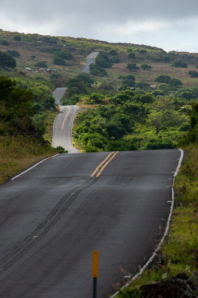
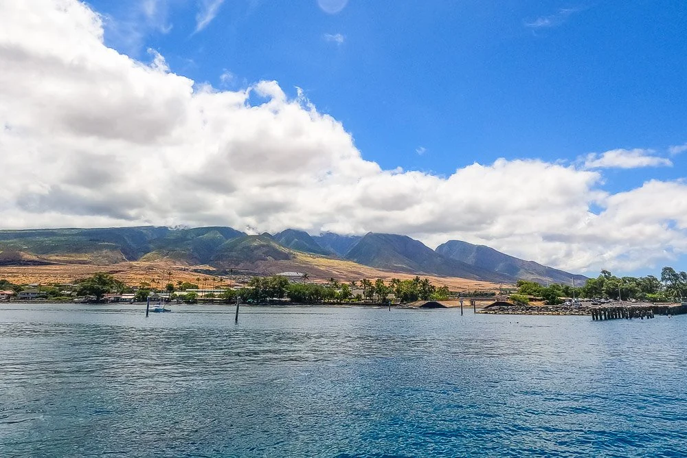
The road at the south east of Maui
Parts of the route we had driven several times already but after about an hour we hit new territory and starting going uphill. Now I understood why it was going to take so long. The speed limit was mostly 25 mph, sometimes 20 and even 10 at very narrow passages. We stopped at a little park that had a view of Molokini, where we snorkeled on day 7.
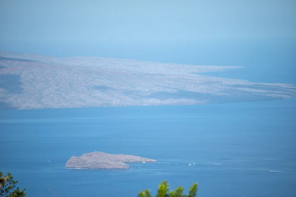
Molokini Crater where we snorkeled on day 7
We took off again and the views were amazing. However, Kate started to feel car sick and asked if we could pull over again. We stopped at a spot with another great ocean and islands view. Animal bones were scattered, well no, placed on rocks here. From now on Kate rode in the front and that helped a bit.
The south east coastline of Maui
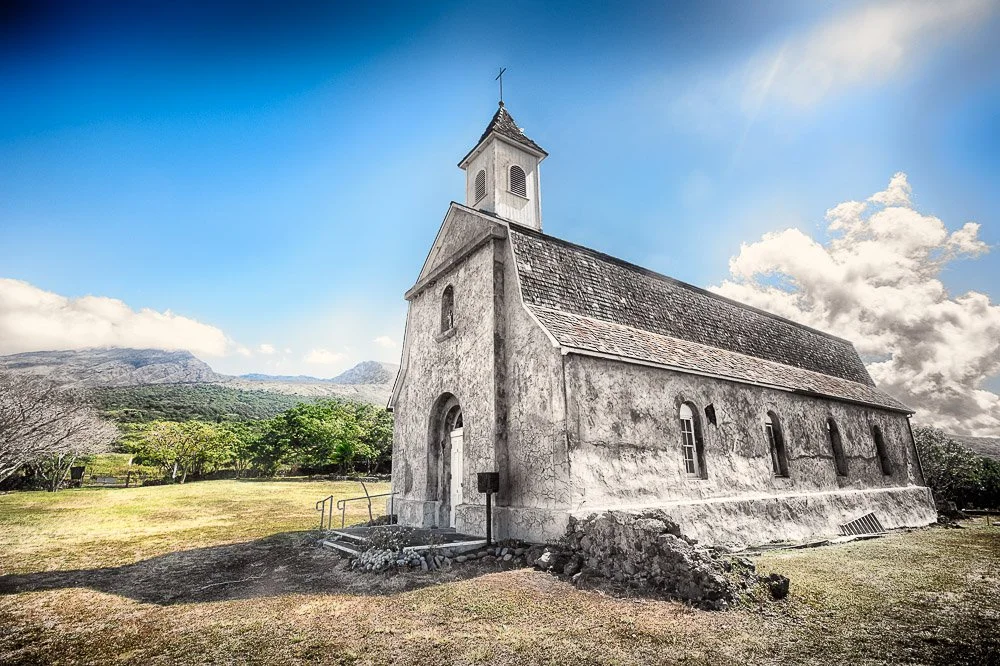
We stopped again at a few places, and one of them was the cutest little church in the middle of nowhere, called St Joseph Church. We walked around a bit and I took some photos of the area.
St. Joseph Church
The road went from paved and two lanes to pretty much one and a half lane to unpaved and rocky. On our left side were towering cliffs and on our right a sheer cliff going straight down. Marie didn’t want to look outside. Now I was doubting if this was the right way. Google probably showed us the fastest, but not necessarily the shortest (or safest) way. We stopped at the end of a super green canyon with a black beach at the ocean. Palm trees with coconuts lined parts of a little pond that was separated from the ocean by a mound of pebbles. A Mercedes Sprinter van approached from where we came from with a line of cars behind it. I couldn’t believe a Sprinter could drive here. When that caravan passed we also hit the road again. There was no reception here but from the last time we did I guessed it was only a couple more miles.
A lush forest
We arrived at the National park booth at 11am, a three and a half our drive (yes we did stop a lot, but that was worth it).
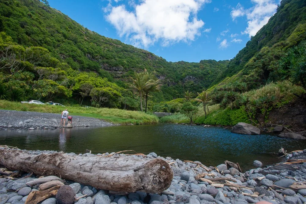
We didn’t bring any food, but did have two water bottles with us. The booth lady said there was no food service in the park. We parked at the visitor center and started our hike at the Pīpīwai Trail. It was a two mile uphill strenuous walk to the Waimoku Falls, with the entrance to the bamboo forest at about halfway.
Water falls and ponds at the Pīpīwai Trail
Initially we were just going for the bamboo forest, but when we got to there we continued for the falls. We passed a beautiful big Banyard tree on the way. It was not an easy climb and I said “I think we are going to die here”, to which Kate replied: “Daddy, if you don’t like dying, we can always go back”.
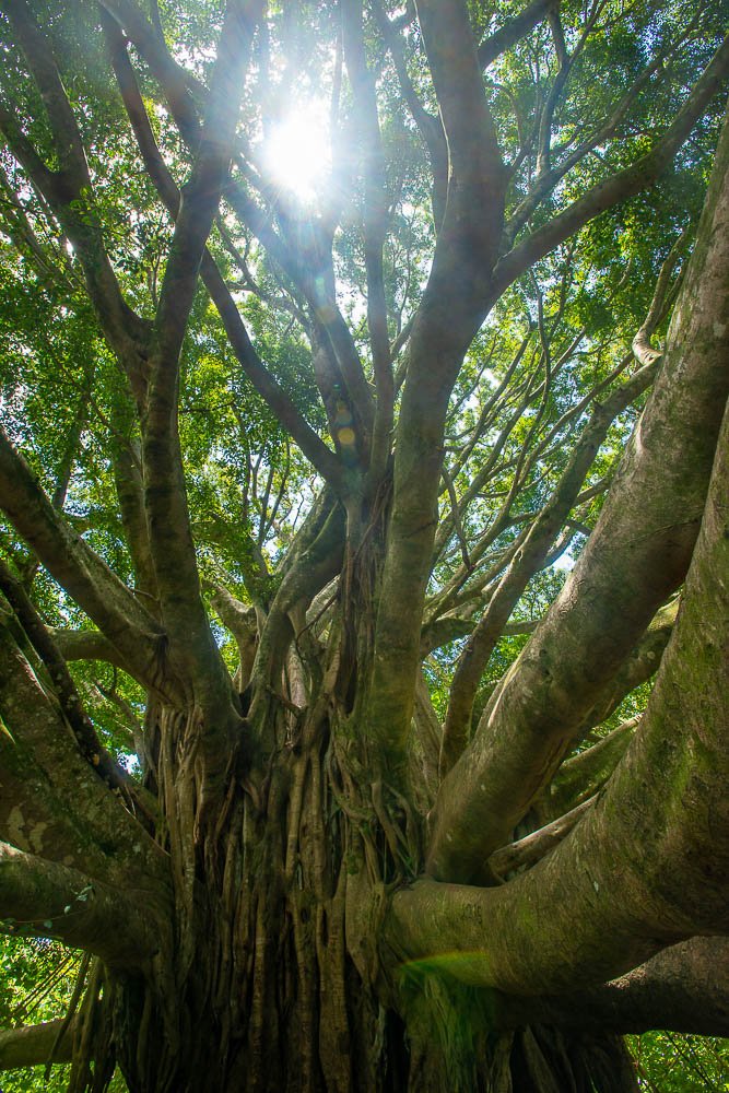
The large banyard tree on the Pīpīwai Trail
The bamboo forest was very pretty, although also controversial as I had just read that bamboo is considered an invasive species here. The rustling of the leaves and the clacking of the sticks touching each other added to the experience.

A path through the bamboo forest
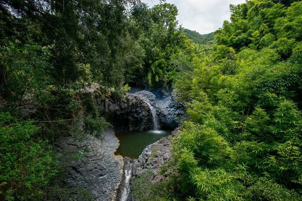
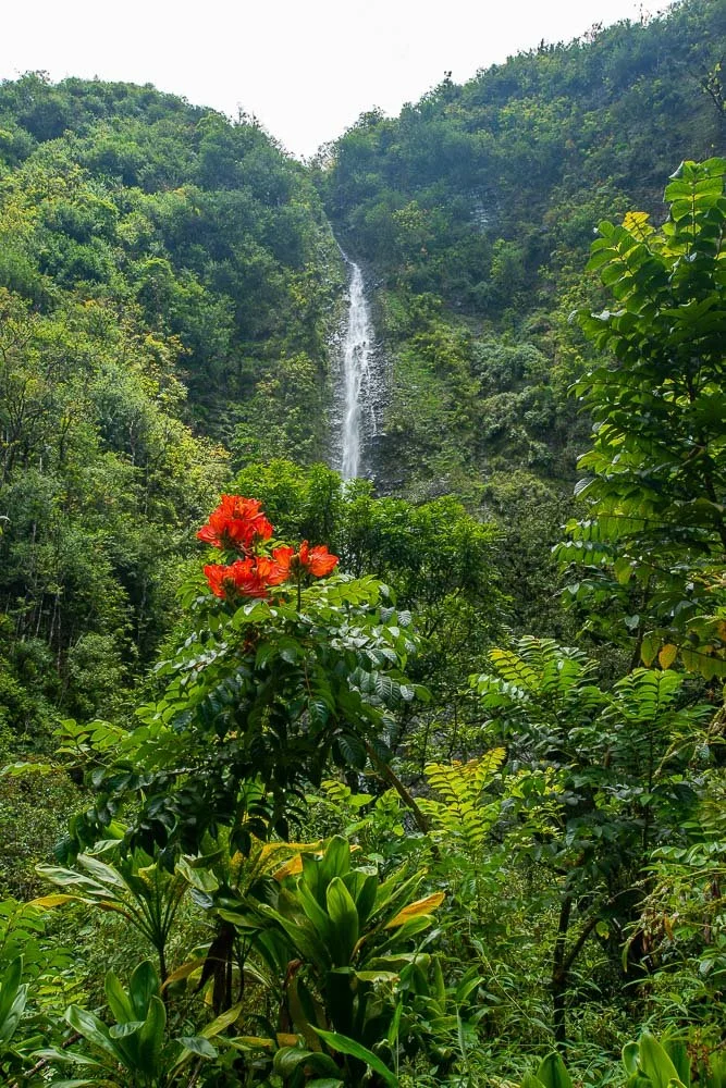
The Waimoku Falls at the end of the trail were also spectacular and I took some photos and videos trying to get some red flowers in there as well.
Waimoku Falls
Marie and Kate were wearing shoes and I was wearing flip flops. It was fine, but I don’t recommend it. All our water was gone by then. We started heading back. Kate said she had a few landmarks in her head that helped her knowing how far we had to go: “the bridges, the big tree, the sign that said “don’t leave for the trail after 3pm, because you won’t make it back before the park closes”, and the road”. The hike back was pretty uneventful and fast for Kate and I. We had gone ahead.
At the water bottle fill station we filled our water bottles. Marie showed up showing pain in her face. She said she had twisted her ankle, needed water and needed to put her leg up. After she drank some, I gave her the car keys and she walked to the car with Kate. I went to the visitor center and asked the ranger if there is another way out. He asked if we had come in on a narrow unpaved rocky road, which I confirmed. “Oh, he said, you came in the back way, now you’ve already seen much of the island”. There was still no reception so we just started driving north east as there was only one “main” road. This (paved) road was still narrow at lots of places, but yield signs were placed at the narrowest spots so cars already there could pass easily. We stopped at “Tony’s Place Hana” and ate lunch.
This route was also beautiful, with lots of green, big trees, ocean views, cliffs and water falls on the way. Kate recorded some videos with the GoPro from the open window. We ditched the idea of driving to the top of the mountain. We were all too tired. We stopped at the Ho'okipa Lookout where we considered driving back to the hotel on the north side of the western part of Maui, but that was another 2 hours, whereas going the normal way at the south end was only one. That means when we got to the point where we entered “new territory” in the morning, it took us about 6.5 hours to drive counter-clockwise around the eastern part of Maui. For 110 miles that is at about 16.9 miles per hour, but with plenty of short stops (not counting the big hike).
This was our last full day on Maui. The next day we headed back to the airport which was also quite the experience. It was so busy that the security line wound back and forth many times. Fortunately we made it all on time and headed back to San Diego with another load of great memories.

US-395: From Southern California to Bodie | Part 2: from Bishop to Bodie
US-395: From Southern California to Bodie
Part 2: From Bishop to Bodie
Our next stop is Bishop, California. You can more or less go directly from the Ancient Bristlecone Pine Forest to Bishop over the Silver Canyon Trail, an unpaved road. But it's highly recommended to take this road only with a four wheel drive with enough clearance (such as a Nissan Xterra). We haven't taken this road ourselves, instead we drove back to Big Pine and from there to Bishop.
Bishop is another cute town with a population of just under 4000 (from the 2020 census) people. It has wonderful views of the mountains around it and has a lot of parks. Many times we stop at Erick Schat's Bakery at 763 N Main St (which is the US-395). The owner, Erick, is from the Netherlands and has lots of different types of breads, pastries and goodies from the Netherlands. Bishop City Park is located on the other side of the road: a nice quiet place to have a walk and through which flows the South Fork Bishop Creek.
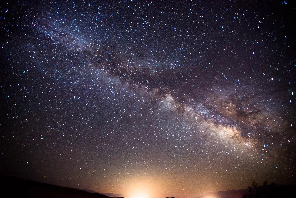
The Milky Way from Paradise, a community north west of Bishop
When we keep going north the US-395 makes a 90 degree turn to the left. But for now we will go straight on the US-6. After about 4 miles we reach the Laws Railroad Museum and Historical Site.
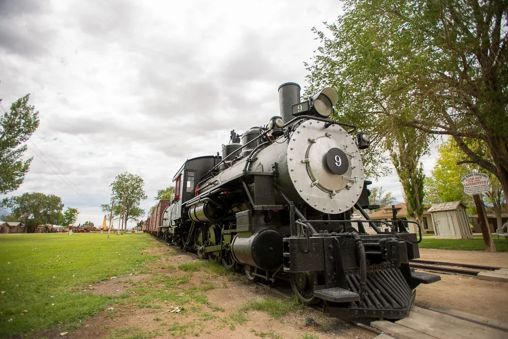
The 1909 Baldwin steam engine
This is a cool museum with 11 acres of indoor and outdoor exhibits, including the old Laws Railroad station and depot, plus a variety of historic buildings from the late 1800's. It was in the doctor's office building when my iPhone thought it recognized a face, whereas there was nobody there.
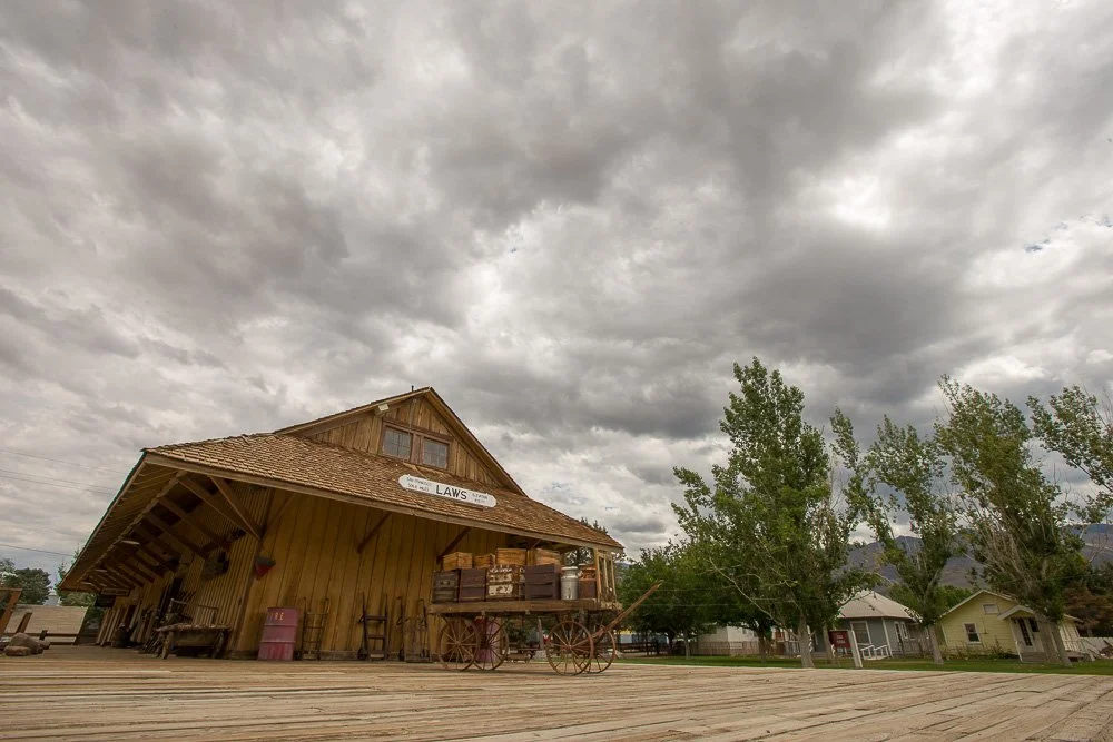
The train depot at the Laws Railroad Museum and Historic Site
When I visited the museum in 2014, they kindly granted my request to enter the General Store (behind the glass). It allowed me to get up and close to the merchandise on the shelves:

An up-close view of the merchandise on the shelves in the General Store
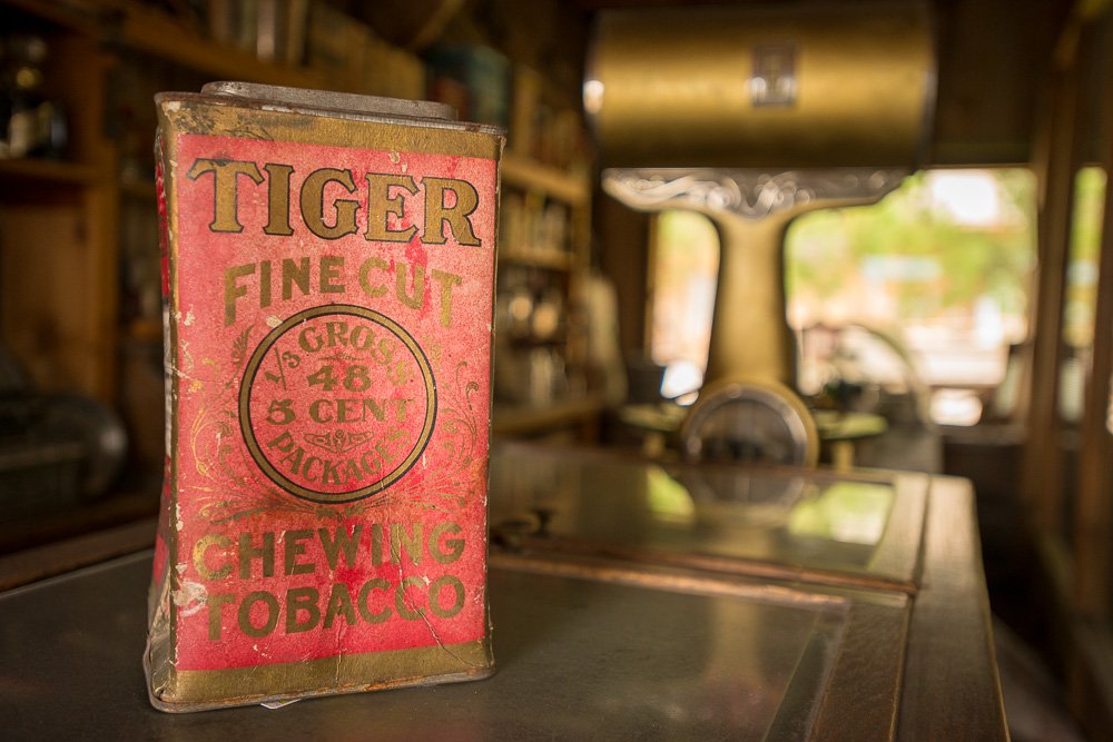
Chewing Tobacco in the General Store
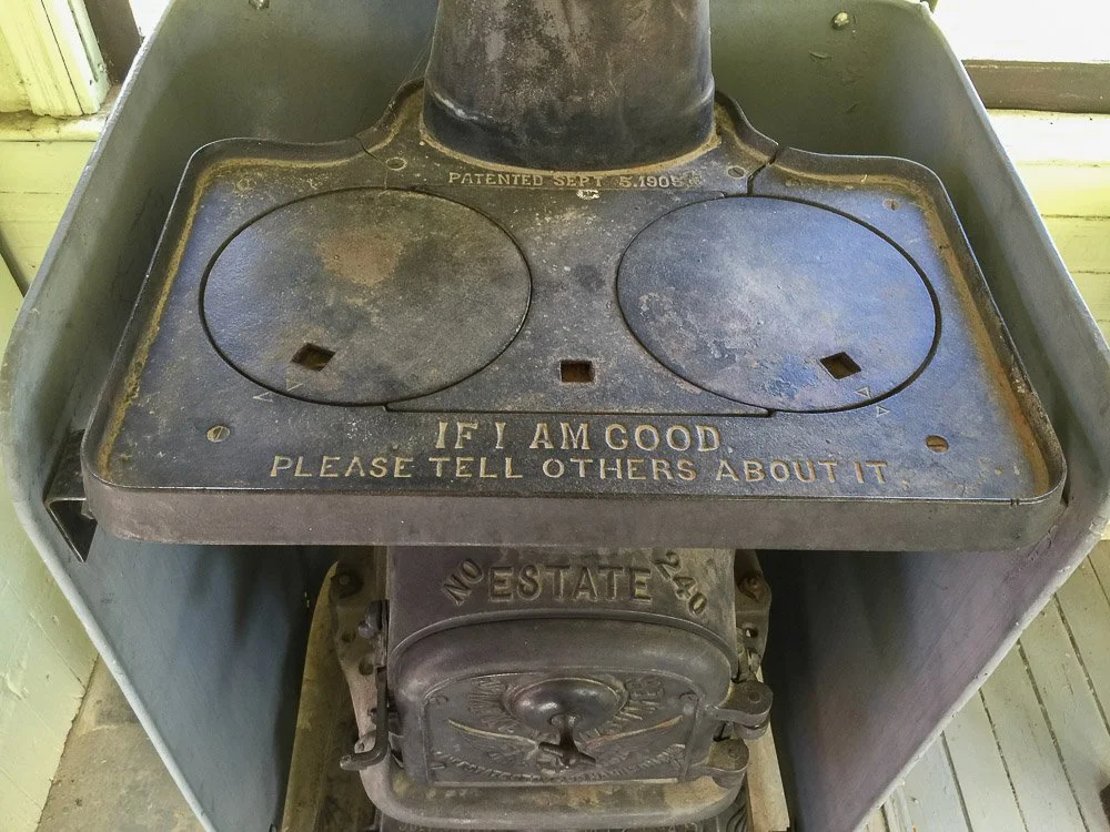
Stove in one of the train cars
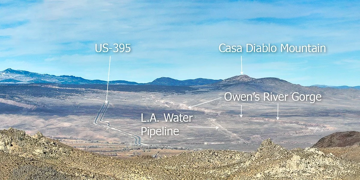
Okay, let's head back on the road towards US-395 north (first heading south/east on US-6 from the museum). When you exit Bishop, glance to your right: this is the Bishop Tuff. This area is recognized as the site of a geologically recent volcanic eruption (760,000 years ago) of gargantuan proportions. The volume of the Bishop Tuff is about 150 cubic miles and the US-395 leads 3000 feet uphill on this tuff.

Me running away from a volcanic eruption on the Bishop Tuff. Nah, I was just running towards my wife and daughter after flying my drone through the Owens River gorge
The material in the Bishop Tuff came from an eruption east of Mammoth Lakes: the Long Valley caldera. Here, millions of years ago, magma collected a few miles below the valley floor. The magma started to erupt through a bunch of volcanoes. Hot gases exploded from the top of the magma chamber (probably in one giant explosion), creating Long Valley and the Bishop Tuff. This was one of the biggest volcanic eruptions in geologic history from which ash and pumice was blown tens of miles into the air. Ash reached as far as Kansas. As the Bishop Tuff cooled, it contracts and creates five and six-sided columns which can be seen in the gorge that was created when Owens River slowly carved away into the Tuff.
A view of the Bishop Tuff from the Buttermilk Boulders west of Bishop
You can visit the gorge by taking a right turn at the Gorge Rd connector (a left turn here will take you to Paradise, a small community part of Bishop). Go north on Gorge Rd which stretches along the L.A. water pipe line. The gorge is a popular spot for climbers.

The Owens River Gorge from above, supplying colorful trees with water

A colorful fall cottonwood tree near Paradise. Cottonwood trees only turn yellow in the fall but I decided to color it with reds and oranges on photo paper
Now, let's head back to the US-395 and continue our journey north. We will pass Tom's Place and Crowley Lake. Crowley Lake is what feeds the Owens River.
Someone once told me that this "house" next to Crowley Lake was one of the first gateways to one of the first ski lifts in the Mammoth Lakes area. The “house” isn’t there anymore.
A cute little green church is located on your right at the corner of Benton Crossing Road and US-395. Well, that is, it used to be a Presbyterian church (1954) but is not used as a church anymore. At some point it was bought by the University of California. The current purpose is unclear to me.

The Little Green Church
Mammoth Yosemite Airport is located just north of the little green church and on the opposite side of the road is Convict Lake Road, which leads you to - you guessed it - Convict Lake. We have stayed several times at the resort here during winters. It is a beautiful lake surrounded by tall peaks and is popular for fishing (as are many lakes around Mammoth Lakes).
View of Convict Lake from the bridge at the head of Convict Creek. This photo was created by stitching multiple vertical shots: from left to right comprises a view angle of almost 180 degrees
Convict Lake and Convict Creek received their names after six escaped convicts hid here in 1871. They were part of a larger group of 29 convicts that escaped from the Nevada State Penitentiary in Carson City about 200 miles north of Convict Lake. 18 of the 29 escapees were captured or killed within 2 months of the break out and all but one were caught over time.
In December 2021 we got stuck at the resort after a blizzard dumped 5 to 6 feet of snow in the Sierras. We had to stay one night and day longer because both Convict Lake Rd and the US-395 were closed and not cleared of snow yet.
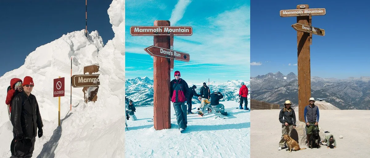
Next stop: Mammoth Lakes! Years ago we skied and snowboarded here on Mammoth Mountain, but also visited plenty of times in the summer. Outside the ski season you can mountain bike here, hike, enjoy the many lakes (fishing, stand-up paddle board, and maaaaybe swim but they're pretty cold), and revel in the local geology. Mammoth Mountain is a dormant (not extinct!) volcano, as are most mountains in the area.
On top of Mammoth Mountain with strikingly different levels of snow
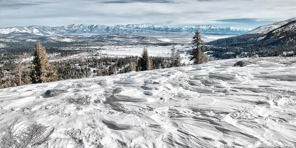
View of Mammoth Lakes and Long Valley (the caldera from which the Bishop Tuff originated) from Panorama Dome, when we went snow shoeing from the Tamarack Lodge. The white mountain range can be seen in the far distance
Four large earthquakes (magnitudes between 6.0 and 6.4) took place in 1980 in this area, with epicenters around Convict Lake. The nature of the quakes were pointing to magma movement on the outskirts of the Long Valley Caldera, only a couple of miles below the surface. No eruptions happened, but the people in the area were reminded they are living in a volcanically active area. The Mammoth Scenic Loop was built after these earthquakes as an alternative escape route should anything happen. Before this road was built, the only way in and out of Mammoth Lakes was over CA-203, which you will take to get from CA-395 to Mammoth. The Long Valley Caldera is closely monitored by the United States Geological Survey.
Other worthwhile sights in the area are The Devils Postpile National Monument (with solidified regularly shaped lava columns as we've seen at the Owens River Gorge), Rainbow Falls, the dead trees at Horseshoe Lake (these trees died because of carbon dioxide poisoning seeping out of Mammoth Mountain), and Hot Creek (north of Mammoth Yosemite Airport, with fumaroles and near-boiling water). Read here my latest blog on Hot Creek.
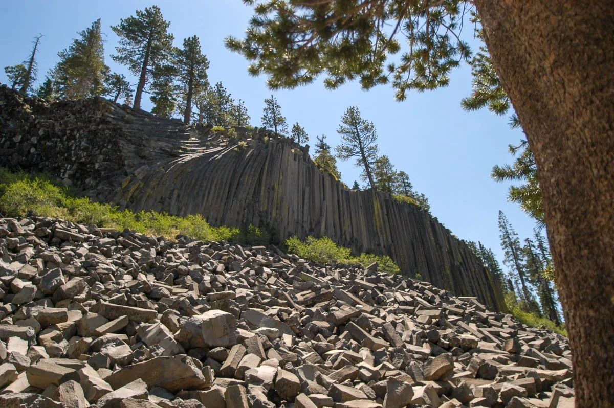
Devils Postpile National Monument, only accessible by bus
On top of the Devils Postpile
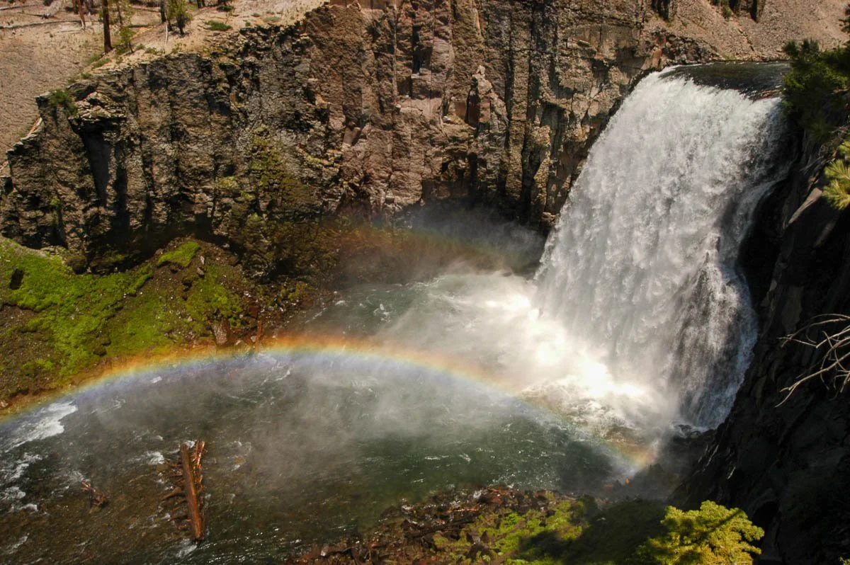
Rainbow Falls, nearby the Devils Postpile
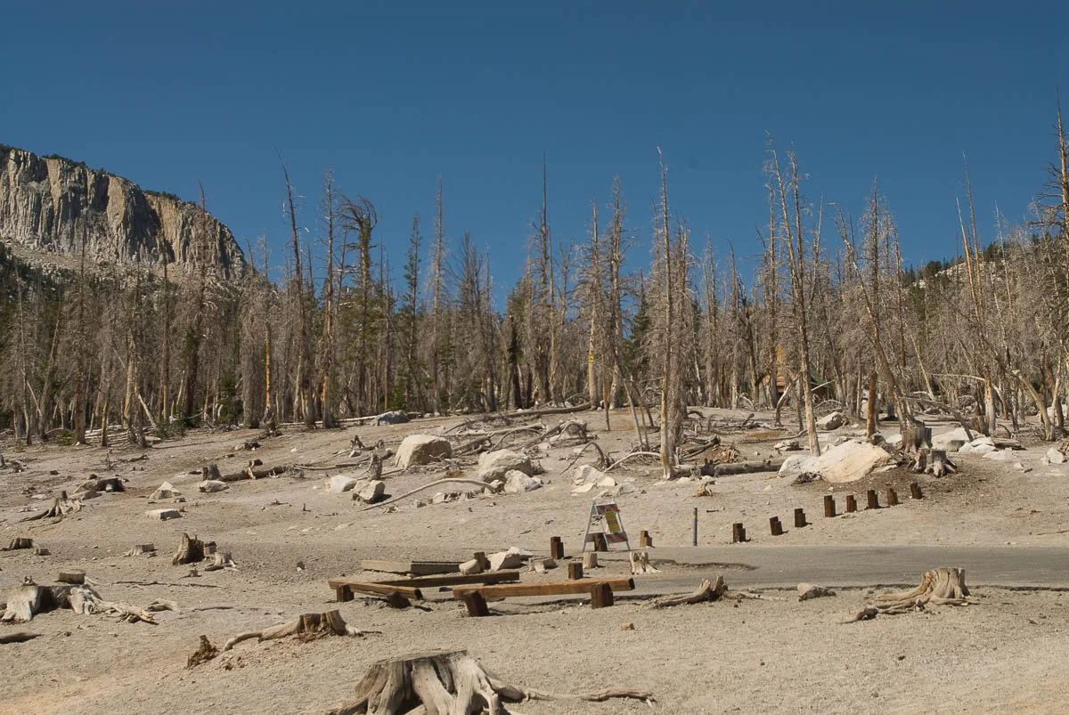
Pine trees killed by carbon dioxide poisoning seeping from the ground from Mammoth Mountain at Horseshoe Lake

Hot Creek. People used to bathe in the warm/hot waters (including myself), but the water got so hot at some point that people were getting scalded and the area was closed
It is without saying that there is plenty of stuff to see and do around Mammoth Lakes. Now, let's head back on the road and go north, where we will stop at Obsidian Dome.
This large blob of rhyolite magma oozed out of the earth only 600 years ago! I can only imagine walking here, with the ground suddenly rising and magma oozing out as it was a relatively non-violent eruption. The blocks here are a mix of rhyolite and obsidian (basically glass). Some roads have been cut into the hill which you can walk up easily.
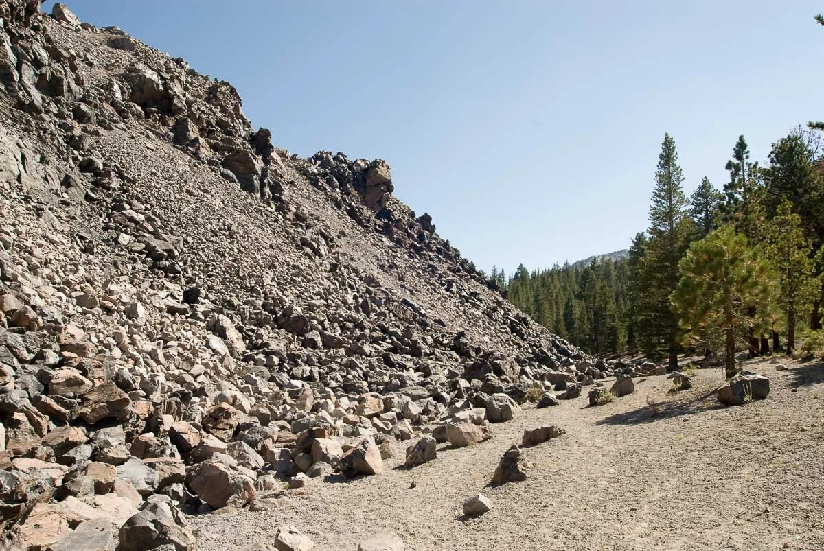
The north edge of obsidian dome with a very clear edge of the dome and the surrounding forest
My daughter when she was 16 months old, examining the obsidian
A close-up view of the pumice/obsidian marks on the boulders
The US-395 leads us through the beautiful pine forest to Mono Lake. Mono Lake is a large lake that is too salty for fish to live in, only brine shrimp. It is an important stop for many migratory birds. It was formed 760,000 years ago during the Long Valley eruption. It is geologically still very active as Paoha Island was formed from a volcanic eruption only 350 years ago.
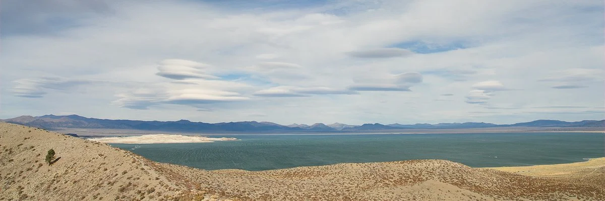
Lenticular clouds over Mono Lake as seen from Panum Crater on the south side of the lake. Paoha Island is the bright land mass towards the left
The surface of the lake started to decline rapidly after Los Angeles diverted streams in 1941. In 1990 it had lost about half of its volume and a deal was struck in 1994 with Los Angeles that Mono Lake's surface would have to reach 6392 feet above sea level which is 25 feet lower than it was in 1941. At its lowest it was at 6372 feet above sea level.
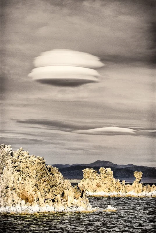
Lenticular clouds over tufas in Mono Lake at the South Tufa area
The lower levels have exposed so-called tufa's. They are limestone towers that are created under water. Water with lots of Calcium ions leaks through small spring openings at the bottom of the lake which react with bases in the lake water leading to calcite precipitation around the springs, building up over time into tufas, which can be observed when the water lake level dropped.
Mono Lake covered in fog in the winter. The Mono craters can be seen in the distance on the left. The US-395 is the road in the middle in the foreground. View from Mono Lake Vista Point
Tufa at the Boardwalk Tail in Mono Lake Park
The Bodie Railway & Lumber Company rail line (later called the Bodie and Benton Railroad) which operated between Bodie and Mono Mills, was built in 1881. Bodie itself was barren of trees, but there is an abundance of pine trees south of Mono Lake: the railroad would bring tons of wood to Bodie for the construction of stamp mills, mining supports, buildings, and for firewood. The railroad doesn't exist anymore but a marker is placed on CA-167 about 13 miles from US-395.
Mono Lake can be observed from a higher point from the Mono Lake Vista point on US-395 about 4 miles north of the CA-167/US-395 junction, but it's best to stop here traveling south on US-395 as the vista point is located on the southbound lane.
Next stop: Bodie!
Traveling further north on US-395, take a right at Bodie Road (CA-270). This road is a pass which is typically not cleared of snow: hence Caltrans closes this road with heavy snowfall. There is a second gate higher up the road, which still may be locked in winter times. If everything is open, you can reach Bodie by car. The last 2 miles or so is unpaved road.
On Bodie Road in the winter
Bodie in winter
The gold and silver mining town Bodie had its heydays in 1879. It was thought to be the 2nd largest town in California at the time (after San Francisco). Since 1962 it is a California State Historic Park, preserved in a state of "arrested decay". Many interiors have been preserved and one of my favorite buildings is the Boone and Wright General Store and Warehouse on the corner of Green and Main Street. It has tons of merchandise which you can see through the windows.

Pain relievers on the shelf in the Bodie General Store. Have a close look at the contents description on box on the left
In April of 2013 I paid for a permit to go inside seven buildings: the general store, the Methodist Church, the Dechambeau Hotel, Sam Leon's Bar, Lottie en Eli Johl's house, the Wheaton and Hollis hotel and the school. This was arranged through the Bodie Foundation. A monitor was with me and understandably I had to adhere to a lot of rules, as to not damage anything. I had to fold my tripod each time as I moved around, and couldn't touch cobwebs or dust on the old furniture.
Check out my Bodie gallery to see some of the photos I've taken there.

Looking out from the Wheaton and Hollis Hotel on Green Street towards the Boone and Wright General Store

A late 1800's Smith Premier typewriter on a desk in the Wheaton and Hollis hotel lobby

The organ in the Methodist Church (1882). This was only one out of two (the other being a Catholic church, not present anymore) churches in Bodie, California

Inside the elementary school. I took this photo from the view point of the teacher, making sure that the view outside is also visible

This photo of a lounge chair was taken inside Lottie and Eli Johl's house, the only residential building I entered. Through the window you can see the snow covered school building

Five bottles on the bar in the Dechambeau hotel on Main Street

An old Standard piano inside Sam Leon's Bar on Main Street
Rabbit trails in the snow in Bodie
Bodie was mostly abandoned in 1942 after the US became involved in World War II: a mandate was issued that said that no gold or silver could be mined anymore, only iron ore to make weapons. That's when the miners left Bodie, followed quickly by the rest of the town. On and off people still lived there or kept their houses as vacation houses. In 1962 the state bought the town and turned it into the Historic Park it is now.
As I've mentioned in Part 1, the US-395 leads all the way to Canada. On this highway, I have not been further north than Lake Tahoe, California. It's definitely worth also visiting areas north of Bodie, such as Bridgeport and Lake Tahoe, but I'd like to end it here at Bodie, California. Hope you enjoyed reading and if you haven't yet, take a wonderful road trip on US-395!
Literature
Geology Underfoot in Southern California, Sharp and Glazner, 1993
Geology Underfoot in Death Valley and Owens Valley, Sharp and Glazner, 1997
Big Bad Bodie, Watson and Brodie, 2002

US-395: From Southern California to Bodie | Part 1: from San Diego to the Bristlecone Pine Forest
US-395: From Southern California to Bodie
Part 1: from San Diego to the Bristlecone Pine Forest.
Bodie is one of the best preserved ghost towns in the US. Located in the Eastern Sierra Nevada just north of Mono Lake it was a thriving gold and silver mining town in the late 1800's. You can read here about my first two visits to Bodie.
Bodie covered in snow
During Thanksgiving 2022, my wife, daughter, brother-in-law and I visited again. Here, I'd like to share a compilation of experiences from multiple trips of traveling to Mono County from San Diego over the US-395. As the CA-1 along the Pacific Ocean is one of the most popular scenic drives in California, the US-395 for me certainly rates up there too.
Nowadays, the US-395 stretches between Interstate 15 in Hesperia, California and the Canadian border in Washington state. In the early-mid 1900's it also stretched between Hesperia and San Diego. You can still find Historic US-395 signs in several locations (for example on Park Blvd in San Diego). In San Diego it connected to the Pacific Highway. Later, SR 163, I-15, and I-215 replaced it.
Typically, when you leave from San Diego County, you'll end up on Interstate 15 North pretty quickly. In Murrieta, California, you can choose to continue on the I-15 or take the I-215. The latter is a little shorter. Which one is faster depends on the time of day, but in the morning we usually take the I-215.
The I-215 joins the I-15 again just north of San Bernardino at Devore. This is an interesting area. Here, the I-15 crosses the San Andreas fault where the North American and Pacific continental plates grind past each other at Cajon Pass. Interactions between the San Andreas fault, Cajon Creek and Lone Pine Creek led to a more gradual slope facilitating trains' climbs on the railroads and cars and trucks on the I-15. Without going into too much detail, the softer and already ground rocks of the San Andreas fault were easily carved by the creeks, creating the Cajon Amphitheater. The I-15 makes a big curve through the Cajon Amphitheater, with the north and south bound lanes far apart, creating a giant median. You'll find trucks in the (extreme-)slow lane, creeping up the hill.
About 4 miles after passing Cajon Summit at around 4200 feet elevation you'll reach the ramp to the US-395. Depending on what time we get here we like to stop at the Outpost Café for breakfast or lunch. Last time though we got here at 5:30am and kept on driving. The road leads you through small desert towns and switches back and forth between single and double lanes.
A large airport is located east of Adelanto: the Southern California Logistics Airport. It is mostly known as a commercial airliner boneyard, and maintenance and storage area for big planes for airlines from around the world. The dry desert air is gentle on the plane metals.
From here on out the US-395 leads in a virtually straight line to Kramer's Junction, where it intersects with California State Route 58. A large solar plant is located north west of this intersection: Kramer Solar Plant. This solar plant makes a brief appearance in the 1997 movie "Gattaca" with Uma Therman and Ethan Hawke.
Continuing north, US-395 leads as a single lane in long straight sections that are gently sloped uphill towards Red Mountain, which is both the name of a mountain and a tiny town, which is surrounded by abandoned mines. Right after you'll pass through Johannesburg with views of mountain ranges on the other side of the Red Mountain crest. Here, you can make a stop at Randsburg, a "living ghost town".
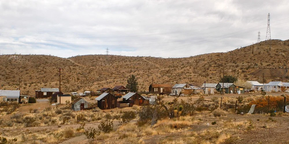
Randsburg, the living ghost town
This is a gold mining town that grew from mining camps in the late 1800's. Gold was re-mined here in the 1980's and 1990's.
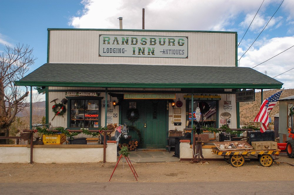
The Randsburg Inn
We stopped to eat some food at a place that was a restaurant, bar and grocery store all in one.
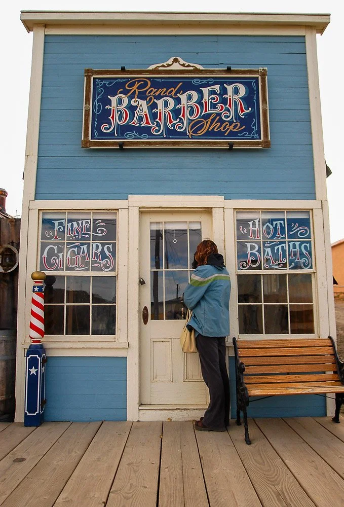
The barber shop in Randsburg
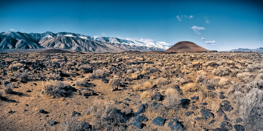
A few miles after Randsburg you can take the business route of US-395 towards Ridgecrest, but we will continue on the US-395. This is where you get your first sight of the mighty Sierra Nevada to the west and where we enter Owens Valley. In winters with lots of snow the peaks of these mountains will be snowcapped. Owens Valley is part of the Great Basin and is a down-dropped block of land between two faults. It is still dropping down while the Sierra Nevada is still growing. It is flanked by the Sierra Nevada to the west and by the Inyo and White Mountain range on the east.
Just north of Inyokern, after about 10 miles after the US-395-CA-14 junction you will reach a beautiful lava field and a tall volcanic wall on your right. This is part of the Coso Volcanic Field. Lots of volcanic vents are located here. The last eruptions occurred about 10,000 years ago. The area is still considered volcanically active (only dormant) with one of the largest geothermal power plants in the area. After the M7.1 earthquake on July 5th, 2019 near Ridgecrest the area was closely monitored. Hundreds of small aftershocks per day were recorded but no signs of a volcanic eruption.
Red Hill Cinder Cone and nearby Fossil Falls are located after about a 4 minute drive after passing Little Lake. Red Hill at 630 feet is an almost perfectly symmetrical volcanic vent that erupted last about 10,000 years ago. The porous lava from these cinder cones are popular ingredients for lightweight concrete products such as cinder blocks. The area around Red Hill is still mined for these materials but a compromise was struck that mining could only be performed while keeping the profile of the hill intact.
Red Hill Cinder Cone on the right and the Eastern Sierra on the left
Red Hill Cinder Cone on the right with its latest lava field in the foreground. In the back we have snowcapped peaks of the Eastern Sierra Nevada mountain range
Take a right turn on Cinder Rd - just before Red Hill - and follow the road towards the Fossil Falls parking lot. From here it's a short hike to Fossil Falls. Before water was diverted to Los Angeles in 1913, during glacial times about 10,000 years ago, Glacial Owens River plunged here over Fossil Falls. There are two drops here about 200 feet apart: the higher one is 70 to 80 feet tall and the lower one about 30 feet. Smoothly polished surfaces here are a sign that the water was sediment-laden. There are many potholes here, created by vortices in the muddy water.
Here I'm standing in a pothole at Fossil Falls (yes, I know I look much younger here because it was 2005)
Our daughter Kate and dog Puffy hanging out on a lava field next to Fossil Falls in 2017
On a nice personal note: it was here at Fossil Falls where my wife and I declared our love for each other in 2005 when we were dating:

Shadows of my wife and I on the walls of Fossil Falls
Okay, enough kissing so let's head back out on US-395 north. After about 30 miles we will turn right towards Owens Lake to visit the Cottonwood Charcoal Kilns. This is an unnamed unpaved road but I believe a sign with "Historical Landmark #537" is placed here. These giant beehive shaped kilns were used to make charcoal from trees in Cottonwood Canyon to feed the gold and silver mine smelters at the Cerro Gordo mines.
Remains of the Cottonwood Charcoal Kilns
Before 1924, Owens Lake used to be a large lake at 15 miles long, 10 miles wide and 30 feet deep, filled with the water from glaciers from the Eastern Sierra. The lake started shrinking in 1913 when most streams were diverted into the Los Angeles Aqueduct. Now it's a large (mostly) dry salt flat. After rain storms it will partially fill and will show some bright red and pink colors due to salt-loving algae.

Ruins of a plate glass factory at the north end of Owens Lake, which was abandoned in 1968
After about 14 miles leaving the kilns we are entering Lone Pine, gateway to Mt Whitney, the tallest (14,505 feet) mountain in the contiguous U.S. There are several small towns dotted along the US-395 in Owens Valley. The normal speed limit on the freeway is 65 mph. For each town, the speed limit is reduced to 30 or 25 mph. Especially in the smaller towns, the California Highway Patrol is on the lookout for speeding and I've witnessed them many times pulling people over.
The very rustic Motel sign
Not only is Lone Pine known for being a starting point to climb Mt. Whitney, many movies (the town has a Western film museum) have been shot here in the nearby Alabama Hills. The Alabama hills are about 9 miles long, a couple wide and about 1500 feet tall. They are the tip of an escarpment (a long steep slope) along the Owens Valley fault zone. Owens Valley is a valley that is really around 10,000 feet deep, but filled in with unconsolidated sedimentary material, making the Alabama Hills almost just as tall as the Sierras!
A big earthquake struck the region here on March 26th, 1872, with an estimated magnitude of 8 or larger. Nearly every building in Lone Pine made of hard materials (such as brick or stone) collapsed and killed 23 people. The ground along the Lone Pine fault moved 10 to 15 feet laterally.
About 11 miles north of Lone Pine we are reaching Manzanar National Historic Site. The Manzanar War Relocation Center was one of 10 camps where the US government incarcerated Japanese immigrants and Japanese American citizens from 1942 till 1945, after the US became involved in World War II.
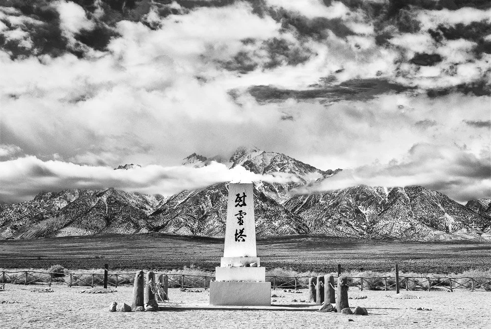
The Soul Consoling Tower
Master stonemason Ryozo Kado and Buddhist minister Shinjo Nagatomi designed the monument at the cemetery pictured above as a tribute to Manzanar’s dead. Kado, Block 9 residents and a Buddhists’ group, built the monument in 1943. The inscription reads "Soul Consoling Tower". Manzanar is a reminder that we must never allow to occur again.
Going back on the road, we are passing through Independence, which is a tiny town with the Inyo County Courthouse, built in 1921/1922. As far as I know it's not in use anymore.
Twenty-six miles north of Independence we are driving through Big Pine, from where it's a 24 mile drive on CA-168 to the Ancient Bristlecone Pine Forest. This area contains some of the oldest trees in the world, exceeding 4000 years. They are beautiful gnarly and twisted shaped pines. While parts of these trees die, other parts are alive. (Also check out our latest winter visit here)
The gnarly bark of a bristlecone pine tree
Bristlecone Pines
When we visited the area we stayed at the Bristlecone Motel in Big Pine the night before. We got up super early (around 4am) so we could catch the pines and the area at sunrise.
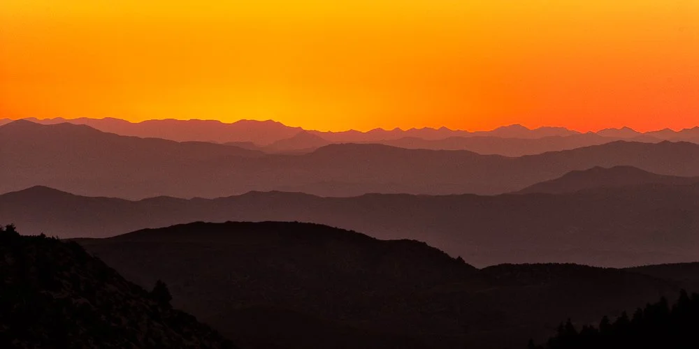
View east from Bristlecone Pine Forest at sunrise
And the silhouette of a Bristlecone Pine at sunrise
Our next stop is Bishop, California in part 2
Literature
Geology Underfoot in Southern California, Sharp and Glazner, 1993
Geology Underfoot in Death Valley and Owens Valley, Sharp and Glazner, 1997
Back to Bruges
Back to Bruges
In 1998 I was excited to attend my first conference on cardiac pathophysiology in Ghent, Belgium, which is a beautiful medieval town in Flanders. The conference organizers had also planned a bus day trip to Bruges (Brugge) about 50 km away, also in Flanders, Belgium. Bruges, its name first appearing in the 9th century, is one of the best preserved and gorgeous medieval towns of Europe. The town served as the backdrop in the brilliant movie "In Bruges" (2008), starring Colin Farrell.
I loved the town and always wanted to go back some time. The summer of 2022 provided a good opportunity as we (my wife Marie, my daughter Kate and I) visited the south of the Netherlands for three weeks. We stayed in Bruges for two days and nights, in a hotel right behind the Belfry (Belfort).
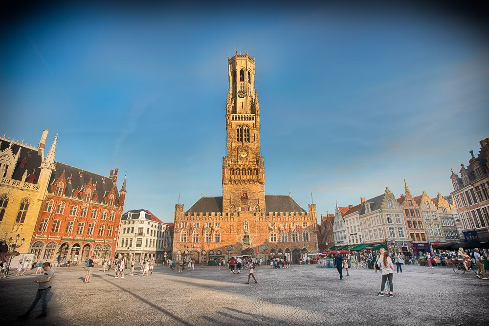
The Belfry (Belfort) with its 83 m (272 ft) high bell tower
In 1089, Bruges became the capital of the County of Flanders and in 1128 it received its city charter. It had its Golden Age from the 12th to the 15th century because of its close proximity to the North Sea, being located on the crossroads of multiple trade routes and the influence of the dukes of Burgundy, which brought more commerce and culture to the city. The city survived the two world wars relatively unscathed, and in 2000 the historic city center became a World Heritage Site of UNESCO.
The day we arrived we enjoyed a Belgian beer at the Duvelorium. From here we had a great view of the Marketplace and its surrounding buildings. We made some loose plans for the next two days. One of them was to climb the 366 steps of the Belfry tower, but early in the morning the next day as it was going to be a hot one.
It was time to soak in some Golden Age vibes. We headed toward a canal where you can join a boat tour. When we saw how busy it was and how cramped the little boats were, we passed on this opportunity. It turns out though, that this location has one of the most famous views of the Belfry, with the water in the foreground.
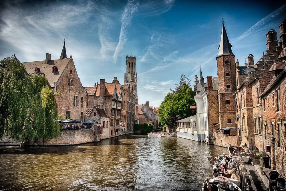
The Belfry tower behind one of the canals in Brugge
From here we walked through some narrow streets to Bruges City Hall from 1421. With the sun setting some beautiful warm light hit the late Gothic structure:
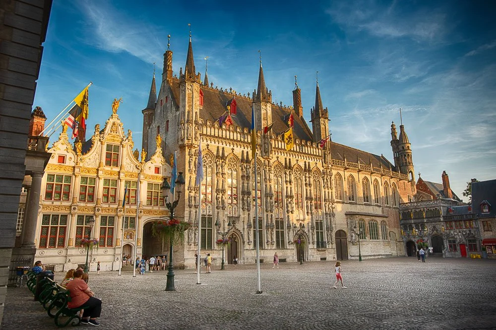
Bruges' City Hall (Stadhuis) at the Burg Square (right massive building) and the Burgse Vrije (left) which was a courthouse (1700s)
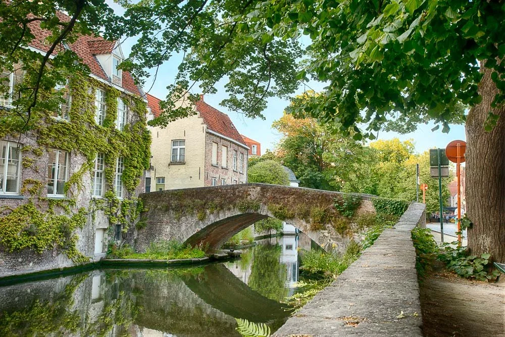
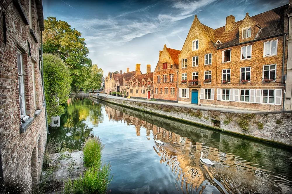
After walking around a bit and eating some Belgian Waffles, Marie and Kate wanted to relax at the hotel and I was let loose in the city with my camera. At this point in the evening it wasn't that busy with people anymore. I headed back to the Groenerij Canal behind the City Hall. Here I walked along the canal for a bit and captured some shots of stone arch bridges and the famous swans of Bruges.

The stone arch Peerdenbridge (Horse Bridge) over the Groenerij Canal in Bruges, Belgium
Two white swans swimming on the Groenerij canal in beautiful Bruges, Belgium among medieval architecture
The story goes that in the 15th century, the inhabitants of Bruges (Brugge) in Belgium captured the emperor Maximilian of Austria, because he imposed taxes and forbid festivities in the town. After he escaped he took revenge by forcing Bruges to care for swans for all of eternity. They are still there today.
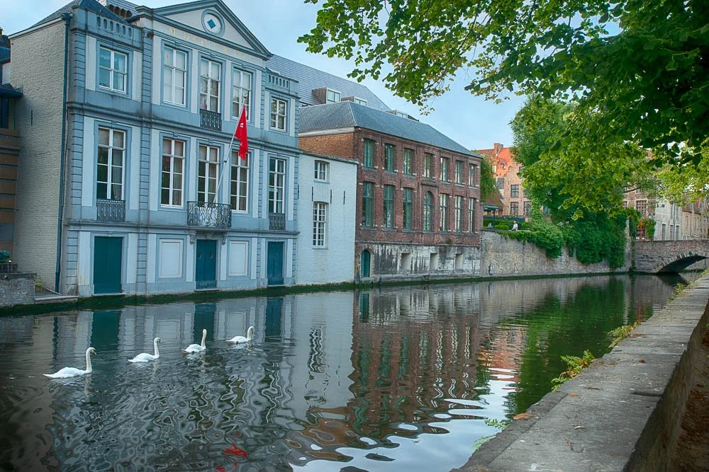
Four white swans swimming on the Groenerij canal
The next day we got up all excited to climb the Belfry Tower. We paid for the tickets and started climbing. Fortunately there are several levels where you can stop, take a rest and look at some exhibitions.
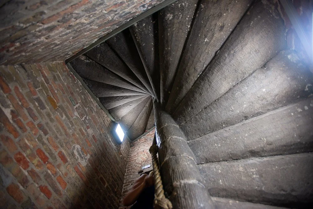
The narrow spiral staircase in the Belfry tower: you can get some support by holding on to the rope down the middle
The bells in the tower regulated the lives of the people of the city. The bells announced the time, but also fire alarms and work hours. They would also announce a variety of social, political, and religious events: at a small exhibition on one of the floors you can listen to these different bell sounds.
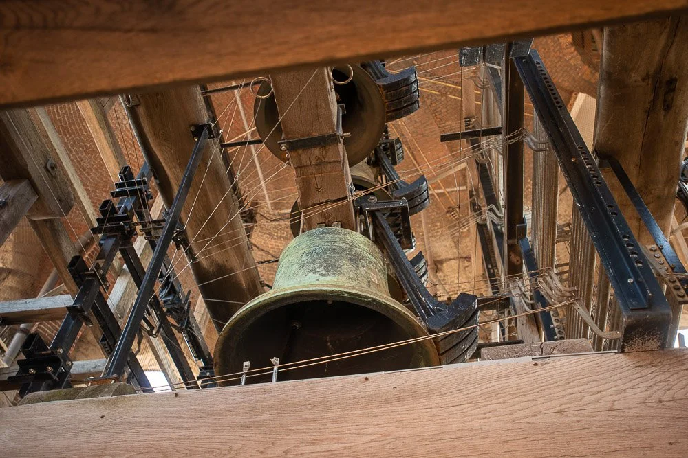
Bells and mechanism in the Belfry tower
In the 16th century the tower received a carillon, allowing the bells to be played by with a keyboard. Now it also has an automatic mechanism by which tunes are played on the bells. The mechanism is a large metal cylinder (playing drum) connected to the bells. Metal pegs are screwed onto the outside of the drum, which catch onto levers and to the hammers that rest from the outside of the bells. When the drum rotates, tunes are played. We stayed till this happened, and it was very loud!
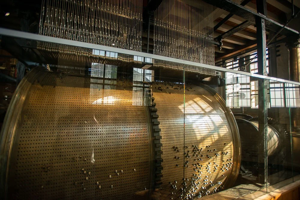
Playing drum cylinder in the Belfry tower
Today there are 47 bells, together weighing about 27.5 tonnes. The bells range in weight from two pounds to 11,000 pounds.

Looking down at the Marketplace from the top accessible floor in the Belfry tower
Two days obviously is not enough to spend in a gorgeous town like this. For example we had not have time to visit the old gates at the perimeter of the city center. We DID visit the chocolate museum (with all-you-can-eat-samplings!). I definitely recommend a visit to this town where you can almost literally point your camera randomly anywhere with good results!
8. Sharks, Dolphins, and a Barracuda | Hawaii 2021
8. Sharks, Dolphins, and a Barracuda | Hawaii 2021
Day 8
We all slept in. Marie and I till 6:30am and Kate till 7am. Marie got some coffees from Starbucks (no line she said) and we drank them on the balcony. So nice to hear the ocean and the many birds here.
Closer to 9 we grabbed our stuff and headed to the beach where another snorkeling tour awaited us. We had to board the catamaran with our flip flops taken off as we had to climb stairs that were lowered on the beach. That went eventless. As we were the last to board all the benches were taken at the front. Everyone was told to stay in the front until the captain was able to get the boat off the sand. When that happened I went to the back and conquered a bench for us with two little tables.
We were going to visit two spots: first Mala Beach, followed by Honolua Bay. They said that there are always turtles at Mala Beach. Part of a collapsed pier has created an artificial reef and turtles go there to have themselves cleaned by surgeon fish. While the captain was giving a Snorkel 101 lecture at the bow I looked back and saw five turtles at the surface!
Mala Beach
It is this beach that inspired me to create "Mala Pier Reef", a composite of 27 photos that I took here.
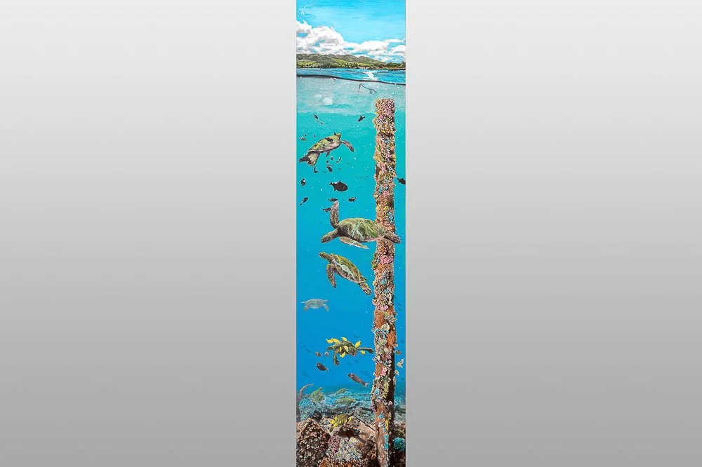
Mala Pier Reef
Kate stayed behind to read so Marie and I entered the water. Immediately there were turtles everywhere. Either floating at the surface, suspending mid water, or hanging out at the bottom. Four or five turtles were sitting on a collapsed part of the pier with fishes eating stuff off their shells. I couldn’t believe it: I took lots of photos and videos. Kate joined us a little later.

Green Sea Turtles chillin’ on the bottom
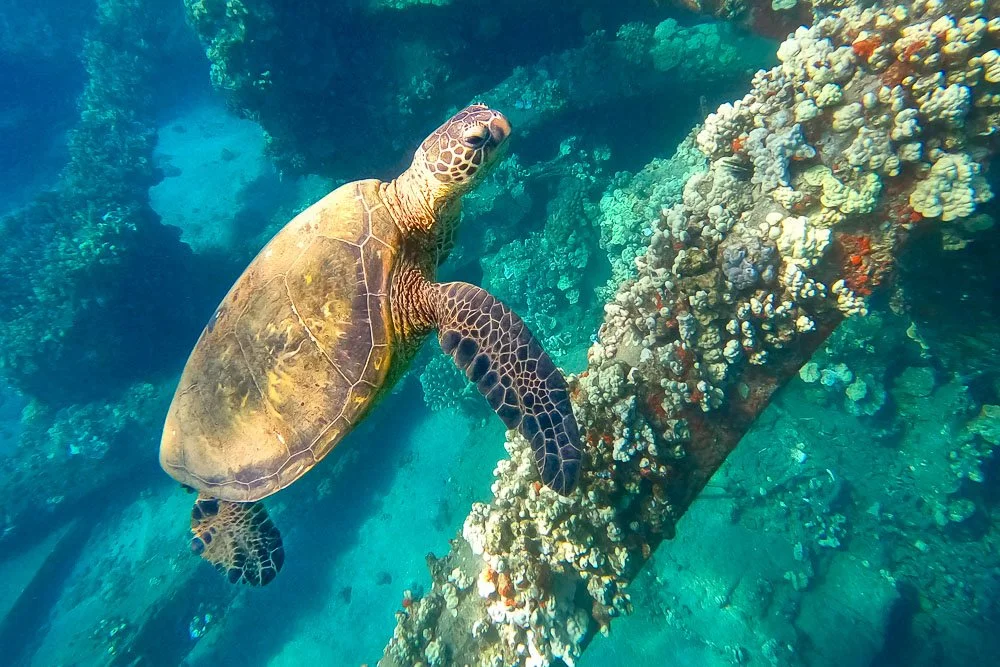
A Honu at a coral covered pier pilar
Black Durgon fish cleaning a turtle
When we were about to head back to the boat, a snorkeling lady told me that there was a reef shark sitting on the bottom. I saw it too. I tried to get some shots but its front was under a concrete slab. I started swimming back to the boat when I saw two moving reef sharks! One seemed to follow the other. They swam from one concrete slab to the next. At some point I was following only one, that’s when I heard the captain calling back everyone.
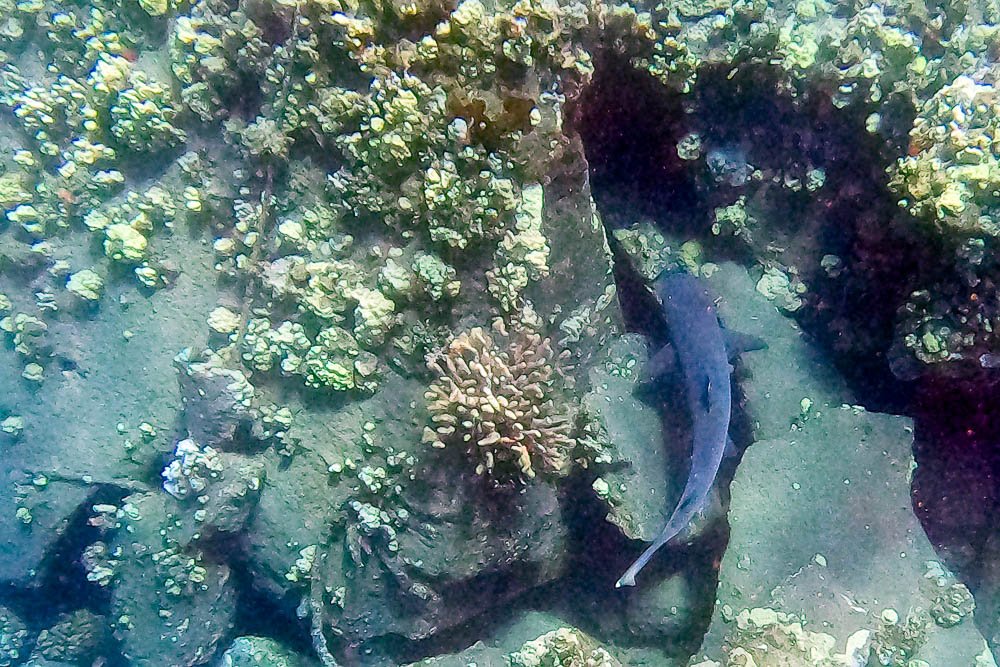
A reef shark at the Mala Pier
Now we were heading for Honolua Bay, which was going to take about an hour. We were fed lunch and drinks and it was good. One of the boat crew members spotted spinner dolphins and we followed them for a while. I saw a few jumping out of the water and spinning along their long axes (hence their names), but wasn’t able to capture them on camera while doing that. I did get some footage of them swimming along with us.
When we arrived at the bay there were only two other boats there. From the boat you could already clearly see the corals underwater. All three of us got in the water. The corals were beautiful; all kinds of colors and shapes. Lots of different fishes too. We saw a large school of fish hanging out near the bottom. Even when I got closer they hardly moved. Marie said they were the laziest fish she’s ever seen.
Next we saw a school of Manini Convict Tangs and Humuhumu-Eleele Black Durgon Triggerfish eating off the bottom. Other fishes we saw were yellow tangs, Uhu Bullethead Parrotfish, Pennant Butterflyfish, Humuhumu-Nukunuku-Apuaa reef triggerfish, Hinalea-Iiwi bird wrasse, Kala Unicornfish, and many more.

Manini Convict Tangs
I drifted away from Marie and got closer to the rocks. I turned around and saw something big and was startled. It was an over three feet long fish. I had no idea what it was and went a little closer to get some shots of it and a video. It started to swim away and I followed it for a while. Later I found out that it was a Kaku Barracuda! (Most other fish names I also looked up later BTW, in case you may think I’m a Hawaii fish expert).
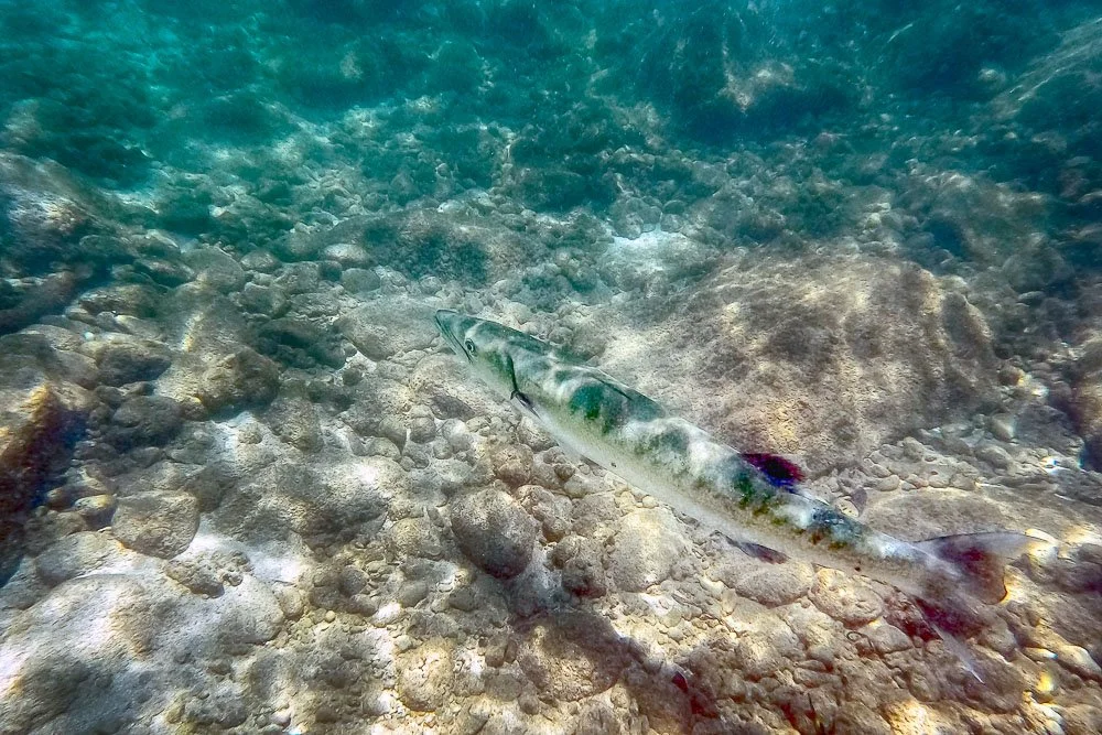
The Kaku Barracuda
I searched for Marie and told her about the big fish. She then told me that below us a crab is eating a sea urchin (a Punohu Slate Pencil Urchin that is and the crab was a 7-11 crab). A fish was also trying to eat the urchin where the crab had damaged it.
A 7-11 crab munching on a pencil urchin
The captain was calling us back now. Because it was windy the boat crew raised the sail and for a while we sailed with the engine off, heading towards Molokai and then turning towards our hotel beach. It was a great snorkeling trip, perhaps one of the best so far? Dolphins, turtles, sharks and a barracuda. Kate still likes to make fun of me claiming that I researched if I was in mortal danger during my barracuda encounter.
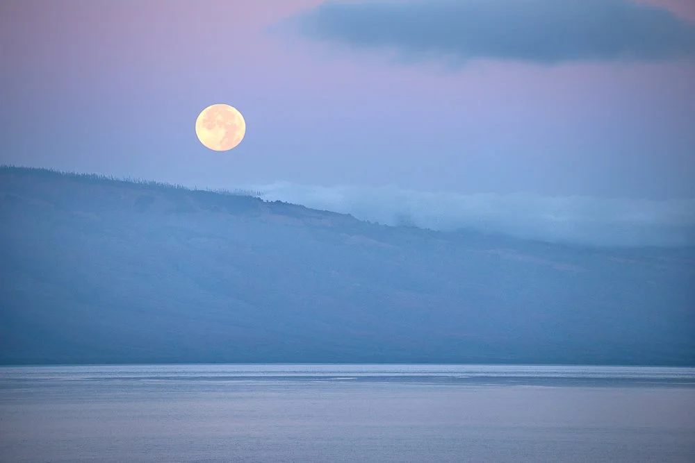
7. Full Moon over Lanai Island | Hawaii 2021
7. Full Moon over Lanai Island | Hawaii 2021
Day 7
A super moon total lunar eclipse was going to take place this morning at 1:11 Hawaii Standard Time. Initially I thought I was going to take a picture of it, but then decided not to: first of all, it was going to be straight above me. Now, if it would be just above the horizon, or at least close enough to it, that would make a much better photograph. Just the moon, red, eeh, not so much. And I’ve seen lunar eclipses before. Oh, and did I mention it was going to be at 1:11am…?
Okay, now that I laid down my case for not photographing it, I got up at around 5:30am, I looked out the window... and behold! A full moon, right above the island of Lanai, looking as if it’s rolling off the island, with a beautiful blue-purple ocean in front of it, and a subtle pink sky above. Now, THAT is something I needed to photograph: I took a few photos horizontally and vertically with varying focal distances (I had put my Sigma 100-400mm on my camera). Plus, several vertical shots at a long focal distance, while moving the camera from left to right, keeping some overlap between the photos. In this way you can create wide high resolution panoramas.

Close up of the full moon setting over Lanai

The full image with the moon rolling off Lanai
We had to get up early anyway, because today was our snorkeling trip to Molokini Crater. We got in our car and drove to the Maalaea Harbor. The trip was organized by the Pacific Whale Foundation. After checking in, all 74 of us walked to the large catamaran and hopped aboard. Today the Hawaii governor announced that wearing masks outside (i.e. on top of the boat deck) was not necessary anymore. Seats were assigned and breakfast and lunch were brought to us. Not bad. Just the three of us were placed on the top deck in front of the helm. Also excellent. In the distance the little island could already be seen.
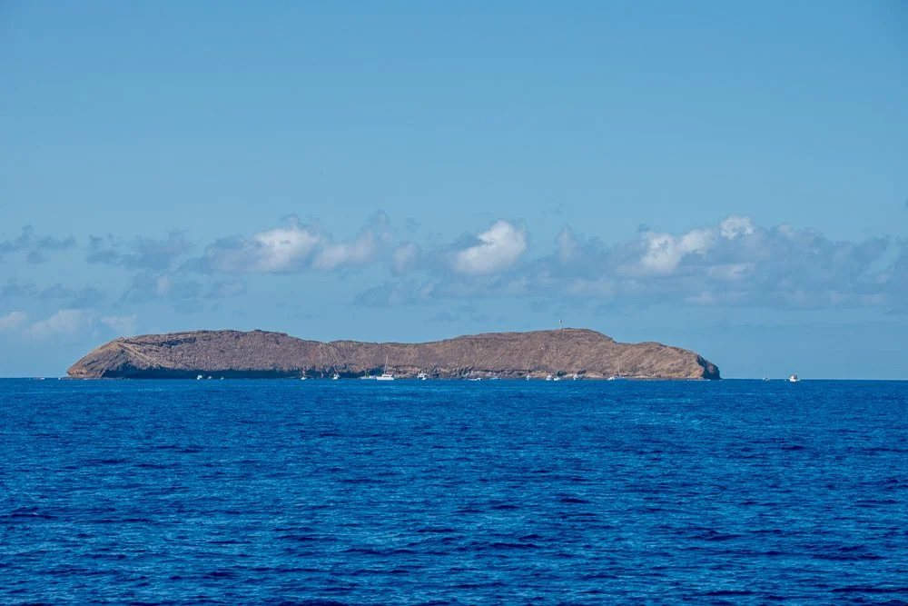
Molokini crater in the distance
While we were sailing the first mate told us a bit about Hawaii tectonics and that Molokini is not a crater but an old vent of Haleakalā volcano, which is the east Maui volcano that is dormant (it erupted last time between 1480 and 1600). Molokini is both a marine and sea bird protected sanctuary.
It perhaps took about 45 minutes to get there. There were already LOTS of other people in the water from other tours. We were asked if we wanted a wet suit and many people on our boat wanted one. Marie asked if the water is particularly cold in this area. The boat lady said that the water is about 74 degrees Fahrenheit. Marie looked at me, laughed, and said that we would be thrilled in San Diego to have 74 degree ocean water, so we declined the wet suits. We took the slide with our snorkel gear on to get in the water. Other options were ladders on the back of the boat. However, following my strategy of just running into the water without caring (from day 4), we thought taking the slide forces you without hesitation, cold or not. It worked. In fact, we didn’t think the water was cold. Visibility was indeed more than 100 feet, as advertised.
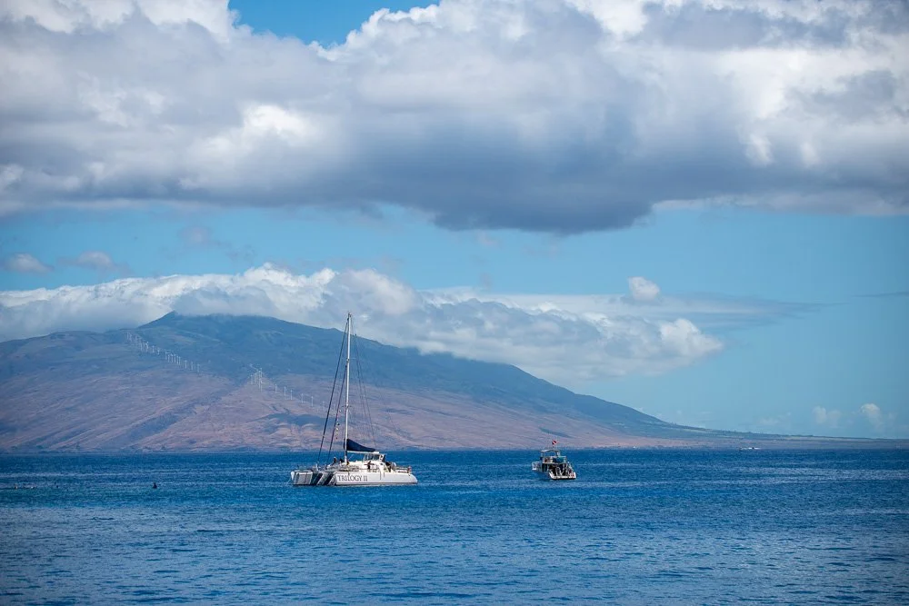
Boats off the coast of Maui
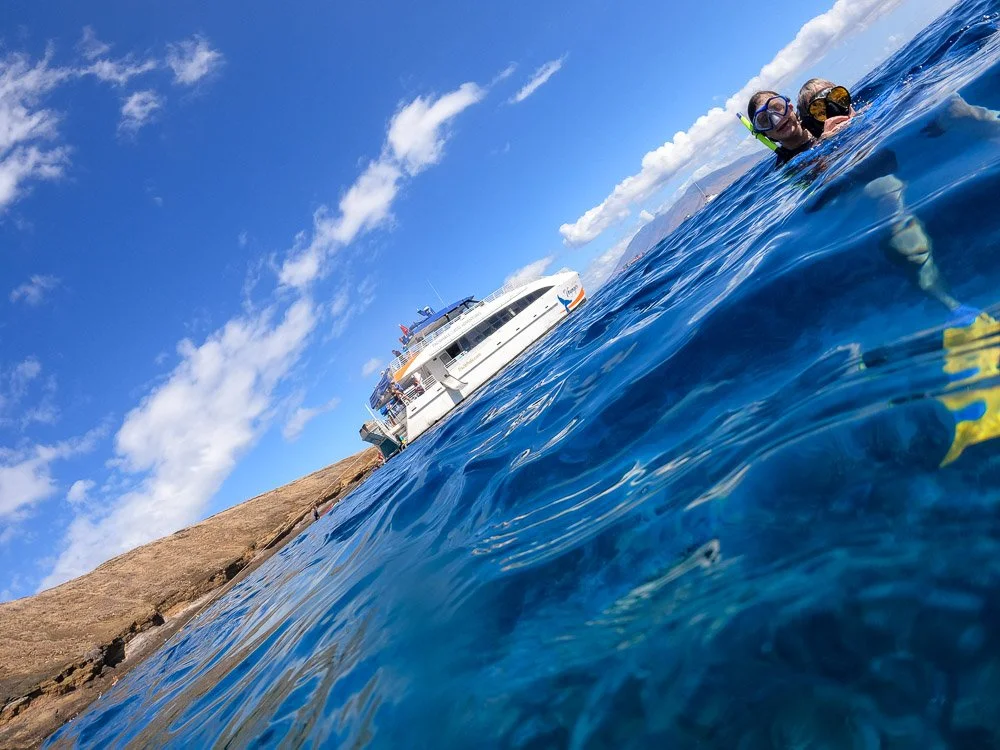
Kate and Marie at Molokini Crater
The newest fish we spotted was a female moa spotted boxfish (I think). I also tried to get a good look of the Bulwer’s petrel birds that nest on the little island. Earlier the boat lady had said that those are the birds flying around here that look like pterodactyls. They indeed do. After swimming around a bit I headed back a littler earlier than most people so I could try to get some photos of those birds with my Nikon and 100-400mm lens. Unfortunately, they were still too far to get some good photographs of them.
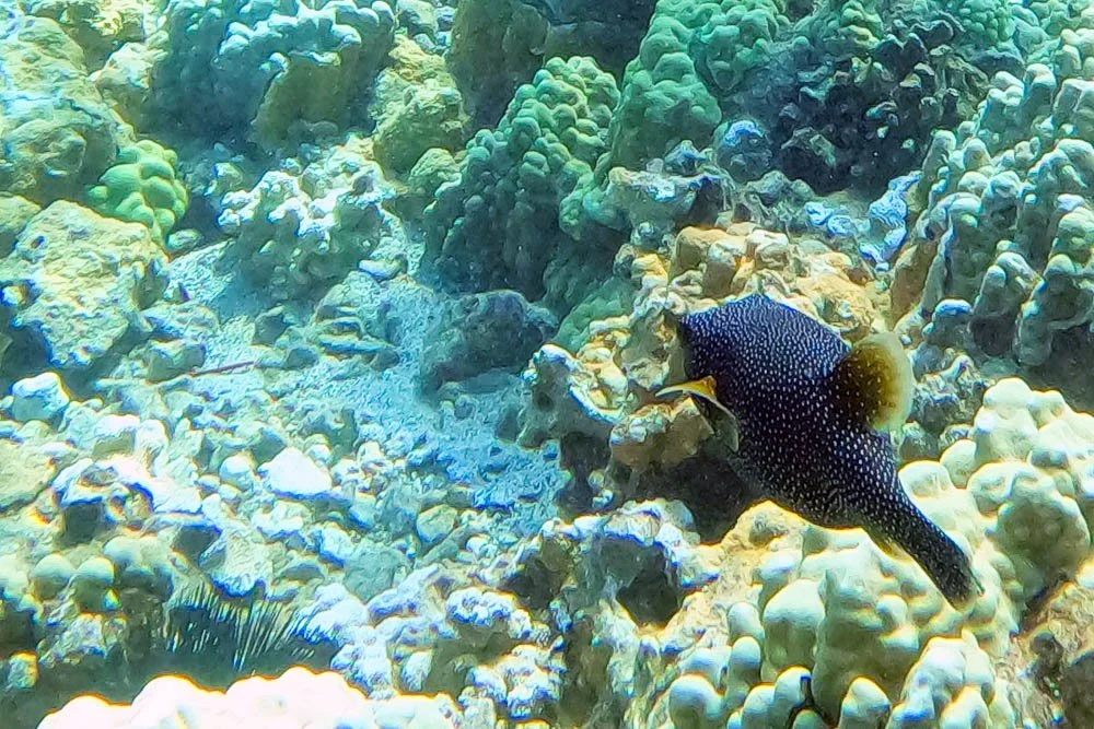
A Moa Spotted Boxfish
Overall, we were a little bit disappointed (hey, no whale sharks I told my daughter about on day 2), but our snorkel tour from 2017 at the Big Island may have spoiled us as that trip hasn’t beaten anything yet after that. Tomorrow we were going on another snorkel trip with Telanani 5 and Kate asked why we were going again. The nice thing is that we didn’t have to drive anywhere as boarding was right at the beach in front of our hotel. And I’m glad we went! It was going to be one of the best!
A Bulwer’s Petrel Bird
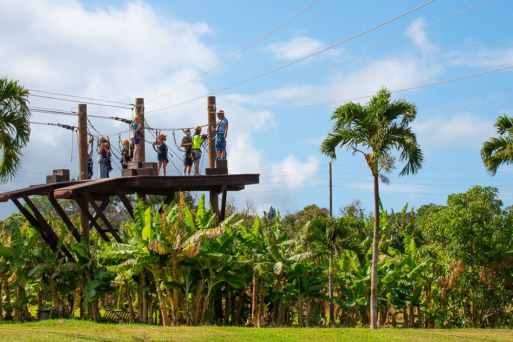
6. From the Ocean to the Skies | Hawaii 2021
6. From the Ocean to the Skies | Hawaii 2021
Day 6
At 2:00 o’clock we had to check in at the Maui Zip Line, so we had some time to do something else in the morning. First we were thinking of going to the beach just in front of our hotel at Kāʻanapali Beach but instead decided to pack all our clothes and swimming gear and drove to North Kāʻanapali instead.
I turned north on Highway 30 and took a random left turn at some point. Turned out it was Kahekili Beach Park. Perfect. We plopped our stuff on the grass next to the sand. When we got to the water you could clearly see rocks just a little off shore. I tried swimming and was touching the rocks with my knees. So we all put on our snorkel gear and swam over them. It turned out to be one of the best snorkeling spots so far!

A colorful fish north of Kāʻanapali Beach

… and a black one
The water was super clear and the whole floor was covered with all kinds of coral. Among plenty of fish we spotted a very large nunu peke.
After a little while Kate wanted to play in the waves without snorkel gear and Marie went with her more south where there was more sand. I stayed behind. I dove to the bottom to get some videos of fishes swimming just above the coral and when I came up a saw a turtle. When it dove to the bottom I followed it for a a bit.
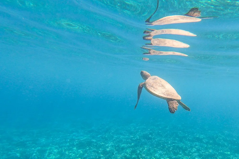
And a turtle also stopped by
There were a lot of scuba divers around. I swam past them to find Marie and Kate. I saw them and tried to sneak up on them from the water. However, Kate spotted me and attacked me.
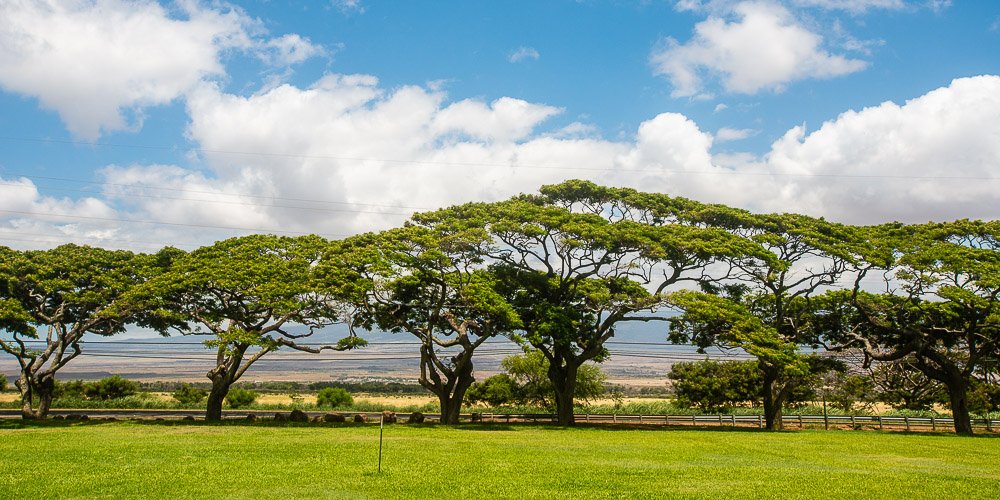
Beautiful trees lining the street on Maui
The zip lining company was easy to find on the farm. We were a little early so we walked around. I took some pictures of a chicken with her chick and ducks. They came very close.
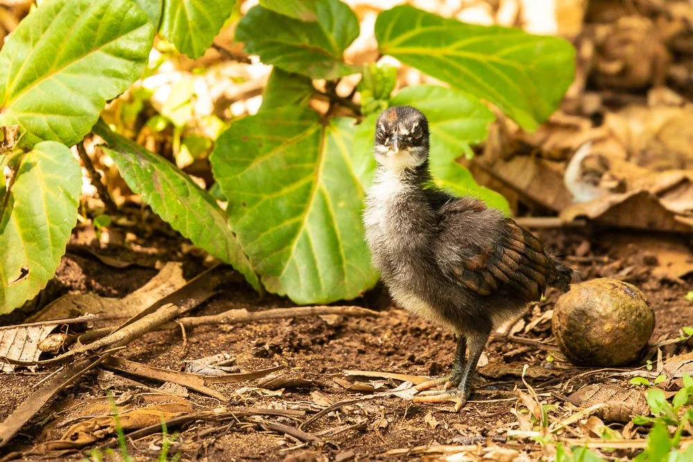
A baby chicken at the zip lining venue
Marie wanted to pet the ducks. She had a pet duck when she was little and taught us one time how to pet a duck. But these ducks weren’t very interested and refused to be petted.

One of the ducks
… and some of the others
It was time to put on the zip lining gear and get instructed. Only Marie and Kate were going to zip line while I was going to take photos and videos of them from the ground.

Getting instructed on zip lining
Getting started from the tower
When they were up on the wooden structures Marie was sending me pics she took of me and vice versa. Later Kate said that she was terrified at the first run, a little less scared at the second and totally used to it after the third run. One of my photos showed that very well, with her zipping down with a stern look.

Kate very relaxed zip lining

Zip lining over the pond
I also took my first photo of a growing pineapple, I had no idea that the plants carry only one pineapple at a time.

Pineapples on Maui
5. Researching Maui Nui | Hawaii 2021
5. Researching Maui Nui | Hawaii 2021
Day 5
We went to see the concierge to book the Molokini Crater snorkeling tour and zip lining. We were lucky as there was only one slot left for the snorkeling tour for the three of us. Wednesday morning at 7:00 at the harbor, so we’d have to get up very early. However, jet lag is your circadian rhythm following you slowly across time zones like a ghost and I felt my circadian ghost was still traveling somewhere between the San Diego and Hawaii time zones so that shouldn’t be too hard.
Marie also wanted to zip line with Kate and we booked that for the next day. My plan was to take pictures somewhere while they were doing that: perhaps on the plantation where the zip lining would take place or somewhere else nearby, I hadn’t decided yet.
We headed back to our room to start a lazy day not doing very much, again. We all took out our books we were reading. For me it was still Full Throttle by Joe Hill. I started on the story Faun, which includes - as the title implies without giving away spoilers - a faun. Okay, maybe more than one. I loved it.
Now it was time to do some research.
I looked up where we may be heading with our Teralini snorkeling tour on Thursday. It didn’t really say on their website, just “an excellent snorkeling spot”. I looked at some photos posted on their website and one of their drone photos of the spot looked familiar; I thought I recognized the shape of the bay somewhat. Taking into account the distance from where the boat leaves, I compared their drone photo with the satellite view of Honolua Bay on Google Maps and I was 99.9% sure they were the same.
While I was on Google Maps I zoomed out quite a bit and noticed that Maui, Kaho’olawe, Lanai and Moloka’i are pretty close to each other compared to the other islands. Perhaps they were one big island once? I went to Google and typed in “Were Maui, Lanai and Molokai one island”. Guess what? Yes they were. It was called Maui Nui, meaning Big Maui.
The Hawaiian islands that once were one
My initial thought about Maui Nui turning into several islands was that as Maui Nui was created by the hot spot while the pacific plate moves north west, the island sinks over time and the highest peaks of Maui Nui remained above the ocean - therefore becoming Maui, Kaho’olawe, Lanai and Moloka’i. There are lots of underwater mountains and atolls stretching 1500 miles northwest (much further than Kauai) of which some that are now underwater at some point have been above ocean level. However, there is another effect. One of the websites mentioned that ocean levels have varied with ice ages with much lower sea levels during those ages. Even “only” 20,000 years ago Maui, Kaho’olawe, Lanai and Moloka’i were joined together. Cool stuff.
…. and the sunset for that day
4. Base Camp at Kāʻanapali Beach | Hawaii 2021
4. Base Camp at Kāʻanapali Beach | Hawaii 2021
Day 4
We considered two options in the morning. 1) driving to the Honolua Bay, which is only a 15 minute drive, or 2) just sit on the beach all day, right in front of our hotel, so we didn’t have to drive anywhere. Both Kate and Marie were on board with that last lazy option.
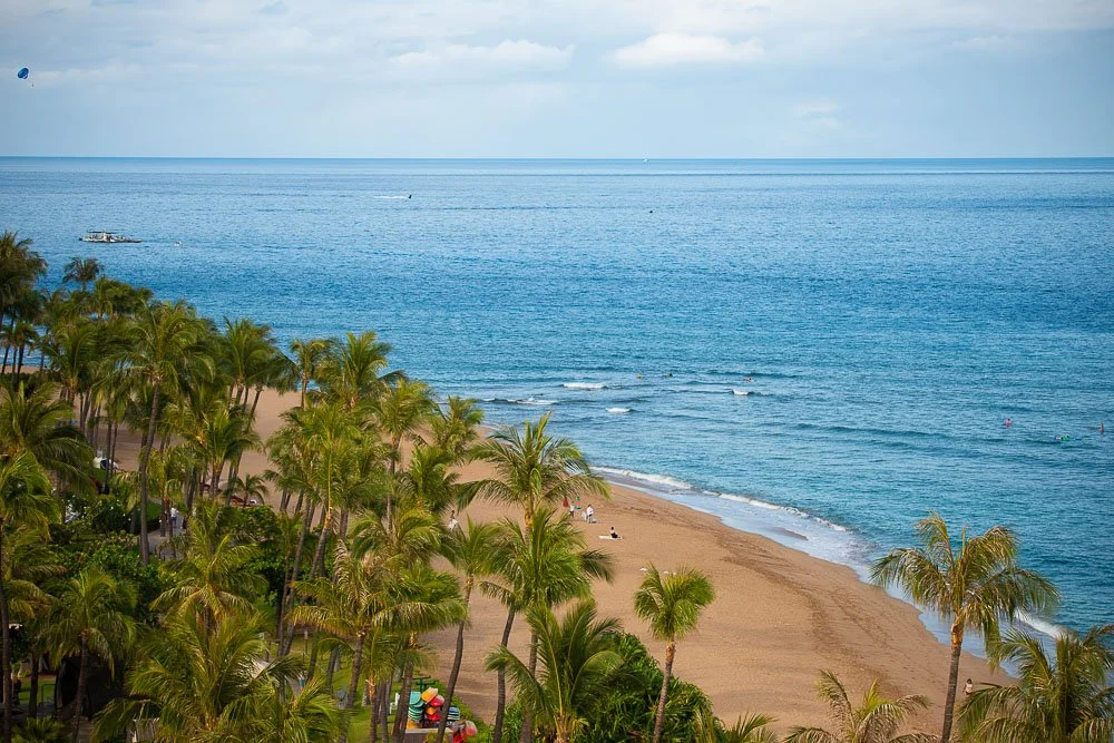
Kāʻanapali Beach view from our room
From a hotel employee we learned that Bruce Willis was at the hotel, shooting a movie “Paradise City” with John Travolta. We were joking that it was the perfect time because nobody would recognize them wearing their COVID masks.
While we were waiting in line to rent two umbrellas and three beach lounge chairs, a lady waiting in line behind us said that the hotel is at 100% capacity. If that’s the case we probably should book a snorkeling boat trip as soon as possible. We went online and yup, everything was booked till Thursday so we made a reservation with Teralani Sailing Adventures for that day.
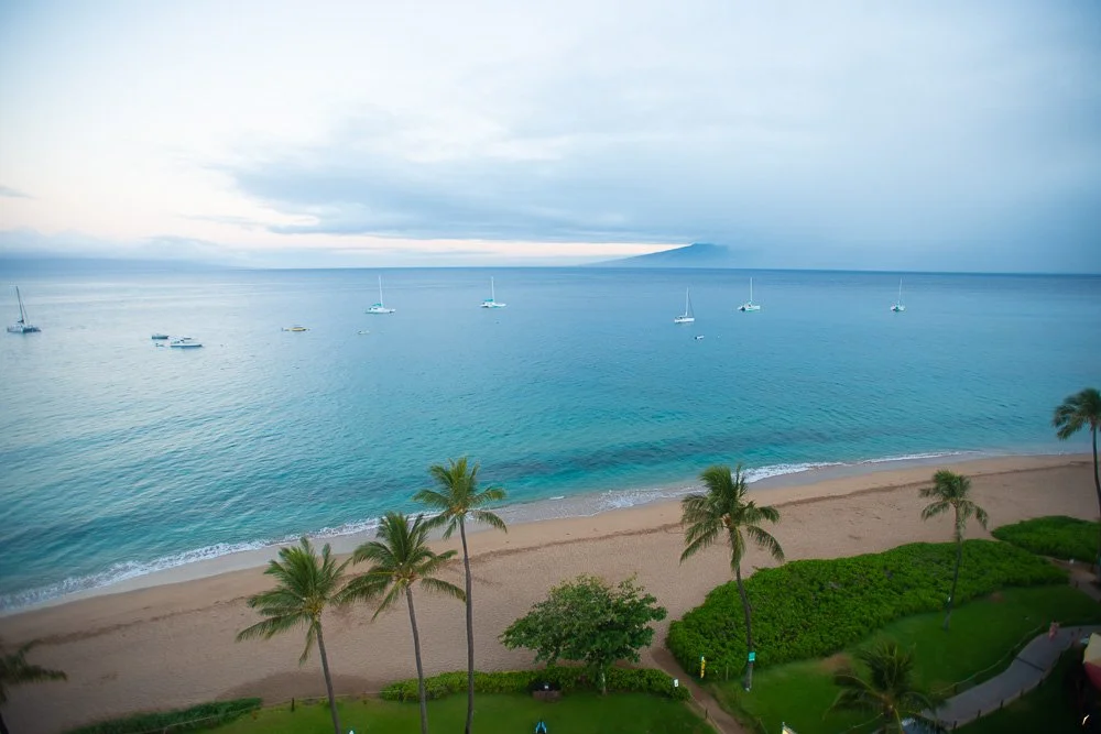
… and the view in the other direction
After our base camp was setup on the beach, I told Kate I would just run and jump into the ocean at high speed. Normally I’m a wuss when it comes to going into the ocean (especially in San Diego), but hey, the water is not that cold here. I stood up, straightened my back, put my chin up and said “Today I’m not a wuss”. Both Marie and Kate were joining me. We ran and dove. Kate was laughing hard about the whole ordeal. As normal, Marie and Kate tried to drown me.
After surviving my family we headed back to our base camp. That’s where we all did a lot of reading over a couple of hours. It was nice to be out of the sun under the umbrellas.
At some point Kate and Marie went back in the water and Kate called me. She said that if I ran into the ocean again they wouldn’t try to drown me. So I did and they kept their end of the deal. A guy in the water said he thought someone was in trouble and that I was going to go for a rescue, Baywatch style.
I noticed bright lights in three rooms at the top floor of one of the hotel buildings. Probably the movie set! Now I want to see it in the theater as a shot from those rooms could show me running like David Hasselhoff into the ocean.
One of the best sunsets yet
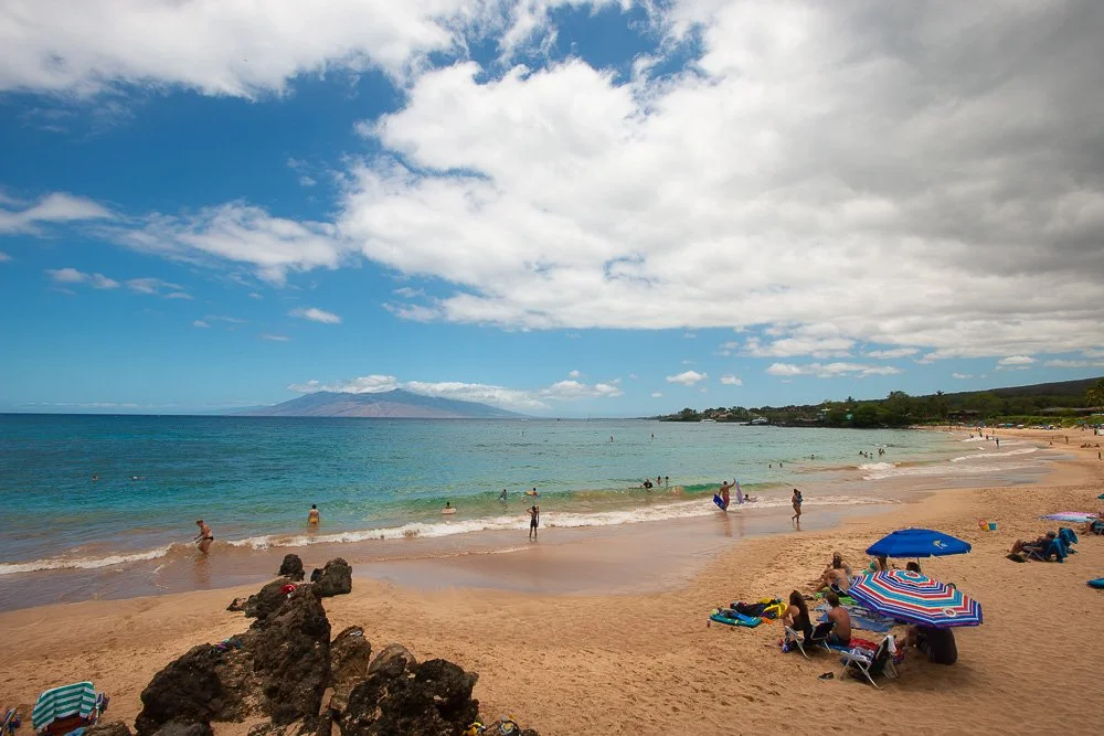
3. Maluaka Beach | Hawaii 2021
3. Maluaka Beach | Hawaii 2021
Day 3
After packing our snorkel gear and putting on our bathing suits we left for Maluaka Beach. It was a 45 minute drive from our hotel. The parking lot was quite full already but still some spots left. We found the beach and put our stuff down on a patch of grass right next to it, under the shade of a tree. Kate wanted to go in the water without snorkel gear and just play around a little first. The water still felt a bit cold but we got used to it fast. We went back to get our snorkel gear and I also took my GoPro in its water proof casing.
Maluaka Beach
We all started snorkeling but both Marie and Kate had troubles with their snorkels: they are the kind with a valve on top, so when you submerge completely it should prevent water coming in. However, they didn’t work that well and they couldn’t blow the water out either. I don’t like those: just give me (and I guess for them too) a classic snorkel with an open top, with which you can easily blow the water out. Forget the always malfunctioning valve ones. So Kate and Marie headed back and I continued. I swam a little further off shore where I found more coral on big rocks and red pencil sea urchins. I saw more new fishes than I witnessed yesterday, including a group of light blue fishes sitting together on the sandy bottom. That looked funny as if they were having a meeting or something. I recorded a couple of videos where I dove under and swam between the coral covered rocks.
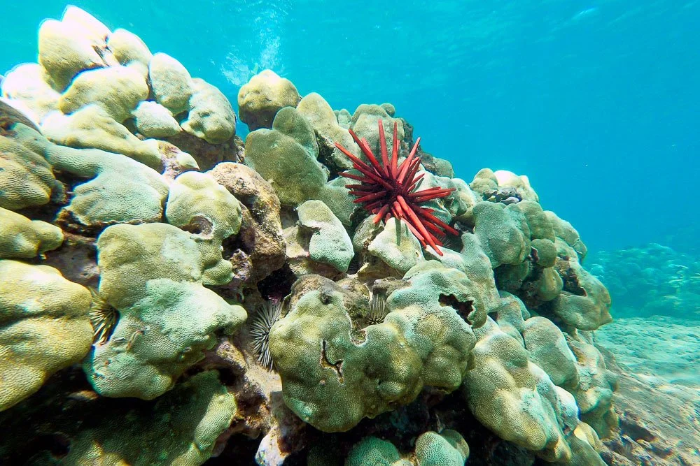
A red pencil urchin on coral
When I crawled back on the beach and met with Marie and Kate we decided to grab some lunch, with chickens all around us. I checked if perhaps we could go on a hike nearby but Kate was too tired and falling asleep on the backseat.
Lots of chickens at the mall
Back at the hotel we played shuffle board at the Lanai restaurant with some variations that Kate came up with - including sliding all the sliders at once for both players. We walked over to Whaler’s Village and bought a classic snorkel. Hopefully this one is going to work for Kate!

Kate scoring at shuffle board
Back in the room I researched some hikes and found the Pipiwai Trail in Haleakalá National Park, with water falls, a bamboo forest and awesome views. It’s a more than two and half an hour drive but probably worth it! The funny thing is that according to Google Maps the last 30 miles is about 1.5 hours of driving; I wonder why? Well, we would find out on day 9…
2. Kāʻanapali Beach | Hawaii 2021
2. Kāʻanapali Beach | Hawaii 2021
Day 2
I slept well, even though I woke up a couple of times, hearing the soothing waves. I finally got up at 6am (9am San Diego time), which is one of the longest nights I’ve slept.
We had breakfast at the Lanai restaurant sitting on chairs in the inside pool with our feet in the water.

Eating breakfast at the Westin Resort
I did some research on good snorkel spots and wrote down a few: Moluaka Beach at Turtle Town, Molokini Crater, Black Rock and Honolua Bay. Today we didn’t want to drive anywhere so Black Rock was the obvious choice as it is only a 15 minute stroll along the beach. Before we left, I told Kate about Molokini Crater: that it’s a half submerged crescent shaped crater with lots of sea life and 100 feet visibility, with reported 200 ft sometimes…!
“There are lots of fish, octopuses, and sometimes a particular type of fish. Its name sounds more scary than it really is.” I told her.
“Hmmm, that doesn’t sound so good.”
“They can be about the length of our balcony” (30 feet). “They are very cute and you can pet them.”
She laughed and said “Okay, so you’re saying they are giant and adorable.”
“Exactly! They are called whale sharks. But don’t worry, they are slow and only eat plankton.”
“Yeah, I’m still not sure I want to meet one”, looking at me with suspicious eyes.
Time to head for Black Rock Beach. Apparently people like to jump off this rock. Depending on the tide the height varies between 12 and 18 feet. But we were here to test our new snorkel gear and see some fishes. There were no fish in the sandy part but when we got closer to the rock the bottom also became more rocky and saw some yellow tangs, black durgons, and humuhumu-nukunuku-apua’a’s. But not many.
Hawaii’s state fish, the humuhumu-nukunuku-apua’a
We took a break on the beach. Kate liked to be carried around on my back in the water and I was exhausted. Marie asked if it was my toughest workout since we trained for the Carlsbad half marathon. It sure felt so.
My wife and daughter in the waters near Black Rock
Kate snorkeling
Noon was approaching and we headed back to the beach in front of our hotel. Turned out, there was a reef right there too with even more fishes. Marie was tired and wanted to take a nap. She headed back to the room while Kate and I swam around a bit longer. Kate and I ordered food at the bar and also headed back up. We ate our lunch on the balcony while enjoying the view.
As we were sticking to our plan to not go very far today, we headed back to the pool. Marie and Kate went swimming whereas I laid down on a beach chair and kept reading Joe Hill’s “Full Throttle”. I started that book in the plane. I enjoyed very much reading his honest description of his journey to becoming a writer. I continued with the next chapter. It was very hot though sitting in the direct sun even though I was wearing my awesome Anza-Borrego safari hat (both my wife and mom disagree with me on that point) and had put a towel over my legs.
My awesome Anza-Borrego Desert State Park hat
When Marie and Kate came back we decided to relax at the Lanai, have some cocktails (Kate a “POG”, a pineapple-orange-guava juice drink) and play some shuffleboard. When we sat down, Marie and Kate read and I wrote down my description of our first day on my iPad. We also had a simple dinner (we were still quite full from our lunches) and headed back to our room. I sat down on the balcony and started writing about this day.

Writing about the day on my iPad
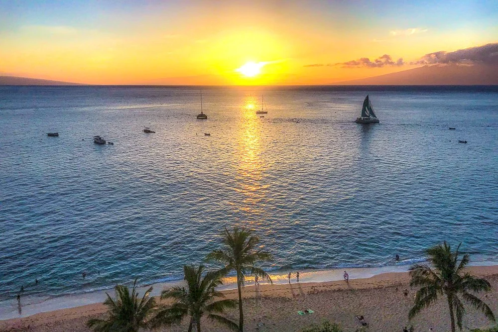
1. From San Diego to Maui | Hawaii 2021
1. From San Diego to Maui | Hawaii 2021
Pre-trip
Because the COVID pandemic is not quite over yet in May 2021, visitors to Hawaii need to quarantine for 10 days. However, if you test negative for the disease within 72 hours of your trip, you are exempt from quarantining. Our trip is going to last for 10 days so of course we don’t want to stay in our room for that period of time and then leave again without having been outside. So all three of us - Marie, Kate and I - got tested. And, woohoo, all three negative! If only one of us either tested positive or test results were inconclusive we wouldn’t go (imagine one of us being quarantined: “Hi honey, we saw dolphins and turtles today, but we brought you some dinner!”). We uploaded our tests to the Hawaii travel website and were exempted from quarantine. We received QR codes on our phones we could use at the airports. Maui, here we come.
Day 1
We got up at 6am, did our morning thing, and at around 7:30am we were dropped off at San Diego Airport by our friend Jill who was also house sitting for us. We had already checked in the day before and we only needed to check in our two bags. At the self check-in an Alaskan Airlines representative asked if we had our wristbands. My first thought was “Oh no, I forgot to do something and now it’s all messed up”. Turns out you can get those when you show your QR code. After dropping off our luggage we received our wristbands. A relief.
Our plane left - that is, with us in it - on time at 9:55am. I forgot how long it takes to get to Hawaii as the pilot announced it to be 5 hours and 40 minutes over the PA. After seeing clouds forever with some blue in between them we started to descend and spotted land. Kate was at the window and I was sitting next to her. I was guessing maybe that it was the Big Island (which we visited last time), but the plane started to turn and go for the landing. It was Maui. The pilot had mentioned that there was a strong east wind which worried Kate and me a bit - we both get motion sickness easily - but the landing was actually relatively smooth. We were good. The flight attendant announced that we may have to get tested at the airport, unless we had our vaccination cards with us. Marie and I did, but Kate had just turned 12, so she wasn’t vaccinated yet, but I did bring a printout of her negative test.
We had to wait on the tarmac for quite a while but finally we were de-boarding the plane. It was 80 degrees Fahrenheit (27 degrees Celsius), which felt nice after the much cooler cabin temperature. The luggage carousels were fenced off and everybody was directed towards an area where you had to show your vaccination cards. Marie and I received our get-outta-jail-free-cards but when they asked how old Kate is and she said 12 we were redirected to the testing area. I showed her negative test printout but that didn’t help. Marie had to swab her nose and at least that part was fortunate so it wasn’t that painful for Kate (as opposed to the tests we got three days before). Kate also received her get-outta-here ticket and we headed to the car rentals.
That went pretty smoothly and when we hit the road, Marie announced that the vacation had officially started. I google mapped our directions and it said it was 40 minutes to Kāʻanapali Beach. During our drive we saw several other islands in the distance (the tiny Molokini Crater, Kaho’olawe, Lānaʻi and Molokaʻi).

Lanai viewed from Maui
At our resort we parked our car and checked in. We had to show our QR codes again, received our wristband keycards (ingenious), and headed to our suite on the 9th floor. We were supposed to have a full ocean view, and walking down the hallway westward was a good indicator we were going to have one. And behold:
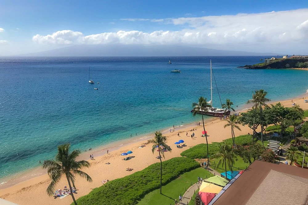
The view from our room
We sure did. The entrance door led to the living room in the middle; to the right was the bathroom with a beautiful free standing tub and separate shower. And of course also a giant glass sliding door looking out over the ocean and the island. To the left was the bedroom, with floor-to-ceiling glass sliding doors facing west and north. Not too shabby.
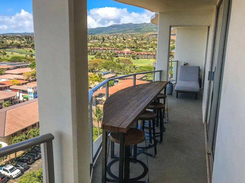
The view to the other side from our balcony
We put on our bathing suits and headed to the pool area. There are three pools outside and one pool that’s inside a cute little restaurant, where you can sit in the water and look out over the ocean. We jumped around a bit in the outside pools after which we went to the ocean. The water was just as warm as the pools and I prefer the ocean anyway. The waves were not very large. The white sand on the beach felt nice and soft. On the horizon the islands of Lānaʻi and Molokaʻi were clearly visible, with a hazy and far-away O’ahu in between them. Marie and Kate tried to drown me and I let them after a bit of resistance.
We went back to our room and enjoyed the beautiful sunset from there at 7pm. The sky turned from blue to warm colors pretty quickly, with sun rays bouncing off the underside of the clouds. We all went to bed at around 8:00 (11:00 San Diego time) after this long day.
And the view right before we went to bed